You are using an out of date browser. It may not display this or other websites correctly.
You should upgrade or use an alternative browser.
You should upgrade or use an alternative browser.
Steglitz
- Thread starter Oz_Gold
- Start date


Help Support Prospecting Australia:
This site may earn a commission from merchant affiliate
links, including eBay, Amazon, and others.
Sorry mate cant help ya, i might of done a post a while ago that involved Steglitz, cant be to sure, im thinking it was under "nightly post" in the general chat section. ")
Hi Oz_Gold,
If you're talking about Steiglitz in the Brisbane Ranges between Geelong & Ballan,
you can only pan one kilometre downstream from the Meredith Rd bridge in Sutherlands Creek, you can use pans, cradles & hand tools
within the creek bed only.
You can use detectors everywhere else in the park, however being a Historic Area you are prohibited from digging anything up!
hope this helps, if your in that Area you could up around Blackwood & Trentham(hard work though)
Cheers-Markez
Thats the same reply i got you can use a detector but nothing can be removed so a bit pointless
Goldtarget
(AKA OldGT)
Catch and release nuggets...... Now I've heard it all.
G
Guest
What gets me with these areas is what point is there in leaving the relics in the ground to slowly decay to nothing. Not much use historically if no one can see them?
you'll just have to get out there and find out mate, no point asking everyone what every spots like each experience is their own. You know what i mean? one bloke will say its hard ground to walk with lots of cliffs etc and another bloke will say great cliff banks to detect lots of benches easy ground. ...
G0lddigg@ said:you'll just have to get out there and find out mate, no point asking everyone what every spots like each experience is their own. You know what i mean? one bloke will say its hard ground to walk with lots of cliffs etc and another bloke will say great cliff banks to detect lots of benches easy ground. ...
Absolutely - I agree - I personally wouldn't have a problem walking rough/tough ground - I guess my interest is more whether or not there's still stuff to be found. Being a newbie, and the fact I'd have to hire a detector, I want to target somewhere with a good potential of finding stuff. No point my targeting Dolly Creek if everything is in the creek bed (panning, sluicing) and I want to detect for nuggets and target the side of the hill. Some of my questions will seem stupid as I'm still learning about the way it all works - my apologies.
I've been trying to find old maps etc that define the reefs etc in the different mining areas - do they exist? i.e. at Dollys I notice that gold has been found in all of the creeks upstream of the bridge including the tributaries - that all has to come from somewhere. A map with the known reefs would be helpful as I figure you'd have good potential on the downside of those reefs between the reef and the water.
Thanks for your patience and apologies for the newbie questions... I'm certainly not expecting gps coordinates to a nugget and appreciate that the only way you'll ever find gold is to put in the effort - nothing comes easy and where would the thrill of the chase be if gold came easy lol
no apologies needed mate i'm just saying no ones going to tell you where the nuggets are, and if someones telling you well they've already been over it trust me. I's start with a few of doug stones maps and then use geovic to cross reference and get your walking boots on. your going to find fun stuff anyway in between gold and that makes it all the more fun.
Look at all this crap ive got from the GMT on a few outings. the further out you go the less junk (sometimes)

Look at all this crap ive got from the GMT on a few outings. the further out you go the less junk (sometimes)
Hi Oz_Gold,
What I mean by "hard work" is Blackwood can be unforgiving, it is very steep & with lots of under growth, I take a steel rake with me just so I can swing close to the ground, I hope to get back in there in the coming weeks as they (DEPI) have conducted prescribed burns in certain areas & with a mining lease being granted recently there has to be more gold left to be dug up, it's just a matter of getting out & swinging,
cheers-mark
If only I had my own detector lol. I camped along the Lerdederg Rd down by the river a few times and found a few awesome shafts! One is in the side of a hill and you can walk in a fair way - water was flowing out of it last time I was there - the other is a massive fenced shaft - not sure how deep it is. I've camped along the river but never thought to pan there! Let alone swing there
- Joined
- Feb 26, 2013
- Messages
- 3,271
- Reaction score
- 4,826
Some info on Doll Creek here = https://www.prospectingaustralia.com/forum/viewtopic.php?id=6021
- Joined
- Dec 28, 2015
- Messages
- 30
- Reaction score
- 10
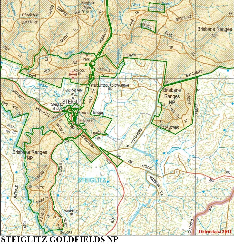
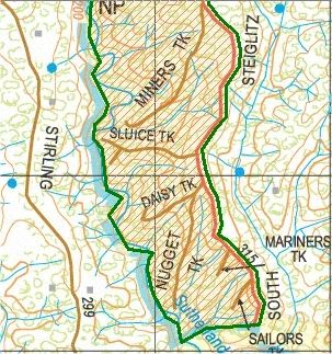
Just an update on Steiglitz Historic Gold town. I was there a couple of days ago and spoke to a long time resident.
Panning is allowed one kilometer down from the Meredith rd bridge in the Southerland creek. Its a dry creek bed which might have water in various parts after heavy rain.
You cant drive to the area even though there is a track which is reserved for park rangers and land management. It has a locked gate.
On google maps there are numerous roads showing around the town however they are historic roads that no longer exist. There is only the main road through the town.
The area looks quite big including the surrounding ranges in fact it is so small that you could drive around the entire area in around half an hour.
Most of the hills and ranges are occupied by private properties which sit side by side so there is nowhere you can go outside of the town to duck into the bush and fossick with a metal detector.
the local resident said the creek used to be good for panning but is next to not worth it anymore.
Its a good thing that the creek near the bridge has been preserved because looking from the bridge itself its a picturesque piece of beauty and a great place for any gold panner to study the pebbles, rocks and boulders and general creek bed layout.
If you did walk around there with a metal detector you will probably get chased out of the place even if you weren't digging up the ground.
With many of the gold mines butting right up to the back door of many of the old houses that were there it probably isn't worth the effort to even fossick around the place with a detector anyway.
Its worth a visit though to get a feel for what it was like back in the gold rush days. Take the family and pack everything you need for the day as you wont find a supermarket or service station there.
The old cemetery just out of town is worth a look too. It looks like something form an old black and white 1930s movie. remember that there are grave stones lying on the ground and being so old you will be walking over old graves so please respect the area if you go in there.
There are plenty of hiking tracks in the area and watch out for old mine shafts. You'll also come across a few mullock heaps too.
There are only a handful of buildings there so don't be disappointed when you arrive. I highly recommend reading the history boards which will take you right back to the gold rush days.
EP
Oz_Gold said:G0lddigg@ said:you'll just have to get out there and find out mate, no point asking everyone what every spots like each experience is their own. You know what i mean? one bloke will say its hard ground to walk with lots of cliffs etc and another bloke will say great cliff banks to detect lots of benches easy ground. ...
Absolutely - I agree - I personally wouldn't have a problem walking rough/tough ground - I guess my interest is more whether or not there's still stuff to be found. Being a newbie, and the fact I'd have to hire a detector, I want to target somewhere with a good potential of finding stuff. No point my targeting Dolly Creek if everything is in the creek bed (panning, sluicing) and I want to detect for nuggets and target the side of the hill. Some of my questions will seem stupid as I'm still learning about the way it all works - my apologies.
I've been trying to find old maps etc that define the reefs etc in the different mining areas - do they exist? i.e. at Dollys I notice that gold has been found in all of the creeks upstream of the bridge including the tributaries - that all has to come from somewhere. A map with the known reefs would be helpful as I figure you'd have good potential on the downside of those reefs between the reef and the water.
Thanks for your patience and apologies for the newbie questions... I'm certainly not expecting gps coordinates to a nugget and appreciate that the only way you'll ever find gold is to put in the effort - nothing comes easy and where would the thrill of the chase be if gold came easy lol
i.e. at Dollys I notice that gold has been found in all of the creeks upstream of the bridge including the tributaries - that all has to come from somewhere
Old info now I know, but the gold at Dollys Creek is actually in old river gravels of Tertiary age on the hilltop (but erosion has dispersed it into modern streams). The stuff in the old river gravels on the hill was brought there from a river that drained the Mt Egerton-Lal Lal goldfield area to the north and northwest. Quite a few nuggets have been detected on the hill at Dollys Creek. There are NO quartz reefs with gold there or at Morrisons to the south.
You can park about 100m from the legal panning spot at Stieglitz.
I wouldn't bother with a detector there, I've heard of on the spot fines, they take it pretty serious.
Just go a bit further north to Mt Doran. Lots of good looking ground in there.
I wouldn't bother with a detector there, I've heard of on the spot fines, they take it pretty serious.
Just go a bit further north to Mt Doran. Lots of good looking ground in there.
MarcusAureas
Mark Forster
Jarrod84 said:You can park about 100m from the legal panning spot at Stieglitz.
I wouldn't bother with a detector there, I've heard of on the spot fines, they take it pretty serious.
Just go a bit further north to Mt Doran. Lots of good looking ground in there.
Where does it say no detecting in the Historic Park Area = Also where is that car park
thats 100mt from river? Any map co-ordinates? as i couldnt find it last week.