Road Cutting / Face Strata Gallery & Discussion

Prospecting Australia

Help Support Prospecting Australia:

This site may earn a commission from merchant affiliate links, including eBay, Amazon, and others.
G0lddigg@ said:
have to google "Edwards' Pyrites & Ore Reduction Co" in affraid the links wont work here they are dynamic
heres a summary :

Background

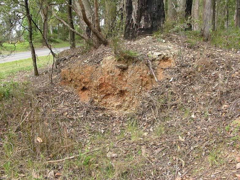
Edwards erected a building on the slopes of Frenchman's Hill, Sebastopol in 1890. Remains of the company can be seen behind the former garbage tip in Whitehorse Road, Sebastopol.
History

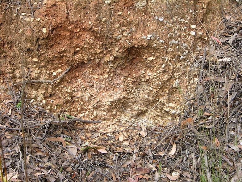
This company started operation around 1896. It roasted mullock and waste from local mines, as well as those further afield. The remains of the ore was called 'roasted ore' and was red in colour. Arsenic fumes from the plant killed much of the vegetation in the south east area of the plant. This problem was solved in later years be redesigning the chimneys at the plant. Many workers of the plant suffered chronic respiratory problems caused by the arsenic fumes. A large proportion of the slimes found their way into the creek by an overflow placed at the side of each vat.

Eight cyanide leaching vats held 100 tons each. The pulp was fed into them, by nicely constructed distributors.The golden solution was run through boxes containing charcoal, then the precious charcoal was dried and burnt. The ashes containing the gold were smelted in crucibles in the usual manner.
BALLARAT, September 16.
At the Police Court to-day the Buninyong Shire Council proceeded against Messrs. Edwards, of the pyrites works at Magpie, for treating pyrites without the consent of the Council, and thereby causing offensive fumes. Evidence for the prosecution was given by Henry Edward Geddes, a miner, who said the fumes from the works had affected the health of himself and children, and John Gullock, postmaster at Magpie, whose health had also been injured, and who had lost a horse through being poisoned by the gases from the works. Robert Knowles, a farmer, deposed that fumes had killed some of his cattle. Other evidence of a similar character was given. For the defence it was contended that no offence had been committed against the Act, which applied to abattoirs, factories, etc., and not to pyrites works. Dr. Atkinson, of Bendigo, said he was familiar with pyrites works in his districts, that the health of residents there was very good, and public health was not affected by the fumes in any way. Dr. McGillivray, Bendigo, corroborated, as did also Dr. Hugh Boyd, Bendigo. Mr. Cosmo Newbery said he was with the Noxious Fumes Board is their recent investigations, and they could not trace any ill effects to the community from the fumes of pyrites. The scorching of leaves of trees was due to sulphur. The effect on animal life was practically nil. As things were at present in the vicinity of the Magpie pyrites works he should say the cause of death of animals was not due to the fumes. On rising the Court adjourned until next day. [1]

The plant was closed during the 1930s. When the plant was no longer profitable the plant was used to manufacture sheep dip and paint. Remains of the company can be seen behind the garbage tip in Whitehorse Road, Sebastopol.

reference https://bih.federation.edu.au/

Far out! Imagine getting away with this today. :eek:
 
And a reverse or thrust fault at that!
jethro said:
Beat me to it AR I was going to start a thread for photos of Geological structures but this one will do.

Here's my first contribution.https://www.prospectingaustralia.com/forum/img/member-images/1297/1447455293_dsc000011.jpg

THe photo is not very clear as I took it using the stills function of my video camera. It is of a fault that has slipped vertically with a displacement of about 3 metres. with subsequent infilling with quartz and crushed slate. The bedding planes (darker layers of rock ) that were originally adjacent to each other are now at the bottom left of the photo & the upper right.
 
Beagleboy said:
G'day Atomrat,

I am just re reading this post as I find it quiet interesting. Above you mentioned Andersons Creek along Eastlink. Anderson's creek is in Warrandyte few k's to the north from Eastlink. I think you meant Mullum Mullum creek or have I got this wrong? I drive on Eastlink all the time and have not noticed this strata and dykes. Is it on Doncaster side of the tunnel or Ringwood side?

Here you go mate:

You can see the wall better on the north side from sattellite view here. This is the exact location of the dry creek anticline. Further east you will see the belview anticline, heading west on the freeway and you will see the "Columnar jointing in basalt". This should be very obvious and a black volcanic layer. It stretches for about 1km to view from the fwy :) You can even just see the fault lines ( dark ) from the sat view I just noticed on the north wall.
1450122516_14501224077591.jpg


This diagram ( facing south ) shows you the layers. Soft dyke far left, top leftish is a black arrow pointing down, that's the dry creek anticline. A soft sill far right
1450122546_14501223794280.jpg
 
The map is in Kew East. There is a similar wall in Mitcham. I will take a picture next time I am driving past.
 
Awesome mate that would be mad! Yes, its further west than I thought. I thought it was in ringwood haha
If you can get a shot of that wall which is paved now it would be great mate, but you may find it difficult. ( kew east sattellite photo cutting )
 
G0lddigg@ said:
Parks said:

This actually looks more like sedimentary bench material. Cant see how it would constitute a deep lead sorry.

It's the top of the Trentham Lead that flows north. I see it all the time on the way to a mates place near Creswick and thought I would just take a pic. It's the top of a deep lead that flows though Trentham. A deep lead is defined as over 100 ft, so this is not a deep lead, rather the top of a deep lead, the feed gully into a deep lead. I don't mind if members know where it is. It is at Trentham between the cemetery and tip. If you go there check out the left over soils from the grave digging that is out the back of the shed. It was known as the dry diggings.
 
AtomRat said:
Cheers Parks for submitting the first example! I've never seen a deep lead personally so I really like this as a first one! Is this near me at all? I don't get out to Tanjil often and I havnt heard of the deep lead there so super interesting again.

I can see some differences between this and standard alluvial I'm used to seeing. I think I've found some of this in warburton, woukd I be correct on this would u know Parks?

I thought the first example I'd be able to upload is of Andersons Creek / Dry Creek formation along Eastlink Freeway that many would know. Its nit been covered with paved rockes but they paved it in a way you can still see the strata and dykes

There is a big difference in rock types. I do not have photos available but if you can close your eyes and imagine for example; a slightly rounded edged piece of quartz from a creek, it has definitive sides and slightly rounded edges, showing it is rather young and travelled a short distance. The quartz from a deep lead or deep lead head creek will have a look like golf balls, very rounded and smooth. Sometimes you may find one of these rounded rocks in your prospecting and that means a deep lead is in the area. ;)
 
Parks said:
G0lddigg@ said:
Parks said:

This actually looks more like sedimentary bench material. Cant see how it would constitute a deep lead sorry.

It's the top of the Trentham Lead that flows north. I see it all the time on the way to a mates place near Creswick and thought I would just take a pic. It's the top of a deep lead that flows though Trentham. A deep lead is defined as over 100 ft, so this is not a deep lead, rather the top of a deep lead, the feed gully into a deep lead. I don't mind if members know where it is. It is at Trentham between the cemetery and tip. If you go there check out the left over soils from the grave digging that is out the back of the shed. It was known as the dry diggings.

my point exactly a deep lead as defined has been buried by meters of gravel,soils and detritus or even basalt but the lead is the material at the bottom which was worked. often only 1 or more feet deep and wide as 50 feet but they didn't leave any of the lead behind.
 
G0lddigg@ said:
Parks said:
G0lddigg@ said:
Parks said:

This actually looks more like sedimentary bench material. Cant see how it would constitute a deep lead sorry.

It's the top of the Trentham Lead that flows north. I see it all the time on the way to a mates place near Creswick and thought I would just take a pic. It's the top of a deep lead that flows though Trentham. A deep lead is defined as over 100 ft, so this is not a deep lead, rather the top of a deep lead, the feed gully into a deep lead. I don't mind if members know where it is. It is at Trentham between the cemetery and tip. If you go there check out the left over soils from the grave digging that is out the back of the shed. It was known as the dry diggings.

my point exactly a deep lead as defined has been buried by meters of gravel,soils and detritus or even basalt but the lead is the material at the bottom which was worked. often only 1 or more feet deep and wide as 50 feet but they didn't leave any of the lead behind.

There's heaps of leads left behind?? Most were left because the water was too much to pump and when they did mine they were very rough and didn't really take it all. They used to use a system where by you stick your shovel in the ground and take a scoop, shake it up and down, and if it made a clunk or felt heavy then keep it, otherwise chuck it beside in the waste. Bench material is down in the lead at the 100 ft or, what ever level. The picture is the top of a deep lead at ground level, still part of the deep lead system. It's like calling the Yarra the upper yarra and the lower yarra, it's still the yarra.
 
G0lddigg@ said:
Parks said:
G0lddigg@ said:
Parks said:

This actually looks more like sedimentary bench material. Cant see how it would constitute a deep lead sorry.

It's the top of the Trentham Lead that flows north. I see it all the time on the way to a mates place near Creswick and thought I would just take a pic. It's the top of a deep lead that flows though Trentham. A deep lead is defined as over 100 ft, so this is not a deep lead, rather the top of a deep lead, the feed gully into a deep lead. I don't mind if members know where it is. It is at Trentham between the cemetery and tip. If you go there check out the left over soils from the grave digging that is out the back of the shed. It was known as the dry diggings.

my point exactly a deep lead as defined has been buried by meters of gravel,soils and detritus or even basalt but the lead is the material at the bottom which was worked. often only 1 or more feet deep and wide as 50 feet but they didn't leave any of the lead behind.

You might be thinking of the ore body of the deep lead. The ore body contains the gold at a level in a deep lead. If you have to go over 100ft down to reach the ore then it's a deep lead. I think the cut off is at 40 ft. Above 40 ft is considered shallow workings. Below 40ft became a mine. Like out near Smeaton you get a series of mines along a deep lead. Deep leads don't have to be underground. When they are pushed up by volcanics they are still deap leads, and then called placer deposits.
So on the side of a mountain you may find the remains of an ancient river bed that is a placer deposit. If the river contains gold below 100 ft then it's a deep lead. If not it's a placer deposit
 
Parks said:
G0lddigg@ said:
Parks said:
G0lddigg@ said:
Parks said:

This actually looks more like sedimentary bench material. Cant see how it would constitute a deep lead sorry.

It's the top of the Trentham Lead that flows north. I see it all the time on the way to a mates place near Creswick and thought I would just take a pic. It's the top of a deep lead that flows though Trentham. A deep lead is defined as over 100 ft, so this is not a deep lead, rather the top of a deep lead, the feed gully into a deep lead. I don't mind if members know where it is. It is at Trentham between the cemetery and tip. If you go there check out the left over soils from the grave digging that is out the back of the shed. It was known as the dry diggings.

my point exactly a deep lead as defined has been buried by meters of gravel,soils and detritus or even basalt but the lead is the material at the bottom which was worked. often only 1 or more feet deep and wide as 50 feet but they didn't leave any of the lead behind.

There's heaps of leads left behind?? Most were left because the water was too much to pump and when they did mine they were very rough and didn't really take it all. They used to use a system where by you stick your shovel in the ground and take a scoop, shake it up and down, and if it made a clunk or felt heavy then keep it, otherwise chuck it beside in the waste. Bench material is down in the lead at the 100 ft or, what ever level. The picture is the top of a deep lead at ground level, still part of the deep lead system. It's like calling the Yarra the upper yarra and the lower yarra, it's still the yarra.

Of course theres leads left Lol shale the shovel common thats rubbish mate ive read half of every book and mining register and record for Ballarat and creswick the leads where worked out to their full extent. It want untill they got below the yarrowee and the pumps couldnt handle the load that they walked away. Either way they worked each deep lead out before continuing further into basalt and throught several feet of clay before hitting the next lead.

The "deep lead" is what is at the bottom not the sides the top or the edge its the load. Same as a shallow lead is the concentration of gold at the base of a gully or old shallow creek or runoff. Were splitting hairs here mate. I love a good debate

Read the fine print friend
1450418209_deeplead.jpg
1450418228_images2.jpeg
 
So what's the difference between a gold bearing creek and and a gold bearing deap lead?
 
Theres lots of differences Parks ill let you do your own research . Why are you replying to your owm statement. Why is tge sky blue?
 
II was going to edit the post but thought I would just quote and add in case anyone had read it and was replying in real time.

Read the fine print. So still really wondering?????
So what's the difference between a gold bearing creek and and a gold bearing deap lead? Both have gold bearing soils at the bottom and you say that a deep lead is defined as what is at the bottom.

I'm confused! Please explain.
 
Ooooo ..... Kay..... I'll just close the door on the way out. CLICK! And as I walk quietly away will make a note that it's in the fine print. Will make sure that I do not lick the fine print from Ballarat.
 
G0lddigg@ said:
Lol so dramatic Parks ... did you read the fine print about leads being worked out?

Ahh.. he heard a floorboard squeak while I was walking away. LOL

Yeh read it, but who's talking about mining Ballarat?
 

Latest posts

Top