Geological Maps - information and questions

Prospecting Australia

Help Support Prospecting Australia:

This site may earn a commission from merchant affiliate links, including eBay, Amazon, and others.
Gday shakergt

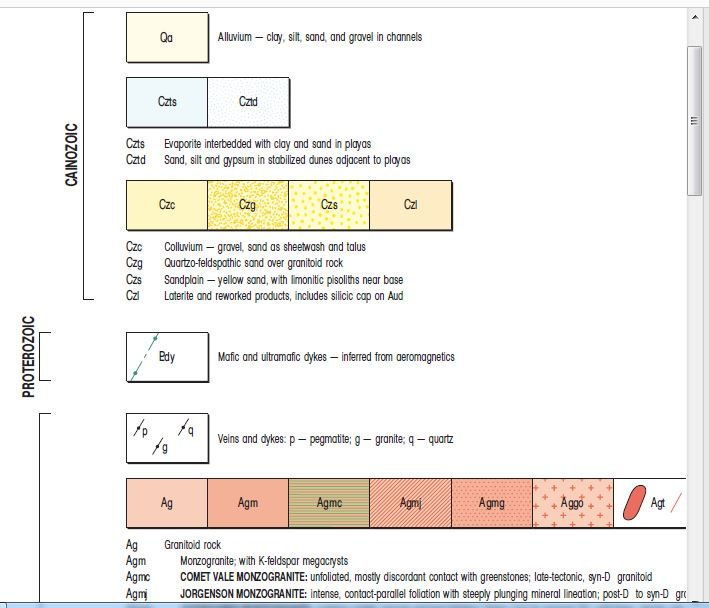
With the geology map abbreviations- the first letter of them is the time period-Ag would be A for Archeon period. The Czl would be Cz for Cenozoic period.
The next letter in the abbreviation would be for the rock/cover type. eg, Ag would be Archeon granite. The Czl would be Cenozoic laterite.
So its the same for Qa. Quaternary alluvium.
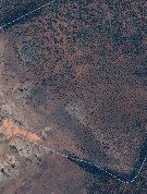
With the Czl over Ag in your part of the world id say it could be a good thing. You'd need to know what type of rock the Au deposits were formed in your area and where the source of the Czl was...
 
Shakergt, you have the relevant info for your area now. But realise that it varies from area to area (what you now know would apply throughout the Eastern Goldfields I guess, and that might keep you busy prospecting for the rest of your life unless you move). Yet you didn't say where you were. Keep in mind that if you do go elsewhere, gold will be in rocks of a different age and the gold may be of a different age. Also, where you look depends on the type of gold you are chasing, even where you are. Alluvial gold will be in stream gravels (which may be young in valleys or old on hillsides). Reef gold may be in the older Archaean rocks. Lateritic gold associated with ironstone and laterites. And eluvial gold washing down the hillside from most of these sources.
 
Re What to look for

Have seen Fault lines on maps B4, cannot recall if it was a Geology Map, should you detect in areas around a fault line ( side of hill/gully etc) in likely country first.

Peter
 
goldierocks said:
Shakergt, you have the relevant info for your area now. But realise that it varies from area to area (what you now know would apply throughout the Eastern Goldfields I guess, and that might keep you busy prospecting for the rest of your life unless you move). Yet you didn't say where you were. Keep in mind that if you do go elsewhere, gold will be in rocks of a different age and the gold may be of a different age. Also, where you look depends on the type of gold you are chasing, even where you are. Alluvial gold will be in stream gravels (which may be young in valleys or old on hillsides). Reef gold may be in the older Archaean rocks. Lateritic gold associated with ironstone and laterites. And eluvial gold washing down the hillside from most of these sources.

Don't want to be moving in a hurry. I am in Esperance so Norseman, Kalgoorlie and Coolgardie are not that far away but in saying that I do like head a fair bit further north of these places into real remote places. I could be wrong on this but I work on the theory of the further away from civilisation the better your chances of finding yellow. Of course this goes with research on an area before I go and so far every time I have been out I have found gold.
 
shakergt said:
goldierocks said:
Shakergt, you have the relevant info for your area now. But realise that it varies from area to area (what you now know would apply throughout the Eastern Goldfields I guess, and that might keep you busy prospecting for the rest of your life unless you move). Yet you didn't say where you were. Keep in mind that if you do go elsewhere, gold will be in rocks of a different age and the gold may be of a different age. Also, where you look depends on the type of gold you are chasing, even where you are. Alluvial gold will be in stream gravels (which may be young in valleys or old on hillsides). Reef gold may be in the older Archaean rocks. Lateritic gold associated with ironstone and laterites. And eluvial gold washing down the hillside from most of these sources.

Don't want to be moving in a hurry. I am in Esperance so Norseman, Kalgoorlie and Coolgardie are not that far away but in saying that I do like head a fair bit further north of these places into real remote places. I could be wrong on this but I work on the theory of the further away from civilisation the better your chances of finding yellow. Of course this goes with research on an area before I go and so far every time I have been out I have found gold.
Nice country. I used to intersect free gold in my nickel exploration drillholes around Bulga Downs and Birrigrin (Victoria Well). Wasn't worth anything in those days, so I wasn't allowed to spend money assaying it. Probably success might be more related to distance from the road than distance from Kal. :cool:
 
So true goldierocks. I do get a fair way from the roads also. I have not been out that way yet to Victoria well Mason way. Unfortunately some good looking land out there is under reserve management.
 
Ok folks, along the same line of the original question. I can't seem to navigate tengraph to get the geology legend. We are located in the Kalgoorlie gold fields.

1587805924_screenshot_20200425-171041_copy_303x370.jpg


What is the blue line marked Ac? Is this a fault of Ac rising through the Czl?

What is the line with the 80 pointing to it?

The yellow dotted area is Cza.

1587806075_screenshot_20200425-170251_copy_135x178.jpg


Satellite shot of the same area.

There is what looks like a faulted ridge along the blue line with the highest point being at the top of the Czl.

Thanks in advance.

Cheers

Doug
 
Rockhunter, the legend doesnt exist in Tengraph directly. Seems a bit stupid hey!
It does exist in another section, but off the top of my head I cant recall exactly where. I have copied a fair bit of it into a file somewhere.
I will dig thru my data & see if I can find it, & will post it up if I do

DED
 
I remember now why I havent gone after lots of these datasets
It is painfully tedious to get to.
I have the Kalgoorlie SH51 dataset in a compressed.zip file but it is 379MB. so i dont know if I can email it.
By following the instructions in the link above you can eventually get to any of them.

hope this helps some/all people
DED
 
Doug,

There is a book you can get that gives you all the info on how to read geo maps it may have been from the mines dept not sure
I will have to check unfortunately I cant go to the book shelf as I havent been home for a month due to the travel restrictions
I will have a look in the files on the computer the info may be there on the phone at the moment

Cheers Nanjim
Jim
 
Nanjim said:
Doug,

There is a book you can get that gives you all the info on how to read geo maps it may have been from the mines dept not sure
I will have to check unfortunately I cant go to the book shelf as I havent been home for a month due to the travel restrictions
I will have a look in the files on the computer the info may be there on the phone at the moment

Cheers Nanjim
Jim

Thanks Jim, any help is good help. Becoming a geo nerd will help me more in the field but so for I have learnt that "gold is where gold is".

Cheers

Doug
 
I would have loved to have offered you some sound and helpful advice Doug....but as you know it's you I normally turn to when I need help with tengraph and geo stuff...I suck at it! :D
 
There has been several negative comments regarding granite related too gold.
During my wandering on the WA goldfields, if a granite outcrop is sighted protruding above ground, I head straight for it. Have found countless nuggets in immediate area around the granite protrusions. If a granite ridge is encountered, a couple of laps back and forward at the base, adjacent to the granite occasionally reveals gold content.
As we all know, quartz, ironstone, greenstone & gold have a close association.
Greenstone; If you come upon an area where the greenstone is protruding from the ground like multiple bayonets, get excited because invariably there will be gold in and around this area.
 
Rockhunter62 said:
Ok folks, along the same line of the original question. I can't seem to navigate tengraph to get the geology legend. We are located in the Kalgoorlie gold fields.

https://www.prospectingaustralia.co...4_screenshot_20200425-171041_copy_303x370.jpg

What is the blue line marked Ac? Is this a fault of Ac rising through the Czl?

What is the line with the 80 pointing to it?

The yellow dotted area is Cza.

https://www.prospectingaustralia.co...5_screenshot_20200425-170251_copy_135x178.jpg

Satellite shot of the same area.

There is what looks like a faulted ridge along the blue line with the highest point being at the top of the Czl.

Thanks in advance.

Cheers

Doug

I think from memory Ac is chert
 

Latest posts

Top