Bathurst Members (or nearby areas + others interested in NSW areas)

Prospecting Australia

Help Support Prospecting Australia:

This site may earn a commission from merchant affiliate links, including eBay, Amazon, and others.
So good!

As a kid I used to go to Bathurst to visit my grandparents. Thanks to your hard work I have new reasons to visit.

Good decision! Look forward to seeing the giant gold panner dude on my way into Bathurst again soon!

Hey, does he have a name? I just remember being stoked seeing him, knowing I was finally there!
 
That is fantastic mbasko but could you please explain the legalities, guidelines and courtesies of entering or accessing Common Areas, Crown Land, Historic Sites and with permission onto Private Property for the purpose of fossiking in designated EL Tenements (see bellow) which fall within fossiking district #59.

Thank you,

Ross

1472952179_hill_end_gold_tenements.png
 
I tried to overlay images to scale for boundary outline over Geology/Tenement Map but I can not do it with Windows Paint but does seem Bathurst Fossiking District #59 Boundary includes Hill End and South of Hill End?

1472956575_fossiking_district_59.png
 
yass00_Au said:
That is fantastic mbasko but could you please explain the legalities, guidelines and courtesies of entering or accessing Common Areas, Crown Land, Historic Sites and with permission onto Private Property for the purpose of fossiking in designated EL Tenements (see bellow) which fall within fossiking district #59.

Thank you,

Ross

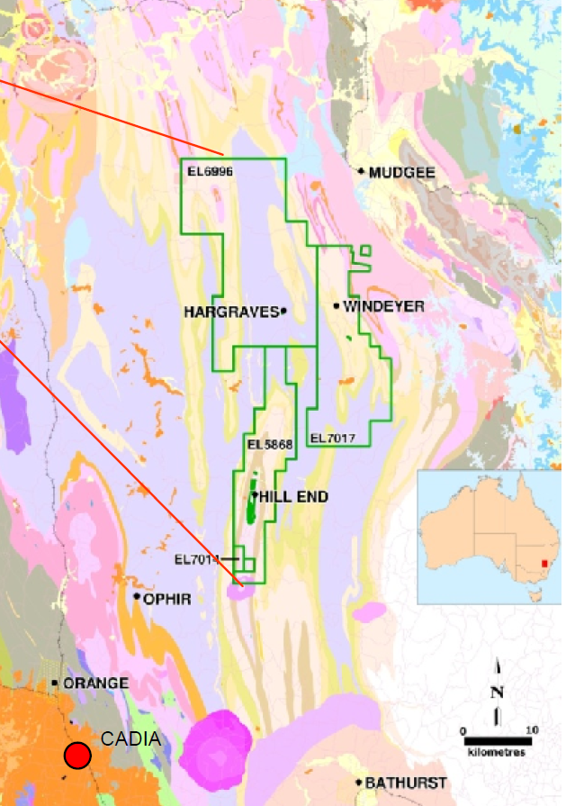
https://www.prospectingaustralia.co...es/320/1472952179_hill_end_gold_tenements.png
Not 100% sure what you want to know here? Anyone fossicking in NSW (or elsewhere) should know the legalities, guidelines etc.
Basically by becoming a fossicking district it removes the legal requirement of obtaining the EL holders permission to fossick/prospect on land under that EL where you otherwise have landholder/owner permission or a legal right to access the land.
This includes:
- Vacant crown land (unmanaged/untenured)
- Crown land under management with the land managers permission such as Commons, TSR' s, managed reserves etc. Some of these areas have known or standing permission to fossick in place - others don't. The onus to know is yours.
- Crown land under tenure & private property with landholders or land owners permission. Again the onus to know what land is under tenure or private property is on the fossicker/prospector.

It does not include:
- designated historic sites, National Parks & Wildlife Service controlled land such as NPWS historic sites, National Parks, State Conservation Areas, Wildlife Refuges/Reserves etc.
These areas are off limits as they have always been.
 
yass00_Au said:
I tried to overlay images to scale for boundary outline over Geology/Tenement Map but I can not do it with Windows Paint but does seem Bathurst Fossiking District #59 Boundary includes Hill End and South of Hill End?

https://www.prospectingaustralia.co...ages/320/1472956575_fossiking_district_59.png
Yes it includes Hill End to north of Tambaroora (I believe Ullamulla - Dixons Long Point Rd forms the northern boundary. From memory there is a sign or signs for Bathurst Regional Council & Mid Western Regional council areas?). It also includes south of Hill End through & south of Bathurst, east past Sofala/Wattle Flat etc.
Keep in mind you still can't go onto the various mining leases (ML, GL & DL) & private property in the area without permission. The fossicking district/s only remove the need to obtain EL holder permission - ALL other required permissions remain!
 

Latest posts

Top