- Joined
- Sep 23, 2015
- Messages
- 22
- Reaction score
- 31
Howdy,
Some great topics in this Maps and Resources forum. Some of the topics relate to this so I thought I would post a thread about what I know and have been using for a few months now (as a geologist and newbie prospector with a GPX 4500 and very little gold to show for it....yet).
There is a few ways that you can create georefenced maps - after many failed attempts at running down rabbit holes with different software packages I stumbled across a free way of doing this.
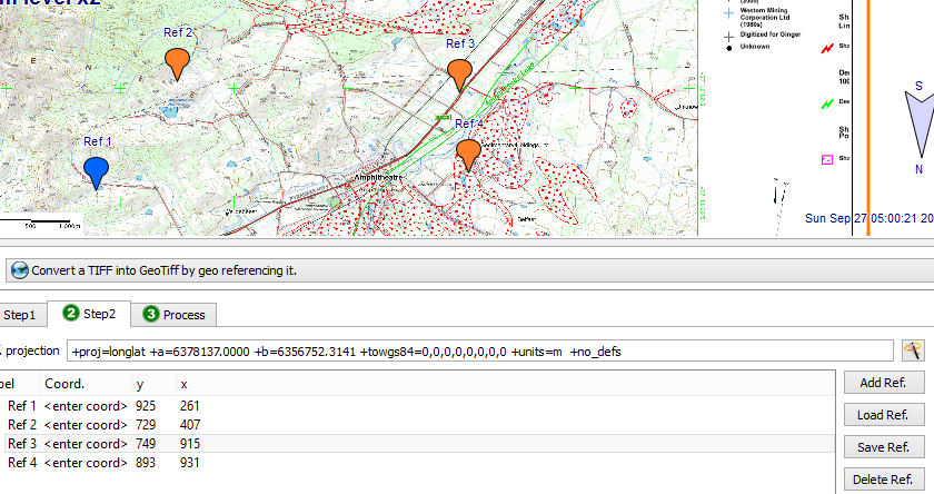
For those that don't know a georefrenced image (pdf or tiff etc) has a signature attached to it which places it in space, effectively a global reference point, so when utilised in certain apps or software on things like (location services enabled) iPhones or IPad you can see your actual live position on the screen. Similar to how Hema topo map products work on various platforms. The difference being that you can create these maps yourself after exporting (pdf print function) on Geovic (or other maps from other sources) to create an image, that can then be georefrenced and used on your iphone.
Have successfully been utilising this around central Victoria with geovic outputs of mineral occurrences, topographic 1:25000, shafts, workings, public land boundaries etc etc and typically it puts me dead on the spot along tracks, at shafts etc. Good for traversing, pin pointing, preparing target areas at home which can then be chased when you get to the field.
This is going to take a few messages to cover it, as too much info to put in one sorry. Really just gauging levels of interest to continue before I spill the beans - people want to hear about this?
cheers,
Fever.
Some great topics in this Maps and Resources forum. Some of the topics relate to this so I thought I would post a thread about what I know and have been using for a few months now (as a geologist and newbie prospector with a GPX 4500 and very little gold to show for it....yet).
There is a few ways that you can create georefenced maps - after many failed attempts at running down rabbit holes with different software packages I stumbled across a free way of doing this.
For those that don't know a georefrenced image (pdf or tiff etc) has a signature attached to it which places it in space, effectively a global reference point, so when utilised in certain apps or software on things like (location services enabled) iPhones or IPad you can see your actual live position on the screen. Similar to how Hema topo map products work on various platforms. The difference being that you can create these maps yourself after exporting (pdf print function) on Geovic (or other maps from other sources) to create an image, that can then be georefrenced and used on your iphone.
Have successfully been utilising this around central Victoria with geovic outputs of mineral occurrences, topographic 1:25000, shafts, workings, public land boundaries etc etc and typically it puts me dead on the spot along tracks, at shafts etc. Good for traversing, pin pointing, preparing target areas at home which can then be chased when you get to the field.
This is going to take a few messages to cover it, as too much info to put in one sorry. Really just gauging levels of interest to continue before I spill the beans - people want to hear about this?
cheers,
Fever.