Cheapest best navigation tool

Prospecting Australia

Help Support Prospecting Australia:

This site may earn a commission from merchant affiliate links, including eBay, Amazon, and others.
Joined
Sep 24, 2015
Messages
329
Reaction score
844
Hey guys,
I read a lot about gps and mapping etc. Wanted to share what i use. Simple and free and so far Very reliable and accurate. Prior to the tablet in the pics i used a 10inch ipad and downloaded free google maps. This application works and will pin point your location with NO reception ie out in the middle of the bush AS LONG AS you have looked at the area in the days prior to heading out (better than the mac maps equivalent). In addition note it will only focus to to the extent that you have peroused it prior. I believe it is possible to click something that saves to offline use but i haven't ever needed to do that.

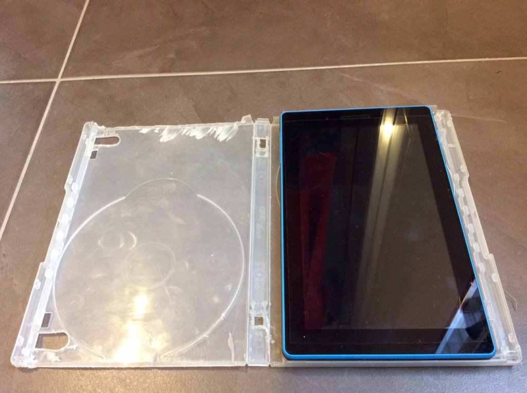
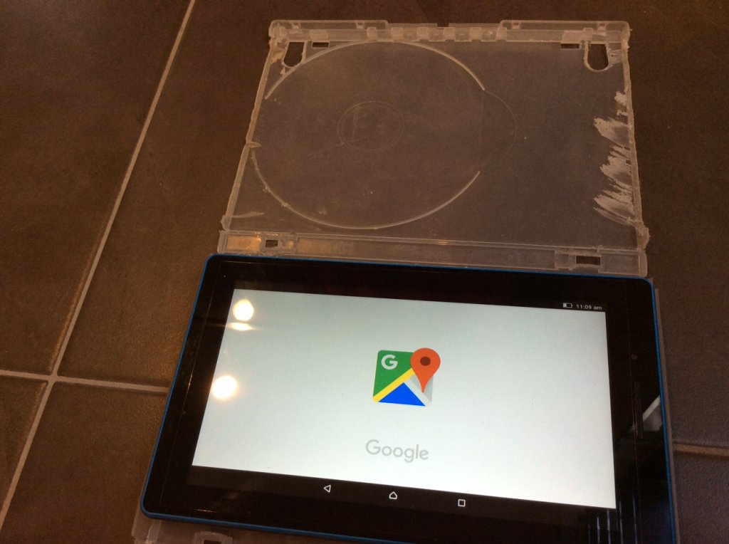
So today i bought a Lenovo 7inch tablet for $88. Eighty eight bucks are you serious!!! It has an inbuilt gps and works the same as the ipad did. Uses wifi (i won't bother with a SIM). Downloaded google maps and no have a neat, smaller (& less stress if it gets damaged) tablet. My home fix was to make a hard case from a dvd cover which with a bit of plastic grinding fits perfect.

ps i also take a gps and sat ph with me but this app is so easy and clear and has directed me up the right creek many times. You can mark areas when in wifi - BUT sometimes they don't show on the map when out of reception. I gps finds and put them on the map later in those cases.

stru
1498613362_img_0983.jpg

1498613362_img_0984.jpg
 
Good story :Y:

Good info - and now you don't mind being "up the creek" :lol:

I wish that I had a good hold on Gold prospecting and technology like you,maybe in the next life :cool:

Today I have learned something ;)

Thanks :)
 
I am watching this with keen interest as I will be travelling out to Harts range and Red Centre next year.. 8) . and I need something like this as we won't have much Reception on the phones or Computer... That's a good Tablet and a better price.... I have been looking at the Hema set-ups but they don't have all the tracks marked on the maps that you get...and for the $$ you pay for it... I would prefer something Else.... :rolleyes: and I think I would prefer a 10" screen as the Wolf's eyes aren't what they used to be... 8) :D

LW...
 
be aware LW that it remembers the maps for a certain period on time & i am not sure what that is as i use it daily. somebody mentioned 30days but i wouldn't rely on that. so if you on a long 'out of reception' trip it may stop working? you could always screen shot an area for reference but obviously you won't get the tracking blue dot!
 
Ok thanks for that Stru... Not Very Good for me then as it only holds the Maps for a while... Im after something that I can take my time and plan my trip out.. Planning to be out that way for 6-8 Weeks, so lots of things to put on the Maps.... MudMaps Were ok but have heard some bad reports now they have updated to MM2... or even MM3 now ?. and I think they use Hema maps now too.. A lot of people seem to use Ozzie Explorer as a base set-up, And im not too sure how this works or what maps you run on it.. but I do need something Easy to use. . My main issue that I have been coming across is, for Heavily Populated areas a lot of these 'Aps' will work great, but once you get into the less populated areas they aren't as good... or don't work at all... :( ... By the way, love the 'Tablet Case". :Y: ..

LW...
 
I use this navigation aid, it is somewhat unreliable during the night as the lights fail to turn on sometimes and bloody useless during the day as the glare tends to washout the image

I have used it on several occasions night detecting and have found it a trustful and cheap navigation companion. ;)

1498621295_image.jpg
 
I've got the Hema Explorer app and it is very good, only cost me about $40-00 and I can do an upgrade on a monthly basis to a much more detailed version for another $10-00.
I'm not affiliated with Hema in any way, just a happy user, and I'm also a believer in you only get what you pay for, you want good off line maps get the Hema app
cheers Keith
 
]:D I reckon that it would be 'Totally Useless' during the Day... Wally69... ]:D But worthy to know... you never know when you need it.. :Y:

LW...
 
xcvator Thanks , That sounds good.. I will look into that. :Y: .. I don't mind spending a few $$ to get something that serves its purpose well..

LW...
 
I have hema on android too & I find it good.
As a cheaper option I recently found "Australia Topo Maps" app on Google play. Won't work offline for the base app but you can upgrade to the Pro version for $12.99 which then gives you offline maps. Haven't fully tested it out yet but has a range of features including being able to upload your kmz/kml waypoints.
Might be worth a look using the free online version & if you decide it's ok upgrade to Pro.
P.s the NSW topo does have some more detail than the base Hema topo. Looks the same as Six Maps topo to me?
 
Hi you have my attention I am interested I am a old fart most comp stuff confuses me I do not have a smart phone it was smarter than me ,with this Lenovo thing do you have to connect it to the net when in the field how do you put the maps on it if some one can explain in layman's term I think there would be other out there like methanks regards john
 
Hi old hand, if it is the free google map maps you are refering to as in the first post, i'll re word it a little. The lenovo tablet has an inbuilt gps. once you buy it you need wifi. It actually comes with google maps installed i think so you just find the icon (can help you with that later) and click it. Map will appear and a blue dot will be your position on the screen. You click the screen on a little satellite image and then you are the good 'terrain' view with roads included. AFTER scanning around and viewing certain areas and zooming in etc you can view THESE same areas with the same clarity when you are with no reception/no wifi/no SIM card....middle of no where. When viewing the same areas/maps offline the blue dot still appears and moves etc. Beaware this device states 10hr battery life but i haven't tested that using the google maps offline. Didn't drain much battery on my ipad though.

One last pointer - these are not 'maps' as we used to know them old hand. This is a satellite image that you scroll around on screen. This free basic google maps will not have topographic lines etc although you can enter gps coordinates (a little tricky).
hope this helps
 
Stru just had a look at google maps will the satellite view work on your device as with that its easy to see the terrain ,it came up where I live when I googled google free maps .Sorry to be pain do I need wifi out in the bush or can I put maps on it at home and be able to use it in the bush thanks regards john :)
 
no worries old hand. you do not need wifi in the bush. as you say - view the area / maps at home before you go and you will see them in the bush. you can test this by looking at them with wifi then turning your wifi off...they'll still be viewable:)
 

Latest posts

Top