Tuning your Garmin

Prospecting Australia

Help Support Prospecting Australia:

This site may earn a commission from merchant affiliate links, including eBay, Amazon, and others.
Joined
May 4, 2014
Messages
1,034
Reaction score
1,195
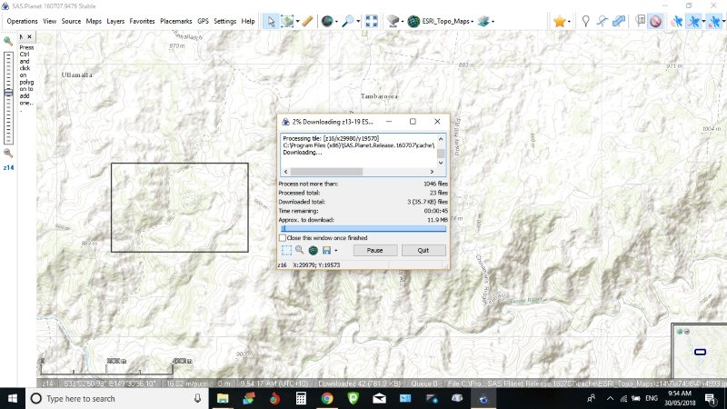
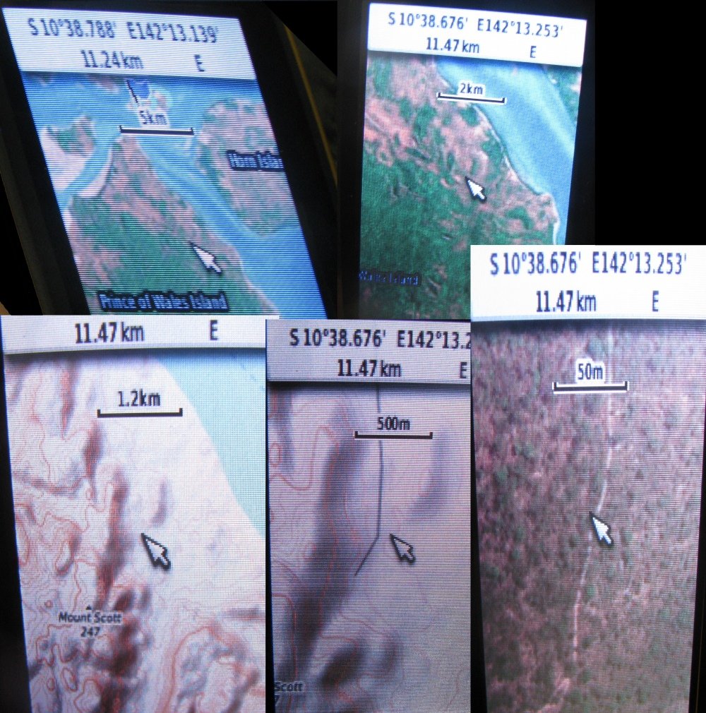
I have just finish tuning my Garmin 62 and thought others may be interested in doing so. It now has satellite imagery, topo maps and if I wish to, Navionics.

To do this the firmware has to be updated to a newer version that has been patched than what it is already running. Even if it has the latest version on it.

I have successfully done this to my Garmin. I'm not responsible for the results of everyone else's upgrades, including bricking. As they say "All care but no responsibility".

1- Down load the latest latest Garmin firmware from a link on this site. The reason I suggest this site is it show's what version are supported by the patcher and tested or supported, but not yet tested in a real device or not yet supported
http://whiter.brinkster.net/en/Versions.shtml

2- You need to then down load the patch, and unzip it. Then run the patch app (Firmwarepatcher 3.60).
If you are already running the latest firmware on your Garmin you will need to increase the firmware version. This is done, and it's obvious, in the patcher.
When you are ready just drag and drop the firmware (GPSMAP62_78_WebUpdater__690.gcd in my case) into the open patcher window. The firmware will now be patched and rewritten next to the original copy in the same folder. It will have the same name with the word 'patched' at the end.
https://yadi.sk/d/XObpd_ZT3Pw5RS

3- Next rename the new patched version of firmware to "Gupdate.gcd"

4 - And finally connect your Garmin and copy the new patched firmware to your 'Garmin' folder.

5- Disconnect your Garmin and turn on. Now it will automatically load up the patched firmware. Done.

You can now ready to make your own 'jnx' (Birdseye) files.
 
Is this a garmin upgrade or pirate type firmware ? I ask as mine does jnx map files ? Running shonky maps etc in it and also others as long as prefixed to a jnx file ............ standard garmin version 5 :/
 
ctxkid said:

To add what ever type maps you want. I'll do a how to make maps when I get some time to do the write up.

Weather it be satellite images - not Google Earth as the quality is bad. Use it to display navionics if you wish to go boating or a topo map. Although a topo map is limited to 25m contours. Or a combination - 20 and 30m zoom level could be a satellite image, and from then out topo maps.
As far as I can find out the Garmin Birdseye images are quite poor.

Bogger said:
Is this a garmin upgrade or pirate type firmware ? I ask as mine does jnx map files ? Running shonky maps etc in it and also others as long as prefixed to a jnx file ............ standard garmin version 5 hmm

The firmware has a patch applied to it that allows for home made jnx files, maps, satellite images, etc. to be added so it's genuine firmware that has had a patch applied. The patch was done by a third party.
Not sure how shonky do it because I was reading the Garmin checks to see if the file is a genuine Garmin file. The patch removes that part of the firmware -
unlocking the GPS.
From my reading Shonky use 50m contours not 25m.
 
Only as a layman I say this, but what I found as long as I named the file as a JNX file it would recognise and let me use it. Anything else it throws back as not recognised. But I believe that the 62 units prior to 2012 require more to run shonky maps. I've actually found shonky maps better than the garmin one's in some instances :eek:
 
Perhaps this is just a 62 thing but from trawling through all the forums I think it may be more widespread. :/ Alot of mention of a Birdseye license.
I'm also by passing Basecamp. No need for it.

Mine certainly wouldn't except any other JNX. Even a large KMZ it would not except until a program broke the file down to smaller tiles.

Just had a quick read up. Apparently the Garmin as standard will allow small JNX files but not the larger ones without a license.
 
That may be it now that you mention it .................. I usually only load in maps to the area I'm going. Small area with high detail and actually from memory the birdseye tells you when you have selected an area that it's size exceeds the file size limit :Y:
 
I can see this is going to take a while but:

Once you have patched your Garmin there are a few programs out there that will make apparently a JNX file. Mapc2mapc is one example although I couldn't get it too work.
However the one I use is a program called SASPlanet. http://www.sasgis.org/sasplaneta/ Yes, it is Russian but will open in English. Great program with the best satellite imagery and selection of maps I have found on the web. I used it here on this thread https://www.prospectingaustralia.com/forum/viewtopic.php?id=24452 to add satellite imagery to my Simrad.

My favorite maps of choice are Bing satellite, ESRI imagery and Navionics sonar chart. The ESRI Topo Maps (Not great but not bad).

What SASP does is takes the map you have selected and download the images required to build a multilevel map in the flavour you want KMZ, JNX, RMP, iPhone etc.

So once your map is chosen choose a zoom level (Note the bar on the left of the map, the 'Z#' is the zoom level). I suggest Z14 for this example. Then go to the drop down menu and select - Operations - Selection Manager - Rectangular Selection.
Now draw a rectangle of the area you want to have a map for. I suggest a small area to start off.

1527552187_selection..jpg


Next a window like this should open

1527552474_downloader.jpg
 
Before I go on it's probably best if I at least try and explain the zoom level (the Z# on the left of the screen and tiles) which is how 'zoomed' in you are on a map. Each zoom level given a number. The higher the Z# the closer in you are zoomed.

This is just an explanation not part of making this map or any other map.

I suggest going to - View, Tile Boundaries, Z14

When you select 'Z14' a load of square box's will be drawn on the screen. These box's are the individual image or tile that make up that zoom level of the map you are viewing. You will also see the selection you made earlier is made up of parts of four tiles or images (so it's four tiles as you can not use part tiles).

1527553940_tiles.jpg


Now if you went - View, Tile Boundaries, Z17
You would see how many tiles/images make up a map for the closer zoom level of Z17

1527554285_z17_zoom.jpg


Now we can see the selection is made up of 63 tiles (9 X 7). This happens with all the Z#'s. The higher the Z# the more tiles for any given area.

As I said this has nothing really to do with making the actual map. It's more to give an under standing of what on earth the program is doing. It also gives one an idea of how big a file will be as each individual tile of each chosen zoom level has to be downloaded and saved.
So if we only used Z14 and Z17 on our selection the program would download and save 67 different images. But in reality the image number is more likely to be in the 000's or 10's of 000's.
 
I do apologise for dragging this out but I'm a slow keyboard hunter and pecker. And it takes a bit to explain (Videos on it are pretty poor) plus I have work and the kids.

Anyway back to making the map of our selected area:
To make a zoom-able map of our selected area we have to down load all the whole tiles/images that the selection covers or partly covers in each individual zoom level that we want to use for our final map.
In this case I'd use zoom level Z13(as this covers the entire area with 1 tile) all the way up to z19. (z19 is usually the highest level of detail on a map.You should check weather before you start).
So we need to 'tick' each box in the 'zooms' column of the selection manager (lower image in post #9). Also you will see what map you are downloading. In my image it says "ESRI_Topo_Maps" And under that, as you tick each box a counter will count up the "Number of tiles: ----". That's the number of images it will download.

Now hit the start button and the following screen should appear.

1527639537_downloading.jpg


This tells you how many images it's trying to download, how many it's done and how many to go. It also tells you the size of the file. It is also worth noting once the file has been downloaded it is saved so can be reused for any future map making which makes the whole process a lot quicker.

Once the words "The task is completed!" appears in the window, close the window.

My little map consisted of 885 files/(images?) which was 2.4MB. I think the Garmin can take 100,000

Even though I haven't finished this tutorial it's probably worth down loading an area you may use later. Just so you have your hands on the setting up. The images will then be ready to use at a later date.
 
If any body has down loaded SASPlanet I have just found a way better Topo with 10m contours and far more detail regarding creeks, mines and tracks. It's under:
Maps - OSM - OpenTopoMap.org

Here's a link to the web site. https://opentopomap.org/#map=13/-33.02982/149.36454

I think I will use this map for my demo as the Grey contours on a white background on the ESRI topo maps are a bit hard to see on the Garmin screen. Plus these Open Topo maps have far more detail.
 
For the 'advanced' user:

If your'e trying this for the first time I would probably skip this post. It may add confusion. But if you think your ready to buff up the Topo with some added detail,, read on. This is just a suitable place to tack this bit on.

Once you are done closing the window as in post 11. Go back and change the map to a satellite image. I suggest: Maps - ESRI - ArcGIS.Imagery or Maps - Bing - Bing maps satellite.
And repeat what was done before. Except this time it's: Operations - Selection Manager - Last Selection.. Note,"Last selection". Download the tiles again from Z13 to Z19 (we won't use all of them but what the hell).

Once that is done it's back to standard JNX map making but with bells on.
 
Anyway computer/internet issues come and go.

This is what it achieves.
1528935845_garmin.jpg


Pretty dam handy. Especially v remote places like POW where the tracks are unmarked and seldom traveled. Just need SASPlanet and your Garmin firmware adjusted.
 
Dron said:
Thanks Mr Magoo, these instructions worked great for my GPSMAP62!

Damn. I hadn't finished as I thought there was so little interest it was a case of "I'll get round to it one day". So well done for figuring the rest out as it is a tricky to get some of the scaling done and I do apologies for leaving it unfinished. You have given me a bit more impetus to finish. :Y:

I did find that I think various map creators have possibly complained about copyright violation. So I suggest getting hold of SASPlanet 160707 from here https://bitbucket.org/sas_team/sas.planet.bin/downloads/ . I noticed some versions missed things like Navionics mapping otherwise, which you can also put on your Garmin.

Also found a way of getting around the KML limit to. So I'll address that also.

Thanks for the feed back. :)
 
I have a gpsmap60Cx. Do you think it will work with that Mr Magoo? I was not able to find it in the first link
 
shakergt said:
I have a gpsmap60Cx. Do you think it will work with that Mr Magoo? I was not able to find it in the first link

I would probably have to say a no if it's not in the 'firmware update' list in that first link.
 
Mr Magoo said:
If any body has down loaded SASPlanet I have just found a way better Topo with 10m contours and far more detail regarding creeks, mines and tracks. It's under:
Maps - OSM - OpenTopoMap.org

Here's a link to the web site. https://opentopomap.org/#map=13/-33.02982/149.36454

I think I will use this map for my demo as the Grey contours on a white background on the ESRI topo maps are a bit hard to see on the Garmin screen. Plus these Open Topo maps have far more detail.

This map has more detail than my garmin Oztopo map. be nice to have the whole of Australia in this map on my gps
 

Latest posts

Top