You are using an out of date browser. It may not display this or other websites correctly.
You should upgrade or use an alternative browser.
You should upgrade or use an alternative browser.
Cyclones
- Thread starter LONEWOLF
- Start date


Help Support Prospecting Australia:
This site may earn a commission from merchant affiliate
links, including eBay, Amazon, and others.
Any of our members up where cyclone Trevor is atm ?
Unsure, but our friends at the Palmer Goldfields (Brother, Diggerman60, and Simmo) would have caught a drenching as it passed!
At least they'll have full dams for their gold wash plants!
At least they'll have full dams for their gold wash plants!
Hopefully she wont give you any trouble MT!
Australian Government Bureau of Meteorology
Northern Territory
Tropical Cyclone Warning Centre
Media: The Standard Emergency Warning Signal should NOT be used with this warning.
TOP PRIORITY FOR IMMEDIATE BROADCAST
TROPICAL CYCLONE WARNING
CORRECTED TROPICAL CYCLONE ADVICE NUMBER 50 (CORRECTED QLD RECOMMENDED ACTIONS)
Issued at 5:35 pm ACST [6:05 pm AEST] on Saturday 23 March 2019
Headline:
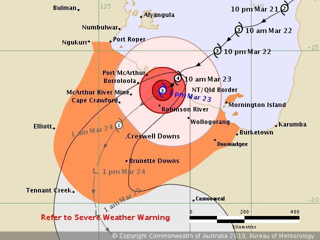
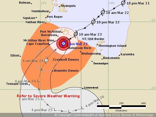
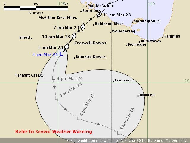
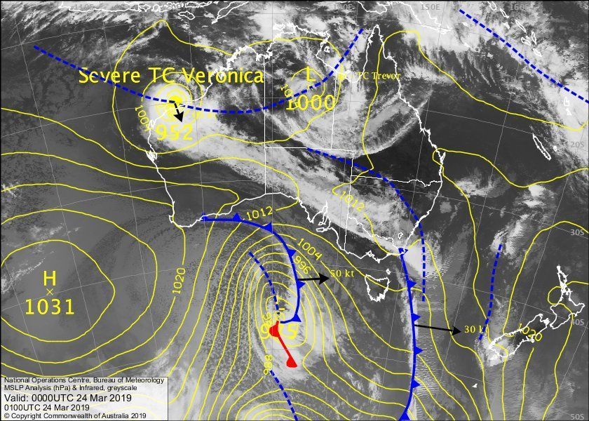
The centre of Severe Tropical Cyclone Trevor is located over land between Borroloola and the NT/Qld border. Dangerous conditions will extend further inland during tonight.
Areas Affected:
Warning Zone
Nathan River in the Northern Territory to Mornington Island in Queensland (but not including Mornington Island), and inland parts of the Carpentaria District, Barkly District and the northwest Gulf Country, including Borroloola, Robinson River, Wollogorang, McArthur River, Cape Crawford, Creswell Downs and Brunette Downs.
Watch Zone
None.
Cancelled Zone
Port Roper to Nathan River in NT and Mornington Island to Burketown, including Doomadgee in Qld..
Details of Severe Tropical Cyclone Trevor at 3:30 pm ACST [4:00 pm AEST]:
Intensity: Category 3, sustained winds near the centre of 120 kilometres per hour with wind gusts to 165 kilometres per hour.
Location: within 45 kilometres of 16.6 degrees South 136.7 degrees East, estimated to be 70 kilometres southeast of Borroloola and 260 kilometres west of Mornington Is.
Movement: southwest at 21 kilometres per hour.
Severe Tropical Cyclone Trevor was located inland over the Carpentaria District east of Cape Crawford. The very destructive core is expected to weaken further as it moves into the Barkly District overnight. The system is expected to weaken below cyclone strength during Sunday morning west of Brunette Downs.
Hazards:
The VERY DESTRUCTIVE core of Severe Tropical Cyclone Trevor is moving inland over the Carpentaria District between Borroloola and the NT/Qld border. Gusts to 165 km/h near the cyclone centre, gradually easing as the cyclone moves further inland.
DESTRUCTIVE winds, with gusts to 130 km/hr are occurring within 60 kilometres of the cyclone centre and will extend inland to the Cape Crawford area this evening.
Coastal residents between Port McArthur and the NT/Qld Border are specifically warned of a VERY DANGEROUS STORM TIDE as the cyclone moves inland. Tides will remain significantly above the normal high tide this evening and Sunday morning, with DAMAGING WAVES and VERY DANGEROUS FLOODING continuing overnight.
As the cyclone moves inland, a STORM TIDE is also expected between the NT/QLD border and Burketown. Large waves may produce minor flooding along the foreshore. People living in areas likely to be affected by this flooding should take measures to protect their property as much as possible and be prepared to help their neighbours.
GALES, with gusts to 100 km/h are occurring on the mainland coast between Nathan River in the Northern Territory and Mornington Island in Queensland and inland over the Carpentaria District. GALES are expected to extend further inland into the northern Barkly District overnight. Inland locations which may be affected tonight and early Sunday include Creswell Downs, Cape Crawford, Robinson River, McArthur River, Wollogorang and Brunette Downs.
HEAVY RAINFALL is likely to cause significant stream rises and localised flooding in the eastern Carpentaria District tonight and tomorrow. A Flood Watch has been issued for Carpentaria Coastal Rivers and the Barkly in the Northern Territory.
HEAVY RAINFALL will also develop over the western Gulf Country in Queensland as the cyclone moves inland. Flood Warnings are current in Queensland for the Daintree and Mossman Rivers, as well as a broader Flood Watch for catchments north of Cairns to Kowanyama, the western Gulf Country, and the Channel Country.
Recommended Action:
NTES advises:
Residents from Nathan River to NT/Qld border, including and Borroloola and inland areas of the Carpentaria and Barkly Districts
-Follow direction and advice of local emergency services;
-Residents in the Warning Area should prepare for severe weather, increase in damaging winds and rain and are to take shelter as conditions deteriorate.
QLD SES advises:
People between the NT/Qld border and Mornington Island (but not including Mornington Island), and adjacent inland areas, should remain inside until the cyclone has passed and listen to the next advice.
- Information is available from your local government.
- For cyclone preparedness and safety advice, visit Queensland's Disaster Management Services website (www.disaster.qld.gov.au).
- For emergency assistance call the Queensland State Emergency Service (SES) on 132 500 (for assistance with storm damage, rising flood water, fallen trees on buildings or roof damage).
Further advice on cyclone emergencies is available at www.securent.nt.gov.au. Please ensure that friends, family and neighbours have heard and understood this message, particularly new arrivals to the area.
Next Advice:
The next advice will be issued by 8:00 pm ACST Saturday 23 March [8:30 pm AEST Saturday 23 March].
This advice is available on telephone NT-1300 659 211 and QLD-1300 659 212
A map showing the track of the cyclone is available at: http://www.bom.gov.au/cyclone
Northern Territory
Tropical Cyclone Warning Centre
Media: The Standard Emergency Warning Signal should NOT be used with this warning.
TOP PRIORITY FOR IMMEDIATE BROADCAST
TROPICAL CYCLONE WARNING
CORRECTED TROPICAL CYCLONE ADVICE NUMBER 50 (CORRECTED QLD RECOMMENDED ACTIONS)
Issued at 5:35 pm ACST [6:05 pm AEST] on Saturday 23 March 2019
Headline:
The centre of Severe Tropical Cyclone Trevor is located over land between Borroloola and the NT/Qld border. Dangerous conditions will extend further inland during tonight.
Areas Affected:
Warning Zone
Nathan River in the Northern Territory to Mornington Island in Queensland (but not including Mornington Island), and inland parts of the Carpentaria District, Barkly District and the northwest Gulf Country, including Borroloola, Robinson River, Wollogorang, McArthur River, Cape Crawford, Creswell Downs and Brunette Downs.
Watch Zone
None.
Cancelled Zone
Port Roper to Nathan River in NT and Mornington Island to Burketown, including Doomadgee in Qld..
Details of Severe Tropical Cyclone Trevor at 3:30 pm ACST [4:00 pm AEST]:
Intensity: Category 3, sustained winds near the centre of 120 kilometres per hour with wind gusts to 165 kilometres per hour.
Location: within 45 kilometres of 16.6 degrees South 136.7 degrees East, estimated to be 70 kilometres southeast of Borroloola and 260 kilometres west of Mornington Is.
Movement: southwest at 21 kilometres per hour.
Severe Tropical Cyclone Trevor was located inland over the Carpentaria District east of Cape Crawford. The very destructive core is expected to weaken further as it moves into the Barkly District overnight. The system is expected to weaken below cyclone strength during Sunday morning west of Brunette Downs.
Hazards:
The VERY DESTRUCTIVE core of Severe Tropical Cyclone Trevor is moving inland over the Carpentaria District between Borroloola and the NT/Qld border. Gusts to 165 km/h near the cyclone centre, gradually easing as the cyclone moves further inland.
DESTRUCTIVE winds, with gusts to 130 km/hr are occurring within 60 kilometres of the cyclone centre and will extend inland to the Cape Crawford area this evening.
Coastal residents between Port McArthur and the NT/Qld Border are specifically warned of a VERY DANGEROUS STORM TIDE as the cyclone moves inland. Tides will remain significantly above the normal high tide this evening and Sunday morning, with DAMAGING WAVES and VERY DANGEROUS FLOODING continuing overnight.
As the cyclone moves inland, a STORM TIDE is also expected between the NT/QLD border and Burketown. Large waves may produce minor flooding along the foreshore. People living in areas likely to be affected by this flooding should take measures to protect their property as much as possible and be prepared to help their neighbours.
GALES, with gusts to 100 km/h are occurring on the mainland coast between Nathan River in the Northern Territory and Mornington Island in Queensland and inland over the Carpentaria District. GALES are expected to extend further inland into the northern Barkly District overnight. Inland locations which may be affected tonight and early Sunday include Creswell Downs, Cape Crawford, Robinson River, McArthur River, Wollogorang and Brunette Downs.
HEAVY RAINFALL is likely to cause significant stream rises and localised flooding in the eastern Carpentaria District tonight and tomorrow. A Flood Watch has been issued for Carpentaria Coastal Rivers and the Barkly in the Northern Territory.
HEAVY RAINFALL will also develop over the western Gulf Country in Queensland as the cyclone moves inland. Flood Warnings are current in Queensland for the Daintree and Mossman Rivers, as well as a broader Flood Watch for catchments north of Cairns to Kowanyama, the western Gulf Country, and the Channel Country.
Recommended Action:
NTES advises:
Residents from Nathan River to NT/Qld border, including and Borroloola and inland areas of the Carpentaria and Barkly Districts
-Follow direction and advice of local emergency services;
-Residents in the Warning Area should prepare for severe weather, increase in damaging winds and rain and are to take shelter as conditions deteriorate.
QLD SES advises:
People between the NT/Qld border and Mornington Island (but not including Mornington Island), and adjacent inland areas, should remain inside until the cyclone has passed and listen to the next advice.
- Information is available from your local government.
- For cyclone preparedness and safety advice, visit Queensland's Disaster Management Services website (www.disaster.qld.gov.au).
- For emergency assistance call the Queensland State Emergency Service (SES) on 132 500 (for assistance with storm damage, rising flood water, fallen trees on buildings or roof damage).
Further advice on cyclone emergencies is available at www.securent.nt.gov.au. Please ensure that friends, family and neighbours have heard and understood this message, particularly new arrivals to the area.
Next Advice:
The next advice will be issued by 8:00 pm ACST Saturday 23 March [8:30 pm AEST Saturday 23 March].
This advice is available on telephone NT-1300 659 211 and QLD-1300 659 212
A map showing the track of the cyclone is available at: http://www.bom.gov.au/cyclone
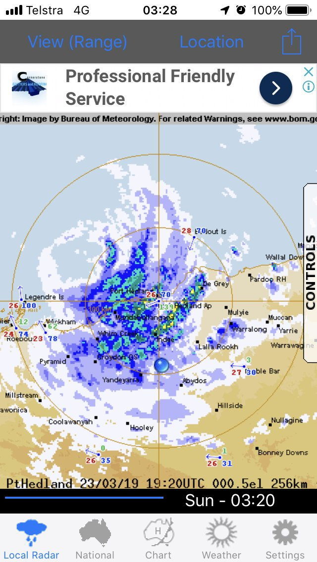
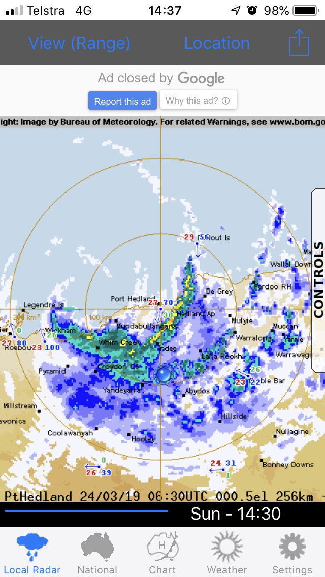
I noticed the strongest wind gust at Borroloola was 139klm at 0930 yesterday.
Ec Cyclone Trevor is a tropical low - still lottsa rain.
- Joined
- Mar 10, 2016
- Messages
- 7,947
- Reaction score
- 16,016
All the best to everyone having to put up with this. News reports say the Mayor of Port Headland says people aren't prepared  that won't help if that's the case.
that won't help if that's the case.well Trevor has blown himself out.
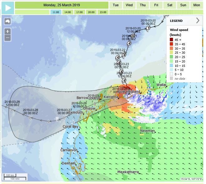
And Veronica is rapidly running out of puff too .. anticliamx, has spared the Pilbara a big mess.
And Veronica is rapidly running out of puff too .. anticliamx, has spared the Pilbara a big mess.
Yep been locked up since Saturday in the dongas
Listening to the wind and rain
Got let out yesterday morning for some tucker and the same this morning
Have a meeting later today for a state of play report
Then work as usual tomorrow
Still windy and raining but we are well on the back of the cyclone
It of water laying round and the creek is flowing
Similar threads
- Replies
- 15
- Views
- 7K