Prospecting Crown Land Victoria information and questions

Prospecting Australia

Help Support Prospecting Australia:

This site may earn a commission from merchant affiliate links, including eBay, Amazon, and others.

mozzie1957

Wayne Blyton
Joined
Oct 31, 2013
Messages
204
Reaction score
94
Location
Junortoun, VIC
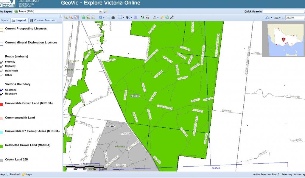
I have a question about prospecting on Unreserved Crown Land that is held under just a General licence.
The land in question has a dirty great 'Keep Out' sign on it. It's a parcel of unreserved crown that someone
has seen fit to take a general licence on and now refuses to allow access to an area that used to be open.

Yet the following is from the Dept of Many Name Changes (DSE) own fact sheet on managing Crown Land:

If I hold a Crown land licence, do I have the right to exclude others from the licence area?
No. A licence does not convey any exclusive rights to the licensee.


So, can I enter and tell any that try to stop me to 'Bugger off'? Politely of course. And while armed with a
copy of this fact sheet.
 
I would contact the licensee, if possible, & make sure that they do only have a general licence firstly. If so you are well within your rights to access & the sign would be illegally placed but tread lightly IMO. I have a similar situation with some crown land in NSW but haven't pushed the issue as yet.
If they have upgraded & taken out a lease, giving them exclusive rights to land use, then you will need their permission. Either way it couldn't hurt to talk to the licensee/leasee & tell them what your doing + politely point out your right of access if they still only have a general licence.
 
To all the Members in or around the Triangle - is there a quick way that I might be able to get list of the Crown land in the Golden Triangle of Victoria? I have googled "Crown Land Victoria" but cant really make heads or tails of it all. It seems I may have to go to some government or land office or such like, but as I say cant make heads or tails of it all. Can anyone help? Off to the goldfields in a couple of weeks. Any help would be appreciated. Thanks TD
 
From what I've gleaned from Vicparks and my Vicmap topo maps, here's my 2 bobs worth.

There are State Forrests, State Parks, National Parks, Historical Parks, Conservation Parks and Flaura and Fauna Parks. I may have missed some.

From what I can see although most if not all of the above are Crown Land, not all Crown Land is available for prospecting. An Example is the Paddys Ranges Park, imediately to the north of Karri Track Campground is conservation and not available, the area to the south to Amherst is. Another - St Arnaud from the town to Teddington Weir is called the St Arnaud Range National Park. But Parks Vic state on their mudmap that from the weir to Carpooee is available for prospecting, but from Carapooee to St Arnaud is not.

What is confusing is, that I along with others are of the belief that all Crown land is detectable, but Parks Vic say it's not.

Perhaps someone like Loamer or other long time prospectors can clarify for both of us. Pleading ignorance may get a warning, but it could also get a fine and confiscation of equipment.
 
Hi TD, just go to http://nremap-sc.nre.vic.gov.au/MapShare.v2/imf.jsp?site=forestexplorer
and read a tad on how to use it.
Select an area then select what you wish to show.

IE

1392537613_forest_ex.jpg
 
Hi TD, Generally speaking stay off the darker green shaded areas because it's okay to prospect in some but not others depending on whereabouts they are in the state - so treat them areas as a minefield :/ . There is a heritage overlay that you should enable as well as there a few protected locations in your area of interest that will be signified by yellow borders. One is puddler site and you might well stumble on other smaller puddlers in your meanderings and we tend not to detect or dig in them to preserve them.

good luck

casper
 
Thanks Redfin, that gives me a bit more to add to the docs. The ATX is going to be working OT while we are over in Vic so I don't want to be stuffing around just haphazardly trying here and trying there. Thanks to you both. Let you know how I go when we get back. And if I come up with a nugget, you'll hear the Eu-bloody-reka probably from your place.
 
Give the depi office a call in advance if you have trouble with the mapping, any grey areas will quickly be cleared up, i went in a spent half an hour clarifying a couple of spots i was looking at they were very helpful. Saves guessing and answering to the authorities in the field. They even got out the yellow highlighter!
 
Use 'geovic' (google the term) but here is a link http://er-info.dpi.vic.gov.au/sd_weave/anonymous.html and set the legend for crown land - usually its grey. You can also go to the Vic parks website and check all the parks individually - it will show you what is and is not allowed to be prospected - they also have free maps which are excellent. Most of the crown land in the golden triangle is available for prospecting with the exceptions listed in the Miners Rights 'FAQ' part of the website (google Miners rights FAQ).

Some areas are off-limits for conservation matters, heritage matters etc. It still leaves a huge area open for prospecting that is historically very rich and still producing. All forests are off-limits on catastrophic fire ban days.

Here is crown land example from geovic. It can take a bit of time to learn how to use but you can use it to make your own maps - has lease overlays, gold, topo data etc etc. Very good and its free. You can cover the whole state if you want - has water courses etc but there is a distinct lack of water at the moment for panning etc.

1392550541_adddd.jpg
 
Below is the link to Parkweb showing St Arnaud, It clearly shows where prospecting can occur, I'm assuming the rest of the Park is nogo, otherwise there's no point in defining the prospecting area.

Parkweb have PDFs for all the listed approved prospecting areas, but, not all the maps define prospecting areas and not all parks where people detect are listed. So to a newbie it's confusing

http://parkweb.vic.gov.au/__data/as...3/Park-note-St-Arnaud-Range-National-Park.pdf.

I've also gone to the maps noted by Redfin and it shows the parks around Maryborough, but doesn't define an area in a Park I know of, that is off limits to prospecting. Kinda tells me there's not a "one stop shop". So on my last trip I went to the Parks office in Maryborough, the lady in their office couldn't tell me what was ok or not. Also that there were 2 Rangers, one was on leave and the other was out of office and was pretty busy. That told me they were spread pretty thin and didn't answer my question.

I got most sense from the guys at Coiltek as to where I could go or not.
 
Maryborough - Parts of Paddys Ranges are off limits - they are wildflower reserves. DPI have the info.
 
Thanks to you all. I am truly indebted to you all. Because I live in SA I'm not really up with all the stuff you need to know. But with all you info I will become very acquainted. Redfin, we will be in Ballarat from about the 3rd to the 13th of Mar, [a 10day stay at a caravan park powered site auction] If youre around be great to catch up. Will talk again soon.
 
No worries mate - its a very good free service - pretty accurate too. Once you get the hang of it it is pretty straight forward. The great thing is you can make your own maps.
 
1421811792_geovic.jpg


Just wondering if anyone knows if I can detect on restricted crown land MRSDA? Is this restriction for mining or apply to recreational prospecting as well? If any one has any info that would be great as I have looked around on the web for a while but didn't get anything of value.

Cheers

Dan
 
If you are referring to the larger green area on the above map, that is the Havelock Nature Conservation Reserve.

My understanding is that we can not detect Nature Conservation Areas, but I'll stand corrected if I'm wrong.

Do a search on Parks Web, it may tell you, if not send them a message and get the right info.
 
i detect anywhere that i do not think is private land , an if wrong , they only have to ask me to leave, fill ya hole an move on
 
Yep just found it, it is the nature conservation reserve I'll shoot parks vic an email and see what they say :)
 

Latest posts

Top