- Joined
- Mar 24, 2018
- Messages
- 398
- Reaction score
- 454
https://minview.geoscience.nsw.gov....5601120992&lon=-32.363292890435865&z=6&bm=bm1
try this, Dunno if it will work or not
try this, Dunno if it will work or not


Current list as at 27/08/18220 said:No luck finding a current list of NSW fossicking areas (someone else might have better google-fu) but media release from Dec states 21.4% state is now declared.
Sorry post count isn't high enough to post links.
This will come in handy for my trip over Xmas thanksmbasko said:NSW research sites:
http://minview.minerals.nsw.gov.au/mv2web/mv2
http://nswtitles.minerals.nsw.gov.au/nswtitles/
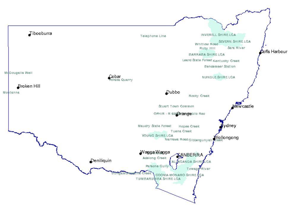
Fossicking Districts
Within a fossicking district, a person can go onto an exploration licence for the purpose of fossicking without the licence holder's consent, provided they have the permission of the landholder. A fossicking district may cover a small area, or an entire shire.
https://www.prospectingaustralia.com/forum/img/member-images/4485/1431167302_capture.jpg
NSW Fossicking Districts
TUMBARUMBA SHIRE LGA 7 L98/0394 Notified at the request of Tumbaruma Council
COOMA-MONARO SHIRE LGA 5 L98/0394 Notified at the request of Cooma-Monaro Council
TALLAGANDA SHIRE LGA 8 L98/0394 Notified at the request of Tallaganda Council
YOUNG SHIRE LGA 6 L98/0394 Notified at the request of Young Council
SEVERN SHIRE LGA 2 T97/0535 Notified at the request of Severn Council
BARRABA SHIRE LGA 9 L99/0610 Notified at the request of Barraba Shire Council
NUNDLE SHIRE LGA
INVERELL SHIRE LGA
OPHIR - R 65909 for Public Rec 1 L97/0303 Notified at the request of Cabonne Council over Reserve No 65909 for Pub Rec
Campbells River 10 M92/0417 Former Fossicking Area No 4
Abercrombie Caves 11 M92/0417 Former Fossicking Area No 5 M74/3530
Sofala Common 12 M92/0417 Former Fossicking Area No 8 M74/3530
Blackguard Gully 13 M92/0417 Former Fossicking Area No 10 M75/4551
Abercrombie River 14 M92/0417 Former Fossicking Area No 14 M75/4547
Tuena Creek 15 M92/0417 Former Fossicking Area No 17 M78/2177
McDougalls Well 16 M92/0417 Former Fossicking Area No 18
Rocky Creek 17 M92/0417 Former Fossicking Area No 19
Sara River 18 M92/0417 Former Fossicking Area No 20
Bora Creek 19 M92/0417 Former Fossicking Area No 24
Kentucky Creek 20 M92/0417 Former Fossicking Area No 25
Telephone Line 21 M92/0417 Former Fossicking Area No 29
Adelong Creek 22 M92/0417 Former Fossicking Area No 32 M75/3567
Tambaroora 23 M92/0417 Former Fossicking Area No 34 M75/2475
Ruby Hill 24 M92/0417 Former Fossicking Area No 35
Bodalla State Forest 25 M92/0417 Former Fossicking Area No 38
Jones Swamp Gully 26 M92/0417 Former Fossicking Area No 39 M74/4225
Montanna 27 M92/0417 Former Fossicking Area No 40
Whitlow Road 28 M92/0417 Former Fossicking Area No 41
Grabben Gullen Creek 29 M92/0417 Former Fossicking Area No 42
Grabben Gullen Creek 30 M92/0417 Former Fossicking Area No 43
Grabben Gullen Creek 31 M92/0417 Former Fossicking Area No 44
Hopes Creek 32 M92/0417 Former Fossicking Area No 46 M75/3518
Hopes Creek 33 M92/0417 Former Fossicking Area No 47 M75/3518
Hopes Creek 34 M92/0417 Former Fossicking Area No 48 M75/3518
Long Creek 35 M92/0417 Former Fossicking Area No 49
Poraka Quarry 36 M92/0417 Former Fossicking Area No 52
Poor Mans Gully 37 M92/0417 Former Fossicking Area No 55
Stuart Town Common 38 M92/0417 Former Fossicking Area No 56
Stuart Town Common 39 M92/0417 Former Fossicking Area No 57
Tumbarumba Creek 40 M92/0417 Former Fossicking Area No 58
Leard State Forest 41 M92/0417 Former Fossicking Area No 61
Gibbergunyah Creek 42 M92/0417 Former Fossicking Area No 62
Yarrow River Bridge 44 M92/0417 Former Fossicking Area No 64
Bungambrawatha Creek 45 M92/0417 Former Fossicking Area No 65
Bendemeer Station 46 M92/0417 Former Fossicking Area No 66
Waterfall Creek 47 M92/0417 Former Fossicking Area No 67
Waterfall Creek 48 M92/0417 Former Fossicking Area No 68
Riverside 49 M92/0417 Former Fossicking Area No 69
Maudry State Forest 50 M92/0417 Former Fossicking Area No 70
Parsons Gully 51 M92/0417 Former Fossicking Area No 71
Golden Gully 52 M92/0417 Former Fossicking Area No 72 M79/0347
Tomaga River 53 M92/0417 Former Fossicking Area No 73 M80/3580
Source: http://minview.minerals.nsw.gov.au/mv2web/mv2
Duffman said:This will come in handy for my trip over Xmas thanksmbasko said:NSW research sites:
Fossicking Districts
Within a fossicking district, a person can go onto an exploration licence for the purpose of fossicking without the licence holder's consent, provided they have the permission of the landholder. A fossicking district may cover a small area, or an entire shire.
http s://www.prospectingaustralia.com/forum/img/member-images/4485/1431167302_capture.jpg
NSW Fossicking Districts
TUMBARUMBA SHIRE LGA 7 L98/0394 Notified at the request of Tumbaruma Council
COOMA-MONARO SHIRE LGA 5 L98/0394 Notified at the request of Cooma-Monaro Council
TALLAGANDA SHIRE LGA 8 L98/0394 Notified at the request of Tallaganda Council
YOUNG SHIRE LGA 6 L98/0394 Notified at the request of Young Council
SEVERN SHIRE LGA 2 T97/0535 Notified at the request of Severn Council
BARRABA SHIRE LGA 9 L99/0610 Notified at the request of Barraba Shire Council
NUNDLE SHIRE LGA
INVERELL SHIRE LGA
OPHIR - R 65909 for Public Rec 1 L97/0303 Notified at the request of Cabonne Council over Reserve No 65909 for Pub Rec
Campbells River 10 M92/0417 Former Fossicking Area No 4
Abercrombie Caves 11 M92/0417 Former Fossicking Area No 5 M74/3530
Sofala Common 12 M92/0417 Former Fossicking Area No 8 M74/3530
Blackguard Gully 13 M92/0417 Former Fossicking Area No 10 M75/4551
Abercrombie River 14 M92/0417 Former Fossicking Area No 14 M75/4547
Tuena Creek 15 M92/0417 Former Fossicking Area No 17 M78/2177
McDougalls Well 16 M92/0417 Former Fossicking Area No 18
Rocky Creek 17 M92/0417 Former Fossicking Area No 19
Sara River 18 M92/0417 Former Fossicking Area No 20
Bora Creek 19 M92/0417 Former Fossicking Area No 24
Kentucky Creek 20 M92/0417 Former Fossicking Area No 25
Telephone Line 21 M92/0417 Former Fossicking Area No 29
Adelong Creek 22 M92/0417 Former Fossicking Area No 32 M75/3567
Tambaroora 23 M92/0417 Former Fossicking Area No 34 M75/2475
Ruby Hill 24 M92/0417 Former Fossicking Area No 35
Bodalla State Forest 25 M92/0417 Former Fossicking Area No 38
Jones Swamp Gully 26 M92/0417 Former Fossicking Area No 39 M74/4225
Montanna 27 M92/0417 Former Fossicking Area No 40
Whitlow Road 28 M92/0417 Former Fossicking Area No 41
Grabben Gullen Creek 29 M92/0417 Former Fossicking Area No 42
Grabben Gullen Creek 30 M92/0417 Former Fossicking Area No 43
Grabben Gullen Creek 31 M92/0417 Former Fossicking Area No 44
Hopes Creek 32 M92/0417 Former Fossicking Area No 46 M75/3518
Hopes Creek 33 M92/0417 Former Fossicking Area No 47 M75/3518
Hopes Creek 34 M92/0417 Former Fossicking Area No 48 M75/3518
Long Creek 35 M92/0417 Former Fossicking Area No 49
Poraka Quarry 36 M92/0417 Former Fossicking Area No 52
Poor Mans Gully 37 M92/0417 Former Fossicking Area No 55
Stuart Town Common 38 M92/0417 Former Fossicking Area No 56
Stuart Town Common 39 M92/0417 Former Fossicking Area No 57
Tumbarumba Creek 40 M92/0417 Former Fossicking Area No 58
Leard State Forest 41 M92/0417 Former Fossicking Area No 61
Gibbergunyah Creek 42 M92/0417 Former Fossicking Area No 62
Yarrow River Bridge 44 M92/0417 Former Fossicking Area No 64
Bungambrawatha Creek 45 M92/0417 Former Fossicking Area No 65
Bendemeer Station 46 M92/0417 Former Fossicking Area No 66
Waterfall Creek 47 M92/0417 Former Fossicking Area No 67
Waterfall Creek 48 M92/0417 Former Fossicking Area No 68
Riverside 49 M92/0417 Former Fossicking Area No 69
Maudry State Forest 50 M92/0417 Former Fossicking Area No 70
Parsons Gully 51 M92/0417 Former Fossicking Area No 71
Golden Gully 52 M92/0417 Former Fossicking Area No 72 M79/0347
Tomaga River 53 M92/0417 Former Fossicking Area No 73 M80/3580
Source: htt p://minview.minerals.nsw.gov.au/mv2web/mv2
mbasko said:The former fossicking areas were just changed over to fossicking districts under newer legislation i.e. Former fossicking Area no. 64 is now known as Yarrow River Bridge 44 M92/0417.
Still open to fossicking if NSW Fossicking Guidelines are followed.
A lot are now covered in wider Shire LGA Fossicking Districts too.
Enter your email address to join: