(WA) Western Australia Tengraph information and questions

Prospecting Australia

Help Support Prospecting Australia:

This site may earn a commission from merchant affiliate links, including eBay, Amazon, and others.
Joined
Apr 11, 2015
Messages
3
Reaction score
0
I'm hoping somebody can help me out.
I would like to find a way of using tengraph so that I can plot and mark tenements on to paper maps so that I know that I'm not on somebody's claim, I have a Magellan explorist GPS 610 and I have bought a couple of topo maps of Laverton and Leonora.
I'm used to using a compass with a map and protractor from my army days but to my absolute confusion I found the maps are using GPS coordinates and I really don't have any idea how to read from the GPS and use them in conjunction with the map and from Tengraph.
I will be honest and say this system has blown the few brain cells I have, so any help on any of the above would be greatly appreciated.

Thanks in advance I hope.
 
How are you getting the Tenements ? What software are you using. If you haven't used it, go and look at Geoview/Geomap it will make your life a lot easier than using tengraph. I run courses on these so keep an eye out if you would like to attend one, it covers using this software and referencing in the field.

Geomap can be connected to your GPS to give live tracking in the bush so you absolutely know if you are on someones tenement or not and does not rely on an internet connection.
 
thanks Westaus
I'm just using Tengraph from the DMP sitting trying to cross reference wit google maps and paper maps but as you can imagine its not very accurate and GPS coordinates confuse the hell out of me especially as there is more than one format, really not sure which one to use.

but thanks for your reply I will have a look at Geomap and I will also have a look at your face book page and may have to take one of your courses because iM itching to get out to the goldfields as soon as possible
 
I can't speak for the Magellan, I use Garmin, but, most GPS units can be set to LAT/LON or GRID, just set it to the same as your maps. If you mark tracks or waypoints in either coordinate system, then change to the other they are still there and the position is converted to the next system you use.
 
condor22 said:
I can't speak for the Magellan, I use Garmin, but, most GPS units can be set to LAT/LON or GRID, just set it to the same as your maps. If you mark tracks or waypoints in either coordinate system, then change to the other they are still there and the position is converted to the next system you use.

Yes that is a way and it works, but if you need to do a lot of tenements it doesn't really work well. For a couple yes I would do this.

Detrack said:
Will maps like this help
Have put the Current WA EL Pending Lease on the Leonora 250K geomap and topomap
Do you have a fast internet this file is 148MB
https://drive.google.com/file/d/0B-WiYXamgm1DbEwwTWZZRER6cWM/view?usp=sharing
:lol:

I will be interested to see as well, downloading now, thanks.

hucdj said:
thanks Westaus
I'm just using Tengraph from the DMP sitting trying to cross reference wit google maps and paper maps but as you can imagine its not very accurate and GPS coordinates confuse the hell out of me especially as there is more than one format, really not sure which one to use.

but thanks for your reply I will have a look at Geomap and I will also have a look at your face book page and may have to take one of your courses because iM itching to get out to the goldfields as soon as possible

The Facebook page is for my Safety Business, however I have just started a Youtube channel to which I will be adding how to videos and other things. So keep an eye out for that.

This is the link with the course details but interest has been slow, so not sure if it will go ahead but some details for you to look over https://www.prospectingaustralia.com/forum/viewtopic.php?id=11138
 
thanks fellas
Westaus whilst looking up Geomap I found this,http://geodownloads.dmp.wa.gov.au/datacentre/datacentreDb.asp
it gives you layers of all current tenements in W.A and a few other layer to go on to google maps which kind of help me in one area but I'm still a bit stumped not how to read or rather make sense of coordinates from GPS to the paper map but after reading yours posts as well Condor and Detrack I reckon I should have enough to keep me occupied for days.
thanks again guys I really do appreciate all help

Hucdj
 
No worries hucdj you are on the right track for sure.

I would encourage the initial use of Geoview as it is a simple click layers and add what you want to see. This will not assist initially in your GPS adding of plots etc... However you can use the grids as a guide to make sure you are not in an area you shouldn't be as example -

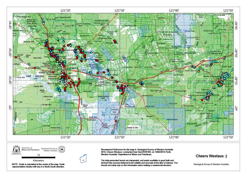
250K topo with current tenements - + Old abandoned mines inventory :)

1429113049_leonora_2015-04-15_tenements.jpg


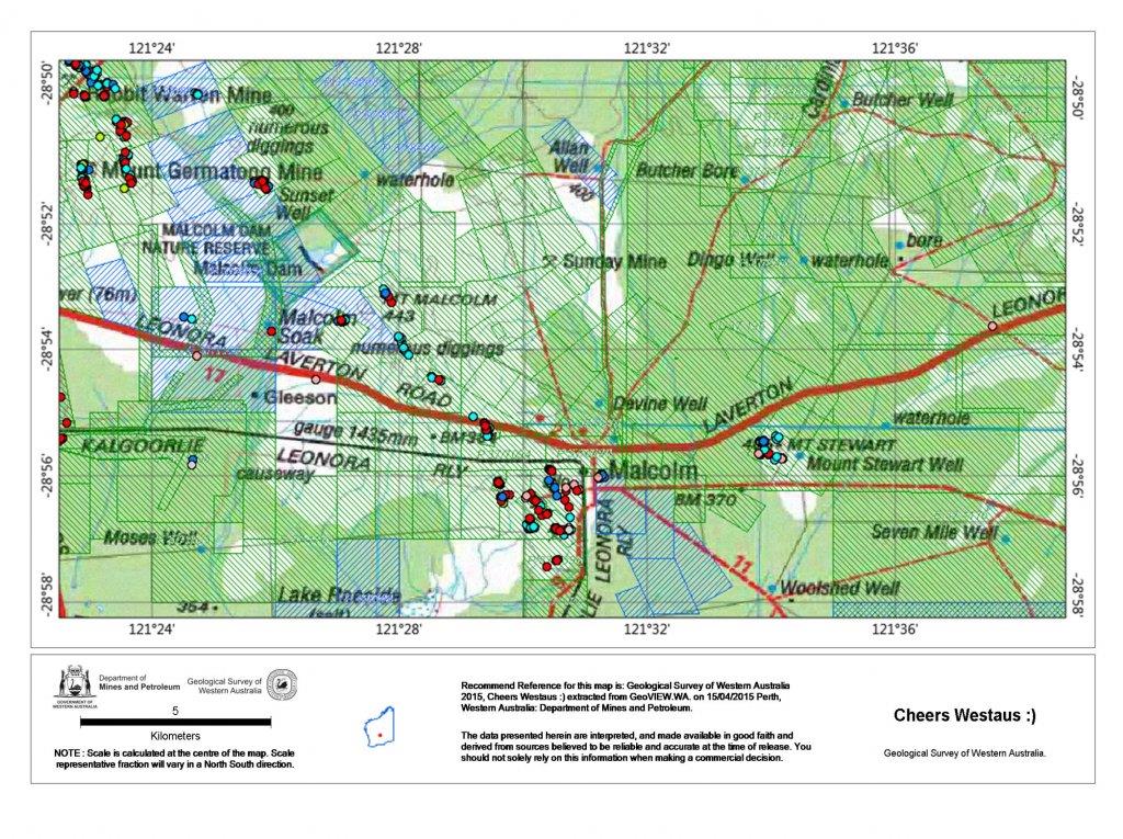
100K topo as above

1429113288_leonora_2015-04-15_tenements_100k.jpg


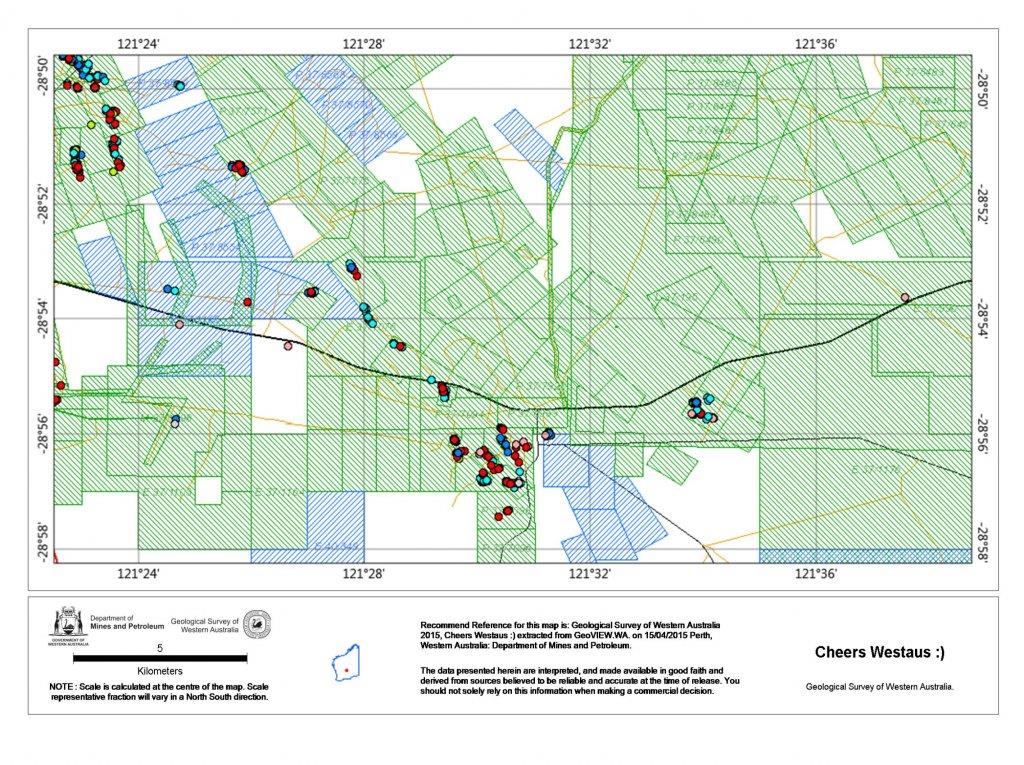
100K basic just the data needed

1429113326_leonora_2015-04-15_tenements_100k_basic.jpg


These can be made to suite and also done in pdf. You can get a higher resolution but for examples here and upload limits this gives you an idea. I can also put these into Google Earth if I wish along with then adding them into a Garmin device. It is now a Jpeg :) which is a format it inderstands. I can crop these using free software such as Gimp, all up to do a report like this takes me no more than 10 minutes to create. I can run it with many variables which I take in the field as back up for me. Generally 50k is about the best you get.

Have a play and see how you go, put your name on the course details if you wish just so I make sure your aware of details. This is only the start of what you can do :)

Edit - Detrack I think this is easier and quicker, I like what you have done and the resolution will be higher on yours no doubt, but these files do suffice in the field. Plus they are a lot smaller. I upload these to my dropbox and have them on my phone as a a backup as well. No right or wrong you still have the right data :)
 
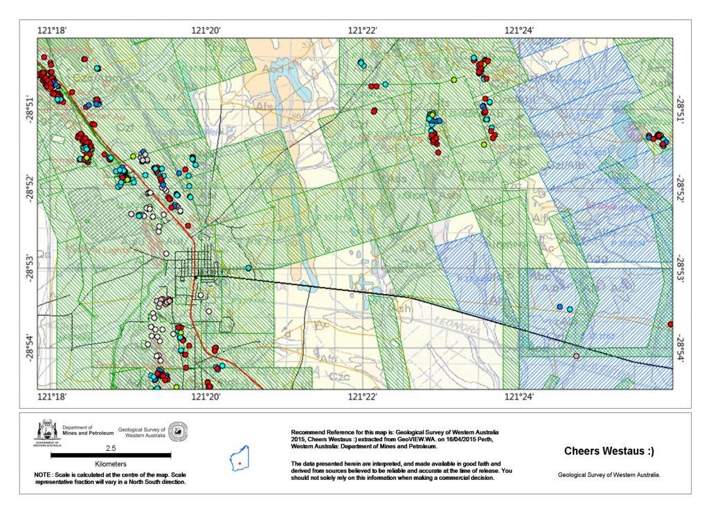
Here is a Geo version as well, I would play around with the layer more in Geo Map to get a better resolution, but for a basic outline you get the idea. You can then reference this against the topo etc... and start narrowing you search areas.

1429114152_leonora_2015-04-15_tenements_geo_50k.jpg
 
hucdj

I understand your frustration with GPS coordinates as we have all been there, I ask if you had Ozi-Explorer because if you want to transfer a location from a map to your GPS then ozi would be a good aid for you. maps with tenements that over power your detail maps don't make it easy to know were you are once your on the ground that you want to search but to be able to load a tenement onto a ozi map and then transfer that one EL to our GPS as a track file is the best way for you to know if you walk off the EL , you can save it to you GPS memory and then just bring it up at will. :D

I don't use Geoview for the reason you see on the above imagers I use more professional software to track myself around the goldfields like ArcGIS and MapInfo they will not drag down you system no matter what overlays you throw at it but this software is not for everyone if you have enough trouble with Tengraph. 8.(
 
G'day all, since the last time I used Tengraph, I have updated to Windows 10 with Microsoft Edge, today after downloading and installing Tengraph I find I no longer can use it as the Windows 10 browser no longer supports the required addition program "Silverlight", which is run in conjunction with Tengraph, I installed and tried to use Google Chrome to find it too does not support Silverlight, I then tried Firefox Mozilla which also does not support Silverlight. Further reading has me believe that the only way out is to get another computer plus a old copy of Windows 8 or earlier ... Can anyone currently using Tengraph tell me what your secret is to use it ?

Thank you for any advice or suggestion
Peter.
 
Shaker .. I've been using that path, it's the same hangup ... requires "Silverlight" to function, in a few minutes I am about to fire up one of my old shed stored computers and fingers crossed it doesn't go up in flash of smoke ... it may still have a functional old version of Windows on it ....
 
you can still download 'internet explorer' from microsoft I think, (that's what I did, but a while ago!) and also 'silverlight' and that will work on '10' otherwise if you have, or can find someone who has a '7' or '8' disc you should be able to just install I.E. from that
 
Cairnspom ... I've come up with the solution .. another computer, set up with a early version of Windows plus another laptop set up the same way so I can use it while travelling ..What a pain in the butt.
 
Help please IT people.
Can someone pm with a step by step instruction on how to transfer books, music etc from my iPad to my PC (Windows).
Thanks in anticipation.
Mackka
 
I find it odd that a govt department has such a primitive system. I made enquiries about using it on my Mac and they said 'tough luck'! I've heard people say that the staff there are very helpful, but that hasn't been my experience.
 
Anolphart .. I don't blame the WA mines department in any way .. they have a very good system that functions well and throughout their domain, the problem as I see it is the corporate giants who manipulate software usage (Microsoft Windows) to serve their interests, hence their no longer supporting software programs like SilverLight in their current operating system Win 10 .. Its a bit like all the new software programs that are released not being backward compatible, forcing everyone to keep upgrading.

BTW .. I'm one of the ones that say the staff at The Department of Mines and Petroleum WA are exceptionally friendly and helpful with the many contacts I have may with them.
 

Latest posts

Top