Regardless of the outcome, thanks for posting Rios and all especially S Wright. Ive learnt a lot. now to try and apply it to my own little dung heap 


blisters said:rios said:blisters said:Yep a fence will do it they can really make mag sing and the fence line is obvious in figure 3. above as well.
Any reason you aren't also looking at investigating the structure trending north east which aligns with the existing workings?
Jon
It is not within the jurisdiction of my claim, its another's claim 8.(
Somethings not right here, would it be fair to say that your lease is drawn too far to the north and east in post #3?
https://www.prospectingaustralia.com/forum/viewtopic.php?pid=314276#p314276
Jon
rios said:SWright said:G'Day Rios
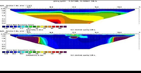
I have a lot of this sort of exploration in my time. There is really not enough information available in your reports to make a definite comment. However, generally I would not put much faith in IP. If I had dollar for every IP anomally I drilled in the early days of gold exploration I could start my own mine. Magnetics are really only good in that kind of geology for geological mapping as greenschist style gold deposits do not generally show up as an anomally as hydrotherml solutions generally destroy any mangnetic fractions. Gold reefs are therefore mostly magnetic lows.
My advice is to start from the broader exploration techniques to focus your targetting. Gold deposits respond very well to geochemistry in the first instance. I would go with say 50mX50m spaced BLEG - Bulk Leach Etractable Gold. This is a very sensitive technique able to penetrate thick sediment cover even in transported material and generally very cost effective. It can measure gold concentrations in ppb. You could also try a similar or closer spaced grid using fire assay carbon finish geochemistry that can resolve gold to ppt. With the latter I would use on identified BLEG anomalies. I would also look at what trace elements are associated with the reefs and undertake seperate but coincident sampling for that trace element be it arsenic, copper, antimony or whatever.
As for drilling versus shaft sinking. Diamond drilling is very expensive so I would first of all look to RAB drilling - rotary air blast. This could be concentrated on the main geological and geochemistry targets. Its quck and very competitive in price. Diamond drilling is only effective in areas where a surface resource has been defined and you want to go deeper. Most Australian mines only use diamond drilling for deep resources but rather they would use RAB followed by open hole and reverse circulation percussion drilling to define a resource in the first 100-150m.
Exploration shaft sinking should be the last thing you try.
Araluen
Below is the response from the report writer
"There are a couple of issues that are not being taken into consideration
1. We knew the reef was present so sampling the soil was not necessary
2. Magnetic signatures are not killed by hydrothermal activity as the area result of actual minerals which are not strange in hydrothermal conditions - what i think he wanted to apply that thinking to is resistivity data and if so yes i agree as hydrothermal units tend to impede current flow.
3. IP yes can be tricky but so is geochemistry im currently working on a project where over 30k soil samples where analysed to find the actual pathfinder minerals but we found one that had 60% correlation and guess what, we had to do IP for us to plan a drilling program.
There is not one method to take you to production but a combination of them
Combination of which is controlled by budgets.
At the end combining available data with relevant experience is the solution"
Keen Ken said:It's all good, and I wish you well.
It's just when someone starts mentioning Money from overseas alarm bells start ringing:-/.
Self funding is the way to go if you can keep the bills paid.
I did it, took about 5 years to become established and only became really successful in the last 3 years.
No partners, no one to pay back, no lost friends.
Just native title, EPA, DNR&M and the usual other hassles to deal with.
Do check out that percussion drilling rig, it will save you heaps.
bundyjd said:rios said:SWright said:G'Day Rios
I have a lot of this sort of exploration in my time. There is really not enough information available in your reports to make a definite comment. However, generally I would not put much faith in IP. If I had dollar for every IP anomally I drilled in the early days of gold exploration I could start my own mine. Magnetics are really only good in that kind of geology for geological mapping as greenschist style gold deposits do not generally show up as an anomally as hydrotherml solutions generally destroy any mangnetic fractions. Gold reefs are therefore mostly magnetic lows.
My advice is to start from the broader exploration techniques to focus your targetting. Gold deposits respond very well to geochemistry in the first instance. I would go with say 50mX50m spaced BLEG - Bulk Leach Etractable Gold. This is a very sensitive technique able to penetrate thick sediment cover even in transported material and generally very cost effective. It can measure gold concentrations in ppb. You could also try a similar or closer spaced grid using fire assay carbon finish geochemistry that can resolve gold to ppt. With the latter I would use on identified BLEG anomalies. I would also look at what trace elements are associated with the reefs and undertake seperate but coincident sampling for that trace element be it arsenic, copper, antimony or whatever.
As for drilling versus shaft sinking. Diamond drilling is very expensive so I would first of all look to RAB drilling - rotary air blast. This could be concentrated on the main geological and geochemistry targets. Its quck and very competitive in price. Diamond drilling is only effective in areas where a surface resource has been defined and you want to go deeper. Most Australian mines only use diamond drilling for deep resources but rather they would use RAB followed by open hole and reverse circulation percussion drilling to define a resource in the first 100-150m.
Exploration shaft sinking should be the last thing you try.
Araluen
Below is the response from the report writer
"There are a couple of issues that are not being taken into consideration
1. We knew the reef was present so sampling the soil was not necessary
2. Magnetic signatures are not killed by hydrothermal activity as the area result of actual minerals which are not strange in hydrothermal conditions - what i think he wanted to apply that thinking to is resistivity data and if so yes i agree as hydrothermal units tend to impede current flow.
3. IP yes can be tricky but so is geochemistry im currently working on a project where over 30k soil samples where analysed to find the actual pathfinder minerals but we found one that had 60% correlation and guess what, we had to do IP for us to plan a drilling program.
There is not one method to take you to production but a combination of them
Combination of which is controlled by budgets.
At the end combining available data with relevant experience is the solution"
Hi Rios,
I don't know anything about your geologist's background or experience, but I do know SWright's which is why I asked him to pop in here and provide an answer.
As well as being a handy man to know, he is a busy man at the moment - so if you are looking for a response to the above it might be a while...
I hope what was already provided has been helpful
Regards,
John
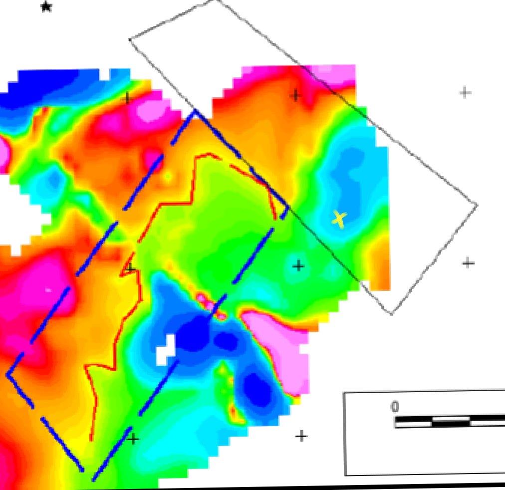
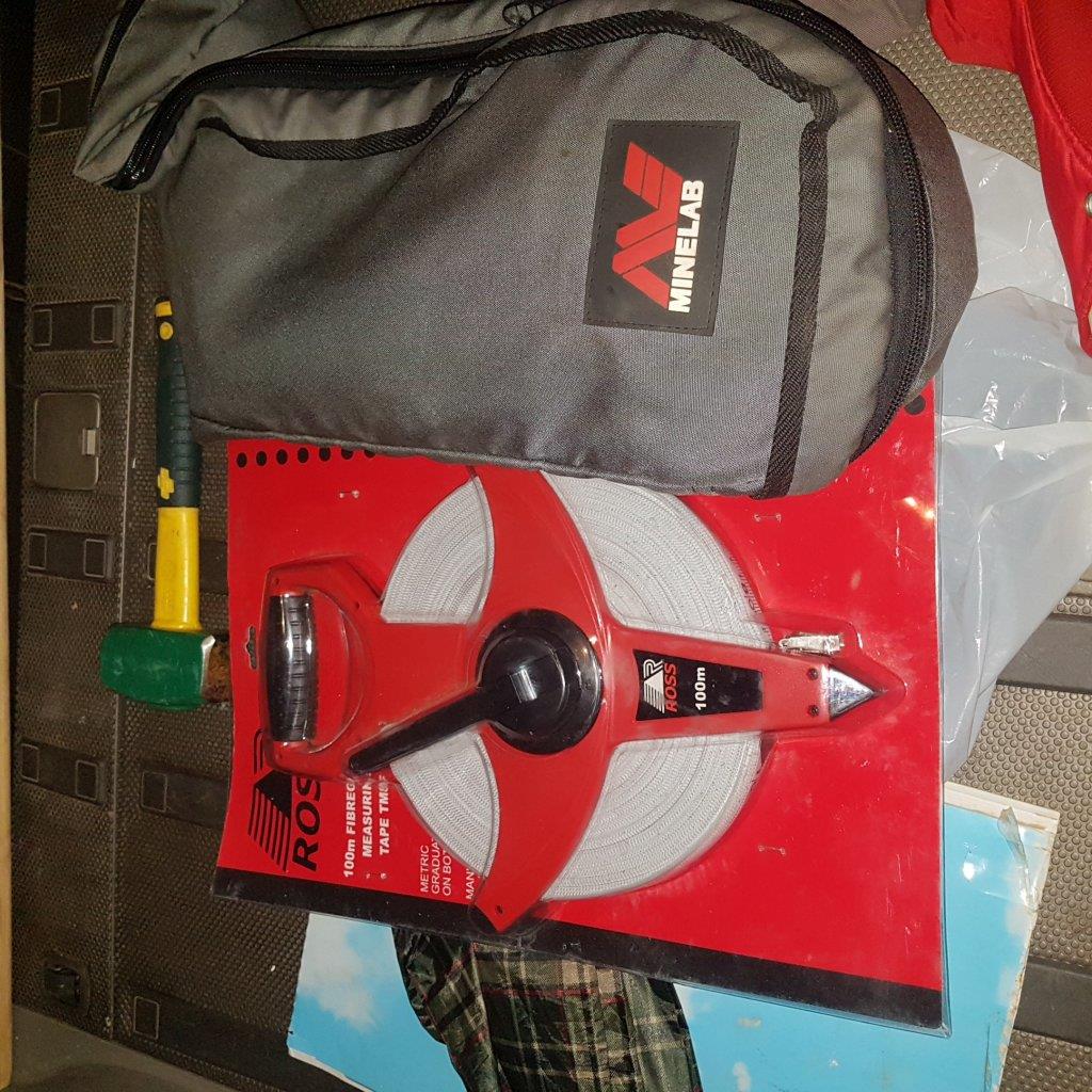
blisters said:You shouldn't have to be concerned about hitting a target from the perspective of the positioning on the ground of a geophysical survey anomaly. While GPS is good I wouldn't rely on it rather on a lease your size I would have three pegged lines at 50-100m intervals running the NE length. All surveys should work from these pegs which are measured from a lease corner so follow up can be measured out easily with a 100m tape. Keep in mind though that with a depth to target of 50m it's not going to be accurate to metres but no point adding to inaccuracy on the surface. The IP is pretty close to the edge of your lease as well and half of RS1 is outside your lease. No doubt you'd have holes to position yourself with the IP but what about the positioning the mag, how accurate is the mag to your lease and in turn the position of the IP to the mag?
Jon
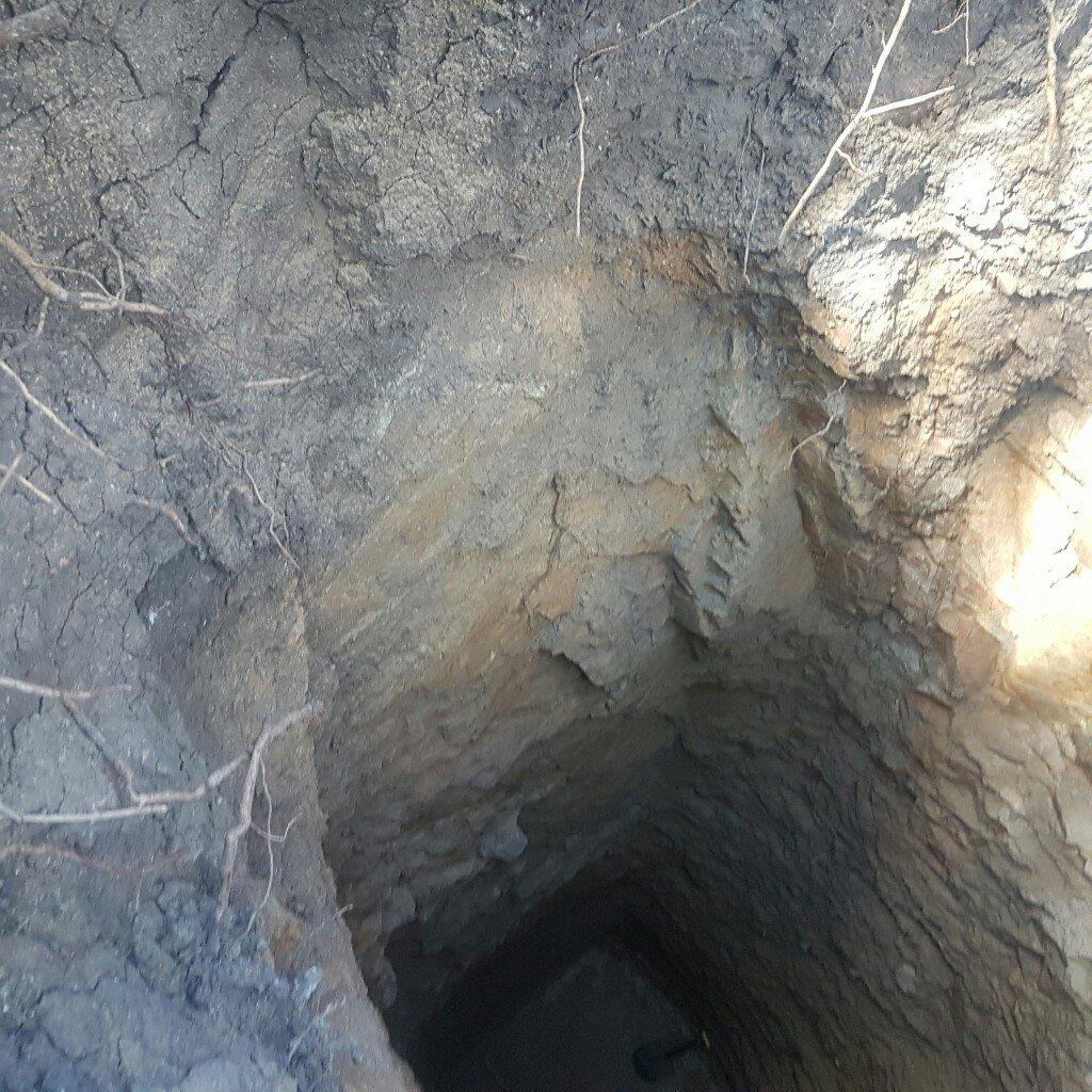
rios said:Will take further samples maybe after digging a trench using manual labour, not a trench maybe, i could dig a few metre or so shafts and re-test. Ultimately i believe there is a reef structure thats leading to the eluvium above.
grubstake said:rios said:Will take further samples maybe after digging a trench using manual labour, not a trench maybe, i could dig a few metre or so shafts and re-test. Ultimately i believe there is a reef structure thats leading to the eluvium above.
If you're going to be a miner, you need to learn the lingo, mate! In mining, "trench" = costean (https://www.merriam-webster.com/dictionary/costean).
And good luck to you! :Y:
Enter your email address to join: