My Tassie 2 day Bazooka experiment

Prospecting Australia

Help Support Prospecting Australia:

This site may earn a commission from merchant affiliate links, including eBay, Amazon, and others.
Joined
Mar 16, 2014
Messages
60
Reaction score
7
Took the kids down to the Styx River, just past Gold Creek, yesterday for a fun family day/panning expedition. Took the Bazooka out with me, spent most of the time trying to get it set up right. Fell over in the freezing water and had my waders fill up :/

Was a fun day though. Didn't find a speck of gold. Quite a bit of quartz though that got us excited. The bush around the river is extremely dense, hard to get through. Found it easier to walk through the river and leave my kids and wife to the leeches.

Decided last night that I would go back out (only an hour drive from home) by myself without worrying about the kids drowning or the wife having hysterics over the wildlife. Did a stop at Gold Creek on the way through. Got out of the car and it started hailing. brrrr.... Found my way down into the creek and could barely turn around, let alone shovel, it was so covered in fallen trees and overgrowth. Did a few sample pans before saying 'screw this' and trying the Styx again, this time trying a couple of points I had located on the map beforehand.

Spent a lot of time bushwalking/wading with the Bazooka. The best way I could describe it is like trying to bushwalk with a hard guitar case. Gets a bit cumbersome, not ideal when I'm either trying to jump over mossy fallen trees or walk along a strong stream because the banks are too overgrown.

Despite the chill, I was pretty warm in my (recently dried) waders, plus all that shovelling to keep the blood pumping. Think I'm getting better at setting up the Bazooka, but it still takes longer than I would hope. Especially when I'm just trying to sample areas. Gave up on it by the end of the day for sampling and just went around taking pan samples.

Called it a day when I noticed the river was getting stronger, plus tiredness...

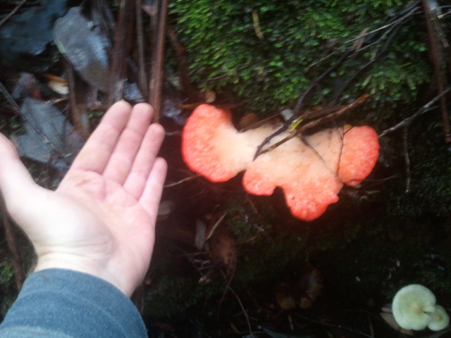
Didn't find a speck of gold for the day. Found something that I think might be a small piece of os. Doubt I'll go back to The Styx again, which is a shame as it's relatively close to where I live and is amazing to look at, but it's just too hard to move around down there without a boat. Still, had fun and I'm pretty sure I've discovered a new breed of mushroom.

s3YDj35.jpg
 
Hi Hurg,

There are very small flecks of osmiridium in the Styx around Gold Creek. I've never found gold there either. There is gold somewhere in the Maydena area, as Maydena locals were selling small quantities of gold to the mines department in the 40s. They may have come from other areas in the upper Weld or Styx, now in the national park.

There are old reports of gold in the Esperance, Lune and D'Entrecasteaux rivers, but no detail of where or how much. I've been meaning to get myself down there to have a go for some time, but I never seem to find enough time!
 
Hey mfdes,

I really wanted to check out Fourteen Mile Creek but the Mueller Road gate was locked. Maybe next time.

I used to teach at Maydena Primary School a few years back, can't believe I did that drive every day. Must have involved a lot of zoning out at the wheel.

I would love to own a little cabin in the woods over that way. Would be even better if there was gold nearby.
 
I never got a color at gold creek either, had detailed maps of the previous work and still nothing 8.(
I did manage a few colors in the D'Entrecasteaux.

DD
 
Hi Hurg,

I've gone into Fourteen Mile Creek from the Maynes Hill Rd end. No joy, the creek is sluggish and the wash looks miles deep. We're really a bit starved for gold down here. I think daytrips to Mangana/Mathinna are more viable.
 
Have you guys ever had a go at detecting down here? I know that Tassie's not meant to have large nuggets, but I also know that there have been some found over the years.

Walking along the Styx the other day, I sort of could see where I think the river used to run (was a flat section of ground and on inspecting the roots of a fallen tree I found some smoothed rocks). Would have liked to try a detector around some of the trees just in case.

I went to Mountain Creek today and the guy stocks a couple of different Garrett detectors, including the AT GOLD/PRO and ATX. My missus is harping on about how we should buy one but I'm not convinced that it would be a good investment.

It did seem like if there were nuggets there, they'd be buried under a lot of topsoil.

Cheers
 
Hi Hurg,

There are no historical finds of nuggetty gold in the south of the State. Up northeast and on the west coast, yes. A lot of our ground is very scrubby and hard to detect in, some areas are better than others.

I use my Garrett AT Gold most for coin shooting, though I originally bought it for searching for nuggets up NE.
 
Hurg said:
Have you guys ever had a go at detecting down here? I know that Tassie's not meant to have large nuggets, but I also know that there have been some found over the years.

Walking along the Styx the other day, I sort of could see where I think the river used to run (was a flat section of ground and on inspecting the roots of a fallen tree I found some smoothed rocks). Would have liked to try a detector around some of the trees just in case.

I went to Mountain Creek today and the guy stocks a couple of different Garrett detectors, including the AT GOLD/PRO and ATX. My missus is harping on about how we should buy one but I'm not convinced that it would be a good investment.

It did seem like if there were nuggets there, they'd be buried under a lot of topsoil.

Cheers

We detected quite a few nuggets over two days at Back Creek, while we were waiting for the spirit of Tassie. Did a few days detecting around Mathinna for none.
Never found an area worth detecting in the south. Your best bet would be to get access to the private land around Cygnet, or head north.
 
Well, my tenants just gypped me of two weeks rent, so I'll be finding new ones and doubt I'll have the money for a while.

My wife got the itch to go for a bit more of a hunt as a break from her uni stuff so we chucked the kids in the car today and tried out a couple other places in the Maydena region . Started by taking Coopers Track near Mt Mueller (on the non-NP side of the road) and hitting the stream (Upper Florentine?) there. Was a almost a perfect spot, great access but hidden, good flow of water but shallow so I got the Bazooka up and running in minutes. Only reason it wasn't perfect was that we didn't get a speck of gold after spending a couple of hours digging around that spot. Moved on to the area sort of near Tim Shea, found the creeks but they were empty. Moved down to Kallista creek, found some small bits of greenstone that looked like they may have been crushed, tried a few different spots but no luck. Went down and tried the Humboldt (at least I think that was it, looked more like the Tyeena though) and again not a speck.

Pretty much done with Maydena. My wife wants to try Adamsfield but I'm more interested in heading to Mathinna or Corinna.
 
There wasn't a lot of water in Mathinna last time I was there, but it was summer.

Have you tried reading the stuff on the MRT library? They have hundreds of old books, reports, bulletins, etc on mining around Tasmania. It's all free access. The best way to use it is to use Google to search the site, like this: if you wanted to search for alluvial gold references you'd use "site:mrt.tas.gov.au alluvial gold"

Hope this helps, all you need to know is pretty much there, I doubt there's much of the state left unprospected.
 
The Google Earth points plus the Trove database should put you on a workable field. Have to make sure it is alluvial as well.

Been looking at some new spots at the moment to run a sluice.

Didn't see much at Maydena in the way of gold on the Google Earth reference points layer.
 
mfdes, yeah been reading the stuff on MRT. The only problem is, there's so much to learn that it's a bit overwhelming and I find myself with half a dozen tabs open at a time. Didn't know about that Google trick, sounds good. Cheers.

Redmanti, I've been using the Google Earth points, but I haven't had much luck with them. It would be great to find more info on each site and how accurate they are. Haven't looked at the Trove database yet. Way too much reading :/
 
I've been using the Google Earth but verifying them with old newspaper reports on Trove. Otherwise, there may be no gold in the river or the gold isn't alluvial.
 
Hi Hurg

A couple of us will try the NE and also Nichols Rivulet & Oyster Cover which is closer to us. Let me know if you want to catch up sometime.

I read your post about the Styx Valley and Gold Creek, I went there by myself earlier this year. Trying to get near the creek up the hill was hard and I fell though some rotten tree trunk and was stuck down in up to my chest. Lucky I wasn't hurt and was able to get myself out or the devils would have eaten me by now.

I wanted to head along Mayne's Road that runs parallel to the Gordon Road out to Mt Mueller. There was a boom gate that was locked so I took the next turn in to the right and went in a fair bit but there were tracks everywhere. Trucks had been in there because the tracks had new gravel added in places. I found most of the creeks dry, stopping near corners, getting out listening for running water.

The Styx had plenty in it but I wasn't panning in there. Pity that the way out is blocked just past the Tall Tree walk it would be lot quicker heading back possibly through the coup on the Karanja straight near Westerway.

Also did a trip down to Adamsfield, almost all the creeks were dry, found nothing in the creeks (not many flowing last February). Only got rich on the scenery it is magnificent looking out over the lakes...maybe next time now I know what it's like out there and after there's been a bit of rain to make it worthwhile going all that way.

Don't give up trying...cos the only nuggets you'll find on the couch will be bum nuggets.
 
Hello all im a beginner at this and was wondering if anybody has paned the coal river at richmond ?...we have aggots in the area but was wondering about the coal river cheers??
 
Another resource not mentioned here is the Australianminesatlas. Click on interactive mapping/ create a map. Zoom to your area, then put in roads, rivers, population centres and Gold occurances in the mineral occurrances section. I'm not tech savvy, so I print this then compare with google satellite images to get the exact spots.
 
Yeah..... I got it to open but cannot see any links to gold data, and have no idea how you got those gold marker pins on Google (have never used Earth as far as I know).

All way, way too hard for me. I'm a scrubber. When I go to Adelaide, I find my way by judging distance and direction to MT. Lofty, and watching for the street signs. Same principle applies for gold. Zoom in, look for the quartz reefs and exposed rocks and off-colour vegetation.
I recently got a GPS, but those things can lull you into a false sense of security-better off to be spatially aware at all times. Observation comes naturally for me, after decades of station life I have to slap myself to stop checking the fences for holes and looking for animal trails when driving down the road. The GPS shows me where I've been, not where to go.
Tassie might not have as much gold, but the people are solid gold.
 
You can click on "Layers" on the top right of the MRT map, and add the "Mineral Occurrences" layer. This will include all minerals, not just gold. Green icons are alluvial deposits, and these are main ones to look for: they'll be either gold or tin 99% of the time.

With the Google Earth overlay, you need to have the Google Earth software installed in your computer before you can open it. It's the exact same information as you get from the Mineral Occurrences overlay in MRT map, but without minerals other than gold.
 
rustypan said:
Hello all im a beginner at this and was wondering if anybody has paned the coal river at richmond ?...we have aggots in the area but was wondering about the coal river cheers??

Chalcedony down and around pit water at the base of the old jetty, plus I know of a beautiful deposit of petrified wood in Richmond too. Best get a detector mate lots of old relics. I have lived here for 28 years, great place. The bream are running now, bottom weir.
 

Latest posts

Top