Deciphering Doug Stone maps and trying to correlate that with GeoVIC

Prospecting Australia

Help Support Prospecting Australia:

This site may earn a commission from merchant affiliate links, including eBay, Amazon, and others.
Joined
Jun 18, 2014
Messages
46
Reaction score
7
Hi Folks,

Thanks for all of the support and help you've been over the past few months! it's appreciated and I'm learning lots. So I'd like some assistance in deciphering, for want of a better term, Doug Stone maps or, in general, any detecting map & GeoVIC data. I'll reference the Beaufort map that I have as that's right in front of me.

I've learnt a few important things:

1) Deep Lead mining is not the same as Quartz Reef Mining - I was, previously, of the view that if there was a shaft that the old timers were getting reef gold but that thought has been corrected. Deep lead mining refers to accessing alluvial gold in old stream beds etc that are meters under the surface.
2) Alluvial Gold doesn't just refer to the stuff sitting close to the surface - it can also be associated with old rivers etc meters underground

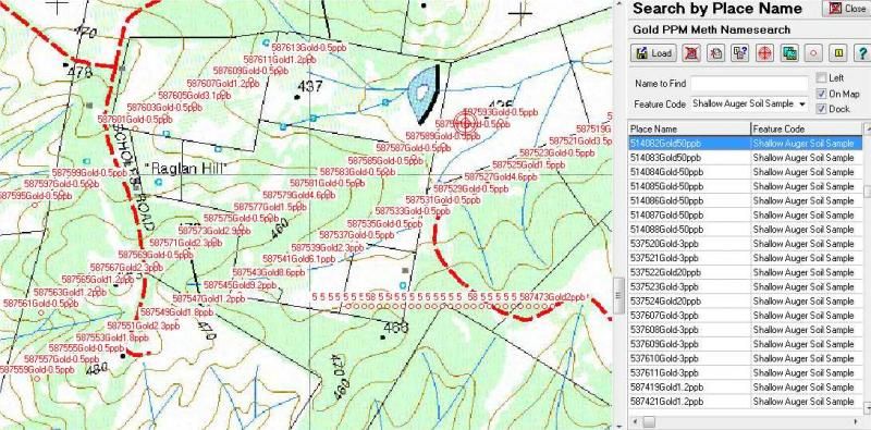
I've been comparing Doug Stone maps with GeoVIC data and trying to get some correlation between the two... I've noticed, and I'm particularly looking around Beaufort/Chute, that what the Doug Stone map refers to as Quartz Reef (i.e. Waterloo Lead) the GeoVIC data refers to as Deep Lead Lines. I also noticed that GeoVIC seems to include more of these Deep Lead lines than is referenced on the Doug Stone maps i.e. Doug Stone references the Waterloo Lead with several offshoots including a short Sulky Lead. GeoVIC references a much longer and branchier Sulky Lead around Chute and more detail along the Waterloo Lead. Why is that? and here, where GeoVIC reference Deep Lead Lines, are they referring to Quartz Reefs?

I've also noticed that the Quartz Reefs (Doug Stone)/Deep Lead Lines (GeoVIC) seem to lay in gullys and the Gold Diggings (Doug Stone)/Shallow Workings (GeoVIC) seem to extend uphill. I thought the gold was shedded from the reefs and would have then run downhill - or is it possible that the gullys that the gold is in now was once lower than the area through which the Quartz Reefs/Deep Leads run? The below picture kind of shows what I mean. Can anyone explain what I'm seeing?

1417002009_chute.jpg


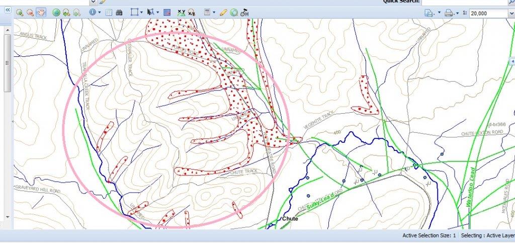
In the pink circled area, by my very novice thought, the reef should, theoretically, be on the ridge top for the gold to run down the gullies in the above picture headig down toward the deep lead line.

Also, when the Doug Stone Maps/GeoVIC maps refer to Gold Diggings/Shallow Workings does this mean surface gold or can it also reference deep lead mining? In the majority of areas where Gold Diggings are referenced there aren't any shafts shown so I'm assuming that it's nearer the surface. Also, if there is a shaft pinpointed in a gold diggings area would that typically mean that the gold is deeper than the realms of a detector?

Also, how is it that there can be pockets of gold diggings so far away from the Doug Stone referenced quartz reefs or is it possible that not all of the quartz reefs/sources are known? The Beaufort map pretty much suggests that any water course in that area has gold... How does Doug Stone, or GeoVIC for that matter, determine the extent of the gold diggings? is it simply a combination of historical data and geological information?

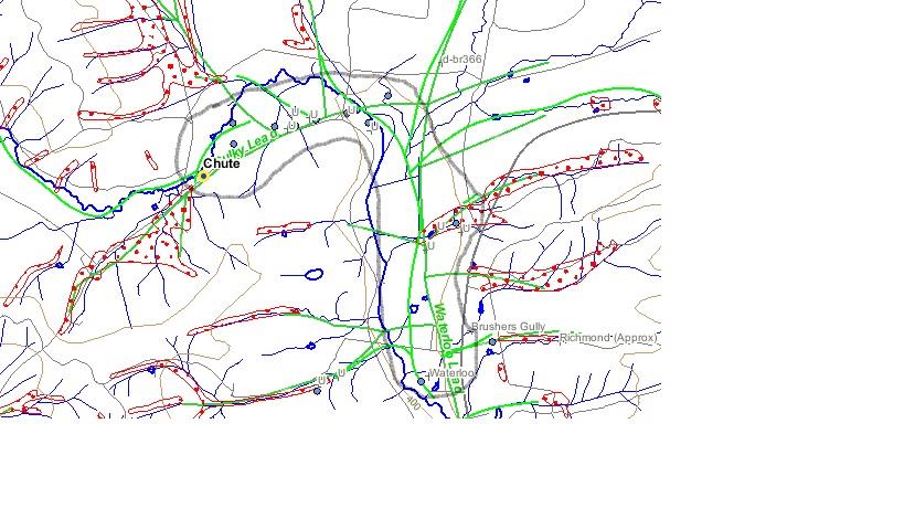
Also, I noticed on the GeoVIC map around Chute that there's two slighty different coloured deep lead lines - what does that mean? they both seem to follow quite closely to each other but are slightly different shades of green. You can see them both in the above image.

Apologies for all of the dumb questions but I thank you for your patience in helping...
 
Mate...you ask many and varied questions and unfortunately I cannot answer all of them.

I hear what your saying and it may come down to different terminaology being used by Doug stone and Geovic.

From my understanding on the Stone maps all the red shaded areas are shallow gold diggings/leads. These can be up to 60ft deep but also maybe just below the surface in detectable range. The Red lines/ deep leads are generally much deeper than that and possibly speculative. These are shown in green on Geovic.

If the maps indicated every shaft in an area an army of people would have to walk every inch of land and plot each shatf they come across which is never going to happen. Many smaller, shallow shafts are long forgotten and filled in. Maybe only the bigger deeper shafts are noted for reference.

As for the pic, you have a ridge line and the gullies off the sides all have gold diggings. This does not indicate that there is/was a reef on top of the hill shedding gold into them gullies. What may have occured millions of years ago was that there was an ancient river bed in the location that had auriferous gravels. Over the ages land masses rise and fall and erode. Where a river bed once was is not the top of a hill and the alluvial gravels have now eroded down into the gullies. Sure, there will still be gold on top but the higher concentration of gold will be in the gullies, thats why the old timers dug there. No point moving the top of the hill for little reward.

If you look on google maps and follow where the leads are on your doug stone map you can see what looks like 'Acne' in the fields where the shallow leads/diggings are. This indicates the shafts that the old timers dug to get to the old river beds. These areas are good for a detect around the mullock heaps and yes there is still virgin ground there but it may be meters undergorund still.

Hope that helps,

Cheers
 
:lol: Welcome to the world of Doug Stone maps. First, I gotta say I have used them and still own some and when I was a newie they at least sent me in the right direction, I say that loosely. But never rely on them for true accuracy, just a rough guide to get you somewhere, but sometimes the road may not actually be where he shows it and sometimes neither are the diggings. I once went to a place a number of years ago that was shown on one of his maps. It showed a large area of digs, to cut it short there was nothing there at all and never had been. And no they had not been dozed in or the land reclaimed, they never existed! Had they actually existed they would have covered a fair acreage. I now tend to think of them as glorified mud maps. Worthy of existence but at the lower end of accuracy.
 
MJB said:
. Many smaller, shallow shafts are long forgotten and filled in. Maybe only the bigger deeper shafts are noted for reference.

As for the pic, you have a ridge line and the gullies off the sides all have gold diggings. This does not indicate that there is/was a reef on top of the hill shedding gold into them gullies. What may have occured millions of years ago was that there was an ancient river bed in the location that had auriferous gravels. Over the ages land masses rise and fall and erode. Where a river bed once was is not the top of a hill and the alluvial gravels have now eroded down into the gullies. Sure, there will still be gold on top but the higher concentration of gold will be in the gullies, thats why the old timers dug there. No point moving the top of the hill for little reward.

If you look on google maps and follow where the leads are on your doug stone map you can see what looks like 'Acne' in the fields where the shallow leads/diggings are. This indicates the shafts that the old timers dug to get to the old river beds. These areas are good for a detect around the mullock heaps and yes there is still virgin ground there but it may be meters undergorund still.

Hope that helps,

Cheers

MJB, thanks so much for your feedback - it makes perfect sense! So, one could almost assume, that the gold in those gullies (referenced in the previous picture) is shallower than in the below image.

So is there any way of determining, from geological information/maps, whether the gold is likely to be deep or shallow? Or is it just a matter of connecting the dots in a sense? I have been told that if there is a shaft at the top of a hill you should work down from it in to the gully below - I'm guessing there is the potential that gold brought out of the shaft may have been dropped/missed but also that the gold bearing gravels might have come closer to the surface further down the hill. I'm sumising from the GeoVIC data (which is kind of backed up in Doug Stone) that the deeper shafts (that are still apparent) are in a concentrated area which suggests the gold is deeper down - so, in those areas, you'd be best to focus around the mullock heaps etc and run under the assumption that they didn't get everything? Am I drawing the right conclusions?
1417053839_shafts.jpg
 
Jon said:
:lol: Welcome to the world of Doug Stone maps. First, I gotta say I have used them and still own some and when I was a newie they at least sent me in the right direction, I say that loosely. But never rely on them for true accuracy, just a rough guide to get you somewhere, but sometimes the road may not actually be where he shows it and sometimes neither are the diggings. I once went to a place a number of years ago that was shown on one of his maps. It showed a large area of digs, to cut it short there was nothing there at all and never had been. And no they had not been dozed in or the land reclaimed, they never existed! Had they actually existed they would have covered a fair acreage. I now tend to think of them as glorified mud maps. Worthy of existence but at the lower end of accuracy.

Hey Jon, thanks for your reply mate! I guess that's why it's important to compare multiple information sources? So would one say that GeoVIC is more accurate? I gues that's where the saying "Gold is where you find it" came from :)
 
I agree with the above....

I was recently at the Laanacoorie Gold Bash, I met and spent a fair time with Doug Stone, primarily looking at his maps and what I have done with them.

I have scanned his entire Victorian map set, then calibrated them into Oziexplorer and use them on a GPS dash mounted Android tablet.

From this and my discussion with Doug, I'll make the following points;

  • His maps scanned and calibrated reasonably accurately (paper does shrink and expand over time, so it's not perfect). The slight errors are liveable for me.[/*]
  • His maps are not full Topographical and are not intended to be. (They do not show all tracks and Topo detail)[/*]
  • The Victorian maps were actually produced about 30 years ago and therefore may not have newer detail on them.[/*]
  • He is investigating the possibility of releasing his maps as an App, but obviously has to ensure that Copyright protection is maintained.[/*]

And, yes I am perfectly in my right to have digitised his maps and he agrees, I bought the book, how I use it is my business. Providing I do not give away or on sell his intellectual property. So, please do not ask.

I actually gave him a copy of all the map images and .MAP files to assist his App investigations.

To clarify accuracy - The position of main roads and most tracks, I know to be reasonably accurate from a calibration viewpoint. I make no comment on the accuracy and position of the diggings etc he depicts, other than to say, I have only been detecting for 2 years and only 6 or so weeks each year and so far most of the diggings I have seen are on the maps.

I have no affiliation other than stated with Doug Stone.
 
Most of the times the reason a shaft was at toward the top of the hill was because they Loamed up the gullies which lead them to the place the gold was coming from.

Imagine a buried riveer bed on the hill feeding gold down the slope and into the gully over a very long time.

Sometimes on shallow diggings, once they got down to the pay dirt they did not realize straight away and as a result there might be some unwashed pay dirt sitting on top of the Mullock heaps. There might be nothing there but these are always a good place to start looking.

As for the depth of bedrock....good question. Take an auger and drive it down. If its further than what you are prepared to dig forget about it. The old timers had to do it the hard way. Spend 3 months sinking a shaft only to find its a duffer when they hit the bottom :mad:
 
Also met Doug at the Laanecoorie Bash recently and personally witnessed the time condor22 spent with him.

Both Doug and Condor are great blokes, and Doug works tirelessly on the profession he loves in order to not only make a living from it, but also helping to bring us prospectors a guide that helps to put us into the right areas and stack some odds in our favour.

No map offers pinpoint accuracy as this would be near on impossible to achieve. Also don't see that its absolutely necessary.

We would all love a big red arrow pointing to a spot that says, "You will find gold here", but in the real world, this is simply a fanciful dream.

I personally love his maps and have also never had an issue with them in locating places I am after. Im not really bothered by the fact that if a certain track I come across is not listed. I love adventure as much as I do prospecting and once I get to an area, the rest is up to me!
You don't need superior map accuracy to find gold, just a little bit of forward thinking, reading the ground and general area for yourself, and making your own interpretations based on the knowledge you are given and posses already.

Condor was kind enough to show me his work with Doug's map digitization and I must say, it is superb stuff and obviously works very well for him.

I was back at the park a week or so ago and old Ted who was in the van behind you Condor is still there. He has been detecting tirelessly everyday since the bash and as a result, has been able to come across a few lovely patches of his own with quite a few ounces in his kick as a result.
His Doug Stone maps spread across the front passenger seat of his Pajero.

Look forward to catching up with you all again next year.

Doug and I at Laanecoorie.
10i5kav.jpg


Maybe the pics of himself on his books are out of date, but he tells me it helps the ladies to buy more....bahaha!

Regards
 
I too, have met Doug on a few occasions over the years and also have his Gold Atlas, to which I refer to quite a bit.
I also admire his professionalism and dedication.
His gold tours in the 80's were legendary.
I also think his maps are at the lower end of accuracy.
Not a criticism, just an observation and opinion.
 
As time moves so does the ground which changes all areas of the bush

The wind and rain carry soils, expose certain geological aspects and cover others with extra layers!

On occasions Prospectors move in with machinery, shift old leads, carve new tracks and cover old ones.

Nothing stays the same Redfin.

I know what your saying, but I don't see how its super relevant......they are certainly accurate enough to find your way around a general area.
 
:lol: I think it would have taken an absolutely cataclysmic event to have covered the area I went to. Couple of volcano's, earthquake, and a tsunami.
Not knocking the guy but like Redifn said, just an observation after over 2 decades of having used them. Compared to a Tully map, well, no comparison really.
Helps to use a few, Tully, Dougs, geo maps even the odd Vic roads map. It is nice though to know beforehand that a certain pictured set of diggings actually exist before wasting your time to find out they never did. Iv met him too quite a number of times, which means.......squat.
 
Thanks for the Vote Metamorphic and great to see old Ted doing well, I learned a lot from him and yes, hope to see you next year.
 
Jon said:
It is nice though to know beforehand that a certain pictured set of diggings actually exist before wasting your time to find out they never did. Iv met him too quite a number of times, which means.......squat.

:lol: Why didn't you cross reference with your vic roads maps before you left. Im sure they would have led you to the gold rather than waste a day...Lmao
 
Hi Oz_Gold

I hope you are sleeping ok ? you sure are doing you very best to understand Geographic Information but try not to look to hard into it all just use the Geological information that you see on maps as a reference in your search of a area to try, there is many other form of data that will show gold bearing ground and they will not be shown on a map, for a sample Geochemistry sampling is one of the very first steps any geologist would take in search of a new area as old timers did with panning and loaming.

Take the area 1K west of your Chute map as you can see by this map I have posted they had done sampling with a hand Auger and this is a 100mm long by 50mm Auger and they have had some very good reading so would you not say it would be worth a look, I would think so, there is no other geofeature there no Deep leads, Shallow Leads, Reefs, but to look at those samples would think it would be Shallow ground.

Image2_zps025c2c0f.jpg


Just keep in mind that any of the leads that run up a face will be a lot more shallow then the ones down in the gullies on the flats so working up high would be you best aim to search and as other have said not all hill tops have reefs on top or over them as these hills could easy be of a Tertiary nature (Tlw) auriferous gravels.

GeoVIC are more accurate then Doug or Tully maps, keep in mind all maps are only for reference in our game as it no good to be standing on X marks the spot as if it was there then there has to be more all around :eek:

Many of the maps you look at show Shallow ground as the dotted areas on your post but not all of them will have digging on then and that doesn't mean that there is no gold there, search the slopes and if you do see any of those dotted areas running up a face of a hill and no gully to be seen then make sure you Detect it well :cool:

Looks to me that Beaufort is the place you are wanting to spend a lot of time, and why not it has it all, just read all that you can get your hands on and here is a couple to start with

Bulletins number 28 ,32, 62 as well look at Deep Leads Vic Memoirs-7

cheers
David
 
That's great stuff Detrack....you just taught me heaps.

Where do I look for the bulletins? just had a quick try in google and it came up with zilch
 
i have A doug Stone book very old one and I came to the conclusion that his printers might have got it wrong there are spots where he shows surface workings and it was deep leads about 200ft near Cape Clear so just do some research and if you get to a spot and the Mullock heaps are 50 feet high it was deep leads but there are lots a of reefs across victoria so dont be surprised to see surface workings and some leads as well as it has had 4 billion years to get messed up , I would recommend reading as many sources as possible lots of great free stuff online, lots of Gold forums out there

cheers Ron
 

Latest posts

Top