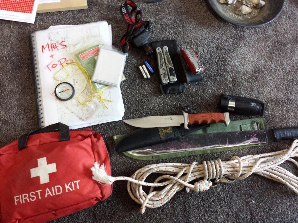
What Method Do You Use So You Don't Get Lost in the Bush?

Prospecting Australia

Help Support Prospecting Australia:

This site may earn a commission from merchant affiliate links, including eBay, Amazon, and others.
Wolfau said:
I use a GPS, correct compass setup with the arrow pointing to my car and 400 metres of quality rope

which follows me when heading out. I carry a camel back full of water, matches and some tin tuna.

You can't just rely on a GPS :D

Hi wolf, do you carry 400m of rope? How thick is it?

I have walked/canyoned some remote places in the Wollemi NP and recently Upper William's river Barrington Tops NP.
Research before hand is key, google maps is the best resource on the internet. Google earth is great, it really gives you a fly over view of landscape.

Bureau of Meteorology for river heights and recent rainfall information.

Fires near me app. For detailed bushfire info.

Before you go to a remote place, you need to get in your head the consequences of likely injuries you could sustain- most common would be a rolled ankle. Just last year i was down the bottom of Somersby falls with my gf when she went bum up and badly rolled her ankle. I piggy backed her out of there. It is surprising how useless you are with a 'soft' injury like this.

Other things that can get you in trouble are steep gradients, loose ground, dangerous wildlife, dehydration and sun stroke.

I have used bright orange releasable cable ties on tree branches before, faster than pink ribbons and re-usable.
When you realise how a small injury could disable you on the spot, you learn to take more care and every footstep becomes important.

Study the area, take a gps or if you are alone an epirb.
Being remote gives me an awesome buzz which cant be replicated any other way.
Im off on a 2 night walk this weekend, can't wait.
Reeko
 
Reeko isn't it great walking at night with no lights once the eyes become accustomed to the dark it is easy until some fool turns a light on.
Done many a night ride on horse back around the Central Coast Forests over the years.
 
Reeks said:
Hi wolf, do you carry 400m of rope? How thick is it?

Its 6mm Blue and Yellow Telstra Rope. You may of seen it laying around when Telstra tradies are working on the copper lines.

Its stays in my ute and will use it if I need to head out from the car until I get used to my surroundings.

You can buy it on ebay and its cheap enough. 400 Metres is as long as some streets. It don't sound like much but its a fair bit.

thesmithy said:
People that become lost in the bush, outback, plains that are found state that they will never do it again. THATS RIGHT NEVER GO OUT AGAIN

I originally re edited my post but have decided to add what i edited which is below which might explain why I take this approach.

I have a long history of anxiety and panic attacks caused by OCD that started when I was 10 and lasted 15 years.Its an experience I wish no
one to encounter because it scars you and makes you not want to go near what caused it.

Once I was diagnosed after having a break down from it, it took 6 months to feel normal again.

As per thesmithys quote above this is why people never go back out again. Dealing with the anxiety is one thing but as soon as the panic kicks
in and the vacuum motion hits your tummy with fear taking over its game over. It will scar you and to avoid this from happening you avoid the
cause and that is not going back out.

This is why I decided to post this in the first place to get ideas that can be shared.

In Central Vic I don't travel more than 250 metres from my car. In fact I have found Gold 20 metres from my car where looking into the Bush
you can see the back fences of houses.

The rope for me works because its visible and there is 400 metres of it and its near me leading back to where I started. Using this method along
using a GPS and Phone gives me piece of mind and let me stress this it gives me a piece of mind. For others it may not work, for others it may
be a silly idea but we are all different.

If trekking out this is a different matter which I won't attempt.

I know the consequence as explained above so this is why I take these precautions.

So we must all do what we need to do to remain safe.
 
Hey Wolfau,
Takes a big man to put his heart in his mouth and speak on an open forum about his troubles.
yes you have delt with it in your own special way.
an explanation of you experience certainly will inspire others in your situation to just have a go.
Maybe an experienced tracker will invite you out on an expedition farther afield so you may enjoy what we take for granted.
Cheers
TheSmithy.
 
thesmithy said:
Hey Wolfau,
Takes a big man to put his heart in his mouth and speak on an open forum about his troubles.
yes you have delt with it in your own special way.
an explanation of you experience certainly will inspire others in your situation to just have a go.
Maybe an experienced tracker will invite you out on an expedition farther afield so you may enjoy what we take for granted.
Cheers
TheSmithy.

Cheers and Thank You for your comments.
 
I NEVER EVER get lost, just slightly misplaced lol....

Seriously - My first comment is adapt to the surroundings, what I might do in the Vic goldfields may differ on the plains of W.A. or if we had any gold bearing tropical jungle.
Secondly and l'll make this example with regard to VIC, There are very few areas in the Vic goldfields that if you walk roughly in a straight line won't get you to a track in much more than an hour. Yes, the tried and tested way to navigate is a map of the area you are in, a compass, the sun or stars, some training in their use and a lot of COMMON SENSE. The latter being what most people that need rescuing don't take with them.

What hasn't been mentioned here is this; Out there, we all have differing ideas, locations, equipment, local knowledge, navigational experience, ages and fitness etc. So there is no hard fast rule. I work on 2 rules 1. Go prepared (before you go) 2. If you think you are lost is - Don't Panic (after you go).

I know how to navigate with a map, compass, sun and stars to the extent of a tropical jungle at night. However, I don't prepare for that as there are none in Vic.

Also I stop and think about how much I am carrying, a detector, harness, pick, camelback with water, basic first aid kit, compression bandages, some snack food, knife (never go bush without a good knife).
I usually have my smart phone with me (OFF) it has a GPS antenna, Oziexplorer with Vicmap topo so doesn't need network coverage. I also carry a small Garmin GPS and a Garmin PLB especially if I'm alone. So I park the car, switch the phone and GPS on and mark my positon on both devices, then turn em both off before leaving the car. They both have rechargable Li batteries and I make sure they are charged so the odds of both devices failing are very very slim.

I do , know roughly where I am, and in what direction other landmarks, roads and towns are, so tripple redundancy is a compass. I carry a bum bag for all the other little stuff, it sits above the 5000 battery.

Not sure if I would want to carry any more weight or bulk than that, apart from a toggle rope.
 
Hi all,

Wolfau I feel ya pain mate. I to have suffered from panic attacks for 25 years :( one day out of the blue I had my first PA I seriously thought I was dying my heart was pounding, I was in a cold sweat, anyway I bolted (I'm not sure from what) and I soon felt better. I never told anyone, I was to blokey to ask for help. I was sure it would go away........it didn't :(

Fast forward to today, we left the city (I couldn't bear it) and moved to Alice Springs nearly 20 years ago. The bush saved me mate :) the only time I feel peace and calm is when I'm out bush, which sadly is the opposite to you :( I hope you get a handle on it soon mate and find the serenity we all deserve :|

If you or any of your mates are suffering from something and you cant quite put your finger on it, get help talk to someone. Theres a good network of people who understand and can help you.

Jim & kerrie
 
I think you guys having trouble with your gps need to update or invest in something a little better. These days the surefire gps chips are not inhibited by cloud cover, in fact you can have eight octa's of cover and still be at a 3m accuracy. Same as satellite phones, rain, cloud cover doesn't matter your still good. Have a look at what your using, GPS today are really good. The units I have, all have lith-ion batteries and run for 56 hours, charge off the car or 240v.

Your need to check that your settings are set to both WAAS/EGNOS to use the full spectrum of satellites available, and be sure your using WGS 84 as the datum and spheroid in the settings.

Your sat reception should on any given day have locked onto anything up to 12-15 satellites, a minimum of 4 will give you an 8m accuracy. Check your gear

Failing that I have a fool proof backup plan, I hold back the ATO check before I go out, those bastards manage to find me no matter where I am, if they haven't received it. Best blood hounds I have ever met.
 
Wolfau said:
Reeks said:
Hi wolf, do you carry 400m of rope? How thick is it?

Its 6mm Blue and Yellow Telstra Rope. You may of seen it laying around when Telstra tradies are working on the copper lines.

Its stays in my ute and will use it if I need to head out from the car until I get used to my surroundings.

You can buy it on ebay and its cheap enough. 400 Metres is as long as some streets. It don't sound like much but its a fair bit.

thesmithy said:
People that become lost in the bush, outback, plains that are found state that they will never do it again. THATS RIGHT NEVER GO OUT AGAIN

I originally re edited my post but have decided to add what i edited which is below which might explain why I take this approach.

I have a long history of anxiety and panic attacks caused by OCD that started when I was 10 and lasted 15 years.Its an experience I wish no
one to encounter because it scars you and makes you not want to go near what caused it.

Once I was diagnosed after having a break down from it, it took 6 months to feel normal again.

As per thesmithys quote above this is why people never go back out again. Dealing with the anxiety is one thing but as soon as the panic kicks
in and the vacuum motion hits your tummy with fear taking over its game over. It will scar you and to avoid this from happening you avoid the
cause and that is not going back out.

This is why I decided to post this in the first place to get ideas that can be shared.

In Central Vic I don't travel more than 250 metres from my car. In fact I have found Gold 20 metres from my car where looking into the Bush
you can see the back fences of houses.

The rope for me works because its visible and there is 400 metres of it and its near me leading back to where I started. Using this method along
using a GPS and Phone gives me piece of mind and let me stress this it gives me a piece of mind. For others it may not work, for others it may
be a silly idea but we are all different.

If trekking out this is a different matter which I won't attempt.

I know the consequence as explained above so this is why I take these precautions.

So we must all do what we need to do to remain safe.

thanks for sharing mate, fear is a bitch when it takes over our body but its also your best friend at times fear is your self alarm know it accept it understand it and your back in control. looks like you have control of your situation.

Whilst on the subject of survival in the bush I'm still amazed at how many people i meet that don't carry a knife in the bush.

Seriously guys get yourself a good quality knife it could save your life personally I carry a small all purpose knife in my back pack (Swiss army knife), a skinning knife on my belt and a machete for those pesky blackberries.
A good knife that is attached to you can help you out of many bad situations but it wont do you any good if its in your bag and your bags on a rock while you wonder around :)

Just my 2 bob

Maybe we should get a list together of must carry for bush outings so some city folk can be a bit more prepared ;)

THis stuff is always in my backpack or on the belt
1391545966_topo.jpg
 
Village said:
Your need to check that your settings are set to both WAAS/EGNOS to use the full spectrum of satellites available, and be sure your using WGS 84 as the datum and spheroid in the settings.

Hi Village, I was under the impression that switching on WAAS in Australia is a total waste of time, as we don't have the network of ground stations. I thought it only works in North America.
 
Up until the Garmin rino's came along I used the 120 method that never failed to bring me back to the vehicle. Used this method when checking out the lay of new ground, (not detecting)
Starting out on a compass bearing from the vehicle and noting the time and position of sun I would walk for 1/2 hour then swing left 120, walk another 1/2 hour swing left 120 again, 1/2 hour later I would be back in close proximity to the vehicle. If the vehicle was out of view, would then circle a couple of hundred metres diameter and invariably it would come into view.
Cloud covered days as mentioned are definitely ones to be aware of if not using modern day technology.
 
mfdes said:
Village said:
Your need to check that your settings are set to both WAAS/EGNOS to use the full spectrum of satellites available, and be sure your using WGS 84 as the datum and spheroid in the settings.

Hi Village, I was under the impression that switching on WAAS in Australia is a total waste of time, as we don't have the network of ground stations. I thought it only works in North America.

I am on the understanding from the last GIS seminar, that there are in fact four waas satellites over the pacific and in addition there is on the major pilotage courses ground station coverage, so if your working, and god knows how far and what the coverage is, it's no going to hurt if you pick an additional signal. Even with the Leica 1200 system, is both enabled.

Could be wrong, things may have changed, can't hurt I know that much.
 
mfdes said:
Village said:
Your need to check that your settings are set to both WAAS/EGNOS to use the full spectrum of satellites available, and be sure your using WGS 84 as the datum and spheroid in the settings.

Hi Village, I was under the impression that switching on WAAS in Australia is a total waste of time, as we don't have the network of ground stations. I thought it only works in North America.

WAAS or DGPS is available in Australia, however, it is only generally used with high end GPS units.

Australia

Australia runs three DGPS systems: one is mainly for marine navigation, broadcasting its signal on the longwave band;(14) another is used for land surveys and land navigation, and has corrections broadcast on the Commercial FM radio band. While the third at Sydney airport is currently undergoing testing for precision landing of aircraft (2011), as a backup to the Instrument Landing System at least until 2015. It is called the Ground Based Augmentation System. Corrections to aircraft position are broadcast via the aviation VHF band.

Differential Global Positioning System (DGPS) is an enhancement to Global Positioning System that provides improved location accuracy, from the 15-meter nominal GPS accuracy to about 10 cm in case of the best implementations.

Extract from From Wikipedia

DGPS is generally used on land in Australia by surveyors wanting to be within 10cm of correct position. Most commercial handheld GPS units (in the $100s price range) are accurate to 5M depending on satellite reception. Mine usually states 5 to 8 M, but when there are trees and hills etc can go out to 25 M. For a GPS to access DGPS you'll be paying $ thousands

The reality is, that if you know where you are to within 25M, you aint LOST. The other reality is that even older GPS units on 2 x AA Alkalines, will run for about 12 hours and I sure as hell aint gonna be out diggin holes for 12 hours a day. Notwithstanding as I said previously, the electronics of a GPS can interfere with a detector, so mark the car's location, turn it off until you need it to get back to the car. That way the battery will last for weeks, not hours.
 
Depending on where you are, you may look at getting 1:25,000 maps. Central Victorian goldfields are covered. Tullys and Stones gold maps are NOT topo nor geo nor are they 100% accurate maps and are a guide only to workings only - they are far too reliant on the use of man-made objects as a navigational aid - very bad idea (houses/fences/roads etc). With a compass and an ability to read map to ground you should be OK. Of course the GPS system is excellent but for a quick check, simply doing a map to ground works fine for me. You can get into another world of navigation data sheets, bearings, back-bearings, use of trig points etc. Learn how to do your map to grid and grid to map conversions for your compass bearings and you should not get lost. Topo maps and compasses usually don't lie - people just don't know how to use them.
 
loamer said:
Depending on where you are, you may look at getting 1:25,000 maps. Central Victorian goldfields are covered. Tullys and Stones gold maps are NOT topo nor geo nor are they 100% accurate maps and are a guide only to workings only - they are far too reliant on the use of man-made objects as a navigational aid - very bad idea (houses/fences/roads etc). With a compass and an ability to read map to ground you should be OK. Of course the GPS system is excellent but for a quick check, simply doing a map to ground works fine for me. You can get into another world of navigation data sheets, bearings, back-bearings, use of trig points etc. Learn how to do your map to grid and grid to map conversions for your compass bearings and you should not get lost. Topo maps and compasses usually don't lie - people just don't know how to use them.

I have Oziexplorer with 1:25,000 Vicmap and have used it in the Vic goldfields. I have also put the entire Doug Stone book onto my tablet in Oziexplorer. I tripod photographed them, picked 4 known features (usually road intersections) as near to the corner points and calibrated them against the Lat/Long taken from Vicmap.

I've then laid in tracks on Vicmap and then used the same track on the Doug Stone maps and found them to reasonably to scale and accurate. I have some Tully maps and could not do that with any degree of satisfaction. So it's my opinion Doug Stone used Topo maps as an underlay and although by themselves not good for navigation, now that I have them calibrated in Ozi, I would be happy to use them on my Tablet or my Galaxy 3 phone to navigate.
 
This is an exceptionally good post so maybe in the near future we may be able to set up at different locations and different states a GPS and map reading instruction night at members residents.
put on a BBQ and some light refreshments. Will put it past Nugget.

There are plenty of experienced member here that I feel would be only too willing to assist.
May be at a gathering put a couple of hrs aside to do a brief field exercise.

Condour22 has put a very valid reason for being careful when setting you vehicle as a waypoint to return to.
Many a trecker has had a GPS turned on and left his vehicle forgetting to mark the vehicle as waypoint.
Then reaching his destination pressing home then heading off in the opposite direction to his vehicle and pointing in the direction of there house 350klms away.

As most GPS units ask you to set up on start up the first time a HOME waypoint so that the GPS unit will have a starting point each time it is turned on. They find the satellites a lot faster this way.

when using your vehicle as a waypoint give it a distinct name eg. TUENA base 1.......etc. etc.

Now remember if you are in the same area again but park your vehicle at a different location. Again give the vehicle a different name eg. TUENA base 2 or you will be on your return heading to TUENA base 1.

Another thing I do is change the colour of the track if I am in the same area.
Also remember to have current trail enabled.....otherwise the unit when asked will draw a straight line back to your vehicle........which may be over in very rough terrain.
Purchase a unit that has back track features.

The GPS I current use has Area capabilities on it.......so I can plot an Area that I wish to work in on the laptop upload it. them if I stray outside that area the GPS sound an alarm.
Exceptionally handy if you say want to detect an Area 100m wide by 2klm long.
The next day you just plot and work the area next to it and so on.
Your not going over the same area twice
Hope this Helps.
cheers
Thesmithy.
 
I agree with the above (thesmithy)
Marking the car and tracking to where you detect makes sense as you are not usually detecting till you've done some walking. But, I still maintain that once you've got to the point of switching the detector on, the GPS should be turned off until it's time to call it a day.
 
Yes totally agree re: interference, battery drain, pain in the butt etc.etc.
A Good Gps will still put you back on track as soon as it is re started.
cheers.
 
GPS I always mark camp and head back all different ways and mark where I find any gold haven't got lost yet and I do alot of wandering around. Before the GPS, when available lol sun always on my left only went off course once and I seemed to walk in a circle lol.
 

Latest posts

Top