I love this thread, very interesting.
Are all the mines North South?
Mackka
Are all the mines North South?
Mackka


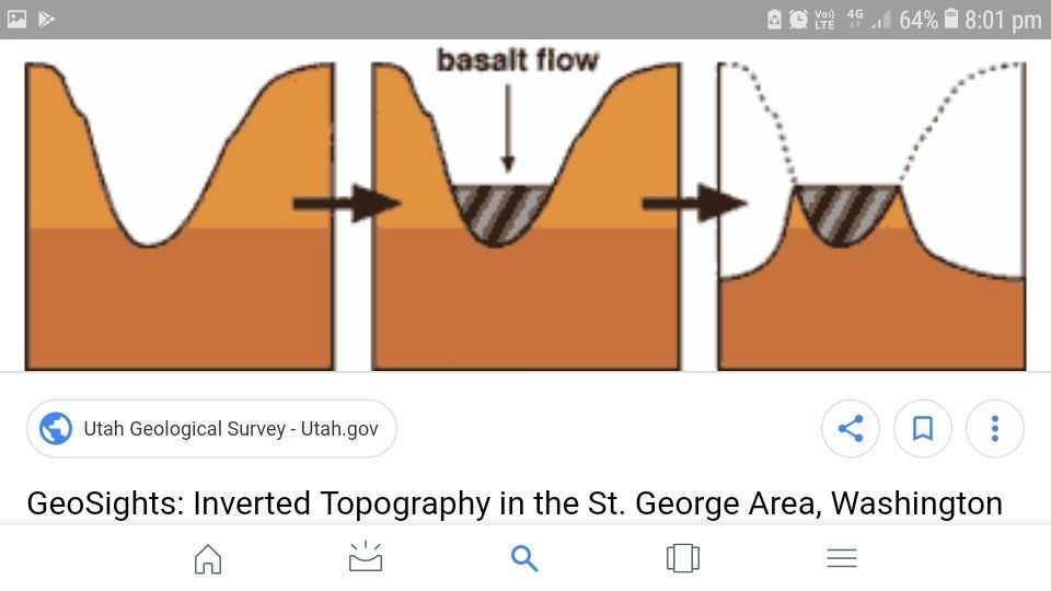
madtuna said:But what is now uphill was once downhill. Both sides of the original reef were once downhill. The only difference being one side eroded, weathered away quicker than the other.
Dunno...but laterite forming over bedrock gets me kinda excitedAussiedigs said:madtuna said:Gold can fall off either side of the reef and I've found good gold on the uphill side many many times.Aussiedigs said:Gold is where you find it. Im beginning to think this saying was more relevant to times past to an extent. Ok, it still stands true but not to the extent it once did.
One thing ive learnt through research is there are differences of opinion which both/all can be correct. Work the worked ground, work between the worked ground etc.
I took the dogs for a 2 hour walk yesty up a gully beyond some workings. Now heres another thing i read last night - dont bother detecting above reefs! Anyway i kept hitting fencing wire. Didnt matter how far up I travelled, more fencing wire. I got to virtually the top of the low gradient part of this gully and got a single travelling along under the surface. Barbed bluddy wire stretched across under the surface! The finest (smallest) barbed wire ive ever seen. Was a miner camped up in here containing some sheep hence the fine wire? One thing i have learnt is the likes of the metal detector can give a view to an extent of what took place in certain areas we would otherwise not see.
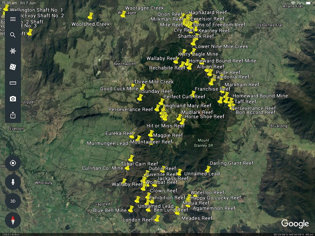
Another interesting observation, is this only because im green to all this is in this Google Earth view, the gold workings are in the hilly areas basically. So over time the earth has been pushed up to form the hills we have today. Through this process it has caused cracks in the earth for the likes of gold deposits to be made? Is this process what we call metamorphism?
https://www.prospectingaustralia.co...3174_e5a727ea-7ae8-4896-84d7-6093d2535991.jpg
Maybe what im reading is mostly gold wont fall uphill but what if the reef continues up there? To me this is working between the workings. As Kingswood pointed out if the rocks etc extend beyond...well!

Where I live they are north south...I presume because thats the way the greenstones run.Mackka said:I love this thread, very interesting.
Are all the mines North South?
Mackka
What I should have wrote was "what is now uphill MAY have once been downhill"Aussiedigs said:madtuna said:But what is now uphill was once downhill. Both sides of the original reef were once downhill. The only difference being one side eroded, weathered away quicker than the other.
Geez Madtuna, your making me use my brain! :awful
Is this what you are suggesting?
Erosion forms hills by carrying away all of the soil on a mountain, causing a hill to be left behind
http://www.edu.pe.ca/southernkings/hillmc.htm
madtuna said:What I should have wrote was "what is now uphill MAY have once been downhill"Aussiedigs said:madtuna said:But what is now uphill was once downhill. Both sides of the original reef were once downhill. The only difference being one side eroded, weathered away quicker than the other.
Geez Madtuna, your making me use my brain! :awful
Is this what you are suggesting?
Erosion forms hills by carrying away all of the soil on a mountain, causing a hill to be left behind
http://www.edu.pe.ca/southernkings/hillmc.htm
What I mean is picture a mountain millions of years ago with a reef just showing out the top.
Weathering/erosion causes the soil surrounding the reef to erode at a faster rate than the reef itself. As the reef slowly erodes, rocks and gold fall off both sides.
Due to wind and rain predominantly coming from one dirrection, one side erodes quicker than the other side. So although millions of years ago what might have started out equal, today we might have an upside and a down side of the reef.
Sometimes the land is flat with a reef in the middle... both side eroded at the same pace, so no upslope and no downslope.
Yes, the overwhelming majority in eastern Australia. It has to do with the Pacific sea floor diving westward under the east coast of Australia for a very long time - "pushing" westward against the continent and opening up north-south fractures etc. We don't see this happening now because the Tasman Sea opened up, and the area where the ocean plate met the edge of the Australian continent is now out in New Zealand and New Caledonia.Gimp said:NS alignment of mines\major fault lines in Oz is well known fact. Look at any map showing faults.
Thank you Sirgoldierocks said:Probably most large nuggets everywhere tend to be eluvial, not just in WA. Smaller ones travel hundreds of metres in streams (remembering that WA had high rainfall when they were being moved around, in more deeply incised valleys that have since been filled in to a large degree. But some nuggets are neither, they have actually grown in ferricrete (ironstone) when gold was redistributed by saline groundwater. So things like a lack of roundness can simply reflect that the nugget grew where you see it now. Some economic gold orebodies are actually the laterite/ferricrete itself because of this re-concentration of gold - some gold nuggets actually enclose original "soil" (e,g, iron pisolites). One mine at least mined bauxite and gold together (bauxite is really an aluminium rich soil (Boddington - later primary gold was found at depth). Butt is a good reference.
As you say, gold is not "where you find it" - it occurs in specific places for good geological reasons. Some of it requires a lot of knowledge of geology, but there are simple rules that will increase your chances of success tenfold. One of them is understanding the difference between primary gold in unweathered rock, gold in the weathering zone (lateritic profile in WA), eluvial gold and alluvial gold - and the fact that the desert country you see now is not what it was like when the gold was being moved around. Since it turned to desert there has been little movement of gold beyond what breaking up of rock into fragments ("desert lithosol" - a surface veneer of broken rock fragments) and wind movement has caused. And that involves very little movement.
a couple of things:kingswood said:Thank you Sirgoldierocks said:Probably most large nuggets everywhere tend to be eluvial, not just in WA. Smaller ones travel hundreds of metres in streams (remembering that WA had high rainfall when they were being moved around, in more deeply incised valleys that have since been filled in to a large degree. But some nuggets are neither, they have actually grown in ferricrete (ironstone) when gold was redistributed by saline groundwater. So things like a lack of roundness can simply reflect that the nugget grew where you see it now. Some economic gold orebodies are actually the laterite/ferricrete itself because of this re-concentration of gold - some gold nuggets actually enclose original "soil" (e,g, iron pisolites). One mine at least mined bauxite and gold together (bauxite is really an aluminium rich soil (Boddington - later primary gold was found at depth). Butt is a good reference.
As you say, gold is not "where you find it" - it occurs in specific places for good geological reasons. Some of it requires a lot of knowledge of geology, but there are simple rules that will increase your chances of success tenfold. One of them is understanding the difference between primary gold in unweathered rock, gold in the weathering zone (lateritic profile in WA), eluvial gold and alluvial gold - and the fact that the desert country you see now is not what it was like when the gold was being moved around. Since it turned to desert there has been little movement of gold beyond what breaking up of rock into fragments ("desert lithosol" - a surface veneer of broken rock fragments) and wind movement has caused. And that involves very little movement.
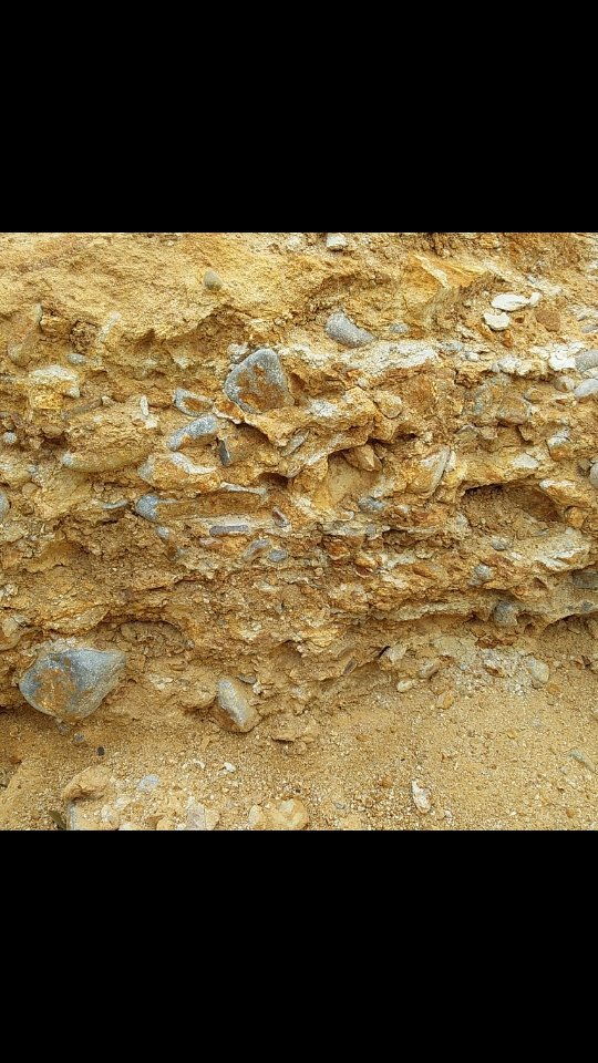
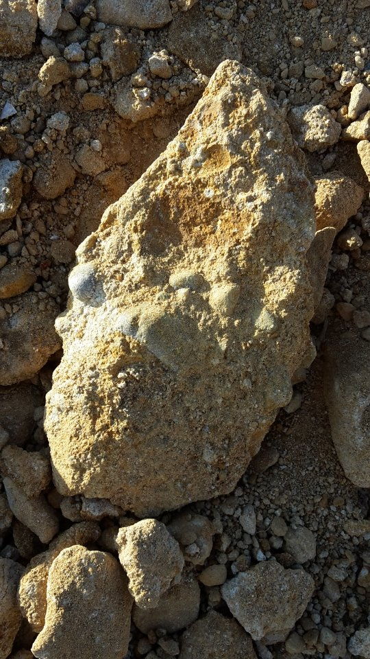
Have done lots more reading about lateritic weathering.....
Would it be fair to say that primary nuggets found in the upper laterite, mostly 2-5g's, would be close to the source due to the halo dispersion pattern?
Thank you for this. This is very helpful to me and confirms that all the reading i have been doing is finally sinking in!goldierocks said:a couple of things:kingswood said:Thank you Sirgoldierocks said:Probably most large nuggets everywhere tend to be eluvial, not just in WA. Smaller ones travel hundreds of metres in streams (remembering that WA had high rainfall when they were being moved around, in more deeply incised valleys that have since been filled in to a large degree. But some nuggets are neither, they have actually grown in ferricrete (ironstone) when gold was redistributed by saline groundwater. So things like a lack of roundness can simply reflect that the nugget grew where you see it now. Some economic gold orebodies are actually the laterite/ferricrete itself because of this re-concentration of gold - some gold nuggets actually enclose original "soil" (e,g, iron pisolites). One mine at least mined bauxite and gold together (bauxite is really an aluminium rich soil (Boddington - later primary gold was found at depth). Butt is a good reference.
As you say, gold is not "where you find it" - it occurs in specific places for good geological reasons. Some of it requires a lot of knowledge of geology, but there are simple rules that will increase your chances of success tenfold. One of them is understanding the difference between primary gold in unweathered rock, gold in the weathering zone (lateritic profile in WA), eluvial gold and alluvial gold - and the fact that the desert country you see now is not what it was like when the gold was being moved around. Since it turned to desert there has been little movement of gold beyond what breaking up of rock into fragments ("desert lithosol" - a surface veneer of broken rock fragments) and wind movement has caused. And that involves very little movement.
Have done lots more reading about lateritic weathering.....
Would it be fair to say that primary nuggets found in the upper laterite, mostly 2-5g's, would be close to the source due to the halo dispersion pattern?
(i) the nuggets found in the laterites are usually secondary, not primary. Primary nuggets (that were deposited with quartz veins etc) usually have at least 3% silver (up to more than 50% silver). Secondary nuggets that grow in laterites usually have no detectable silver (e.g. they are 99.7% gold, the 0.3% commonly being copper).
(ii) any nuggets found within the laterite are usually above or only offset horizontally at most tens of metres from the source at depth (but that can be as much as 30 m below, often with white clay lacking gold in the intervening interval). The nuggets actually grow in the iron-rich ferricrete at the top of the laterite (the gold gets dissolved from the primary ore at depth and re-deposited where there is iron near surface - they actually require the iron for the gold to be re-deposited). For those chemically inclined the gold is dissolved in cold, oxygen-rich, highly salty water at depth as a gold chloride ion, and has to be reduced again to metallic gold by encountering iron (oxidation state +2) that reduces it to metallic gold. Nuggets of this type sometimes have ironstone inside them, completely enclosed by gold. Since we know the ironstone formed by weathering, the gold must also have deposited in the weathering zone because it includes ironstone inside it. When the gold dissolves from silver-rich gold at depth, the silver and gold separate from each other and re-deposit separately (sometimes the silver simply stays in the groundwater and washes away), giving the high purity of secondary gold nuggets.
!!!Enter your email address to join: