One of my fav sites to find historical sites is TROVE. It has old newspapers, journals, maps etc etc all digitized. A great resource. If you search for something like a park, oval, racecourse etc etc you can read up on what events took place on that site. It will give you an idea of how popular such a site was. Of course I am talking about older coins and relics rather than gold but you will find historical records on gold sites as well.
Thats a tricky one, my favourite search site is best used by gathering info from a number of other sites first so really you could call it my favourite search system.
I always found it difficult to visualise elevation from just looking at topo maps, I always seemed to underestimate how steep the terrain was,
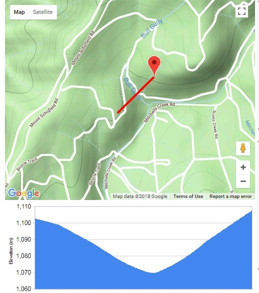
I use this tool to let me visualize the terrain is for areas that i am planning to visit, it is also good for highlighting large benches/depressions/workings. Also good to check before going to a new area so you know roughly how steep the terrain is.
you just search for the area you are interested in then click your route on the map and it will give you a terrain graph at the bottom of the page.
example below - Bulls Gully Sunny Corner - cross section of the gully
Yeah, topo maps can be that way. Generally the closer the lines, the steeper it is. The wider apart between the lines shows a flatter area. The tighter... the higher!
Yeah, topo maps can be that way. Generally the closer the lines, the steeper it is. The wider apart between the lines shows a flatter area. The tighter... the higher!
Yeah no troubles in reading topo maps, sometimes its just easy to underestimate how steep something is until you see it in cross section or in numbers so you can easliy work out the grade of slope it is very easy to underestimate scale when looking at sat maps or topos only.
Google Earth 3D is pretty good for getting a look at the lay of the land too.
Probably my favourite for Crown Lands etc. (when it's working) http://nswtitles.minerals.nsw.gov.au/nswtitles/
")