Creswick

Prospecting Australia

Help Support Prospecting Australia:

This site may earn a commission from merchant affiliate links, including eBay, Amazon, and others.
It is funny how philosophies differ - if it is 0.01 g, I need 3000 of them to make 4-5 days pay and the old back is getting frailer.....

Creswick was historically a great nugget field - geologically it is the continuation of Ballarat and 50 tons of gold came out of Creswick alone, nearly half of it fairly shallow and almost none out of the gold reefs (quartz veins is a better term).
 
So then, right place, right time, right angle of swing of the detector and they're some good sized stuff to still be found... I'm not looking for the welcome stranger but wouldn't mind a few grams :)

I'm going to fully digest your posts Goldierocks and get back to you :p thank you!

Can I locate the reef you refer to on Geovic?

goldierocks said:
It is funny how philosophies differ - if it is 0.01 g, I need 3000 of them to make 4-5 days pay and the old back is getting frailer.....

Creswick was historically a great nugget field - geologically it is the continuation of Ballarat and 50 tons of gold came out of Creswick alone, nearly half of it fairly shallow and almost none out of the gold reefs (quartz veins is a better term).
 
I go to creswick a fair bit it's not far from where I live Iv never found anything bigger then a 0.03g but they add up at the end of the day if you find enough of them more then anything it's fun I'd rather pick up tiny gold all day then walk around all day and only find trash ..I only use the 8" at creswick and Blackwood .everywhere else I use the 11" ...I'm sure there's still decent nuggets in creswick but I'm yet to find one ..there's nice gold all over the triangle just got to find it :D
 
is it generally reefs uphill that have shed the gold?

No, it is just that gold starts off in the quartz reef and weathers out of it into the soil, and gravity says it can then only move downhiill so one looks below, not above, the highest reef(s) on a hill

Is there a way of identifying on Geovic leads etc? i.e. Black lead

I suggest on the geological survey of Victoria site go to maps and select goldfields maps and select the one for Creswick. Much more detail than on Geovic

So how can you find a reef in an area?

Geovic shows them, but the detailed maps of goldfields that I mentioned have much more detail - the maps by Doug Stone shows them clearly and are often easier to read (used to know him when I was still in High School, now nearly 70)

so the gravel you refer to is that a thin layer of 'gravel' that is clearly differentiated from the soil around it?

Well- it depends on the situation. If you look down an alluvial mining shaft from its collar, there will usually be soil first (clay, rock fragments, sand), followed by clays and sands deposited in the old stream (which often don't look much different to soil because both often have clay, but may be a different colour), followed by the gravel of the old stream with its gold (rounded quartz pebbles), followed by hard bedrock that the stream flowed over (although only some of these are often present because most shafts are partly filled). The point is - if you can only see clay for greater than detector depth why bother? Don't forget that it doesn't take long to take a 2 inch diameter posthile digger down to greater than detector depth, and it will tell you what is there (although it may just bounce on quartz gravel, but you usually get a few broken quartz gravel fragments). Quartz gravel is the best gravel as it shows that the old stream was deriving its gravel from lots of quartz veins, with more chance of gold than if the gravel pebbles are mostly rock (it also heps distinguish true stream gravel from just broken bedrock fragments). Be careful also that often old mining waste has been dumped on top of the old soil layer etc.

Also, if you can't see the gravel, but lots of workings, can you take the depth of the workings to assume that was the depth of the gravel and it's best to work uphill from that.

Yes, with alluvial workings that is a good point, as often the sides of shafts are too dirty to distinguish gravel and are best not to climb in (what looks like the bottom is sometimes just a pile of fallen branches covered by later dirt)- so as you say, if most alluvial shafts are still open to greater than detector depth, just detect their shaft dumps or move uphill

Also, with the green leads is that deep alluvial

Yes. although there is no consistency - you mostly want to be in red dots, or in the very uppermost (up-the-hill end) of any green leads. Most green leads are too deep for you, but can still be OK in their former "headwaters"

Apologies for all of the 'beginner' questions... appreciate the help.

The best way to learn is to ask, and then make a few mistakes and ask again

So are there any places where there are still nice size nuggets?

Fair crack of the whip mate! If I told you I would have to shoot you.....

This attached file might also help - sorry, it was too large (up to you if you want to give me somewhere I can email it, I understand if you don't, or maybe the moderator could pass your address to me without posting, or pass my dropbox address to you where you could collect it). It is a paper on Victorian gold geology for non-geologists, with photos of things like quartz reefs on hillsides, gold-bearing quartz gravels photographed in pits, cross-sections explaining deep leads and shallow leads, the gold-mining history of the Ballarat-Creswick area......
 
Oz_Gold said:
So then, right place, right time, right angle of swing of the detector and they're some good sized stuff to still be found... I'm not looking for the welcome stranger but wouldn't mind a few grams :)

I'm going to fully digest your posts Goldierocks and get back to you :p thank you!

Can I locate the reef you refer to on Geovic?

goldierocks said:
It is funny how philosophies differ - if it is 0.01 g, I need 3000 of them to make 4-5 days pay and the old back is getting frailer.....

Creswick was historically a great nugget field - geologically it is the continuation of Ballarat and 50 tons of gold came out of Creswick alone, nearly half of it fairly shallow and almost none out of the gold reefs (quartz veins is a better term).

Not sure if that reef is on Geovic and I have run out of time and must go back to bread-and-butter work for now - Im sure if you look there will be a mine layer and it probably distinguishes reef (quartz) mines from alluvial gold mines, Probably doesn't show the actual reefs. Suggest you look at and if suitable but Doug Stones metal-detecting map of Creswick at the Sovewreign Hill shop (in its car park outside).
 
Mickybees said:
I go to creswick a fair bit it's not far from where I live Iv never found anything bigger then a 0.03g but they add up at the end of the day if you find enough of them more then anything it's fun I'd rather pick up tiny gold all day then walk around all day and only find trash ..I only use the 8" at creswick and Blackwood .everywhere else I use the 11" ...I'm sure there's still decent nuggets in creswick but I'm yet to find one ..there's nice gold all over the triangle just got to find it :D

Yeah, and most people can say the same about many places they have detected where people still find nuggets. Even if you are looking in the right place it is still hard yakka and a good dose of luck. Creswick is the continuation of the Ballarat reefs, just to the north a bit, and Ballarat was one of the world's biggest nugget fields, with 460 tons of gold, about 430 tons of it alluvial and 7 nuggets over 15 kg alone (a couple at the northenmost end of the field - a few km north of that is a field that produced 10 to 30 oz nuggets, a few km further north one with nuggets of similar size, a few km further north up to 800 oz nuggets, and a few km north you are into Creswick...which produced 52 tonnes of alluvial from memory, almost all of it alluvial or eluvial and with plenty of nuggets.

I personally know of people who got lumps of 4 g at Creswick and I know many nuggets of 10 to 400 oz came out of within 10 km of there in the last decade (people tend not to give grid coordinates of their finds). To quote one person on a website:

"The Creswick field is vast and the work the old timers did is mind blowing just like all the fields over here, they make Tasssie fields look like a drop in the ocean. the Portuguese and Chinese were a big part of establishing the field. like so many others in the triangle, even as late as 1930 Lenny Goldsmith with hydraulic sluicing took kilos of gold nuggets some as big as cricket balls".

The sluicing areas are of course shallow areas suitable for detecting.

Think big lad, think big!
 
So then, right place, right time, right angle of swing of the detector and they're some good sized stuff to still be found... I'm not looking for the welcome stranger but wouldn't mind a few grams :)

I'm going to fully digest your posts Goldierocks and get back to you :p thank you!

Can I locate the reef you refer to on Geovic?

It is funny how philosophies differ - if it is 0.01 g, I need 3000 of them to make 4-5 days pay and the old back is getting frailer.....

Creswick was historically a great nugget field - geologically it is the continuation of Ballarat and 50 tons of gold came out of Creswick alone, nearly half of it fairly shallow and almost none out of the gold reefs (quartz veins is a better term).

Not sure if that reef is on Geovic and I have run out of time and must go back to bread-and-butter work for now - Im sure if you look there will be a mine layer and it probably distinguishes reef (quartz) mines from alluvial gold mines, Probably doesn't show the actual reefs. Suggest you look at and if suitable buy Doug Stones metal-detecting map of Creswick at the Sovewreign Hill shop (in its car park outside).

OK - I am seriously into the gold business, but here is a reduction of one of my Victorian GIS compilations from all existing goldfields maps just to give you an idea of how many reefs there are and where they are (every reef in the map area that has produced gold is shown). It has the advantage that reefs are almiost entirely only in areas shallow enough for either soil or alluvial detecting. Lines show the extent of each reef, but where I only had a shaft that I knew was on a reef, but not its extent, it is shown as a cross. For me, I can click on the GIS coordinates accurate to perhaps 5 to 15 m - for you, you will have to go to the individual goldfields maps and use your navigation skills. But it gives you the idea (I have done this for all of Victoria except SOuth Gippsland and Tanjil region and Dandenongs that I am doing now, and most of Tasmania and much of NSW). Happy to help (a bit) some friends with common interests. :cool:

1477464111_reefs2.jpg


Pity that paper is too big to load
 
Oz_Gold,
For showing reefs and faults in GeoVic, use:
1. Geology,
2. Interpretations,
3. State Wide Data (1990 - 2006),
4. Geological Lines & Faults 100K,
You will need to set your scale set at 100K or less to see them.
 
You guys are welcome. BigWave, I don't have time to chase up on Geovic now, but geological lines and faults never used to include reefs (I have contributed to the data they use). Faults (almost certainly those shown are without gold veins) and reefs (veins) are completely different things. Faults are basically cracks in the rock that started forming fairly continuously billions of years ago and still keep forming - earthquakes occur on them when they move. People sometimes get confused, because hot fluids can pump into a very small proportion of the very smallest faults at very limited times in geological history and deposit quartz and gold and then seal them so they often no longer move - but we then call those veins or mineral deposits not faults. Old miners call them "reefs" and the usage has persisted (I don't like the term because they also used it for any other hard layer of rock, so if you read old reports from the alluvial deep lead mines you will see reference to "reefs" when in fact 90% of the time they are referring to hard layers of sedimentary sandstone rock - which was often a nuisance for them because they would have to blast through it when they reached one to keep their workings at a constant level, which was the average gradient of the old valley floor).

I just checked Geovic - that layer says "This dataset contains primary geological data, namely outcropping/sub-cropping geological rock units and boundary types separating rock units. Other geological features (e.g. fault or dyke) are included where the feature forms a boundary to rock units." So in other words, not reefs (which would never form a boundary at the scale of a map). There is also a "miscellaneous lines" layer, but it also does not appear to include reefs (not mentioned in its description).

I also use Geovic in a different way to you (although it is very useful for a rapid search - I call up an area as you do, superimpose the geology, superimpose historical mine workings, superimpose current exploration licences or mining leases and see who holds areas at present). What you need to use are layers named things like "deep leads", shallow leads" "mineral points" and "mines and mineral occurrences" and "operating gold mines" There are many files of this type, and for most of your purposes those relating to deep and shallow leads and mines and mineral occurrences will help you best. Some of these are multiple files representing the three GIS elements of points (dots on a map), lines (which would include reefs except they don't include them - my compilation was weeks of full-time work and I may sell it one day as maps) and poilygons (areas, which are closed boundaries that can be coloured in, eg the distribution of basalt flows in the Creswick area). But none of these show reefs, which are lines. Mines and mineral occurrences are a point file - they show dots representing shafts and open pits (perhaps 10% of them at the very most, but most big hard-rock operations past and present). But not the lines of the reefs that the shafts and pits were mining (which can individually extend for kilomtretres). I can get into these files with my GIS programme and subdivide them into smaller separate files - eg gold, copper, lead - then subdivide gold into separate alluvial and quartz vein files etc. (the information is hidden in the files they provide but most people don't access this additional info).

Doesn't help you, for the map I posted I had to spatially register every old goldfields raster map on my GIS then trace the individual reefs off it one by one to form the reef layer that I used on my map. For you - decide where you want to go, go to the website and download under Maps/Goldfield Maps that goldfield map you want (as a free PDF or jpg) and use it in the field, digitally or print it (or part of it) out. For those technically minded you can register these spatially in a GIS programme (some are free) and there are even free apps that you load them into onto your Smartphone and then walk around with your phone GPS showing you where you are on the map (you don't need phone or network connection to do that).
 
I see Creswick produced more than I thought, 2.6 million ounces (over $5 billion $Australian) - all except a few hundred ounces was alluvial
 
Hi Goldierocks,

I have been following your posts and they are most informative and read them a number of times to take it all in. I too use Geovic and have a question around the layer Geological Lines & Fault [Veins item] does this indicate a gold Vein as the true definition "In geology, a vein is a distinct sheetlike body of crystallized minerals within a rock. Veins form when mineral constituents carried by an aqueous solution within the rock mass are deposited through precipitation". When I read this it sounds like a known Gold Vein and I would love your inpiut.

1477525807_capture.jpg


Rgds

Mark
 
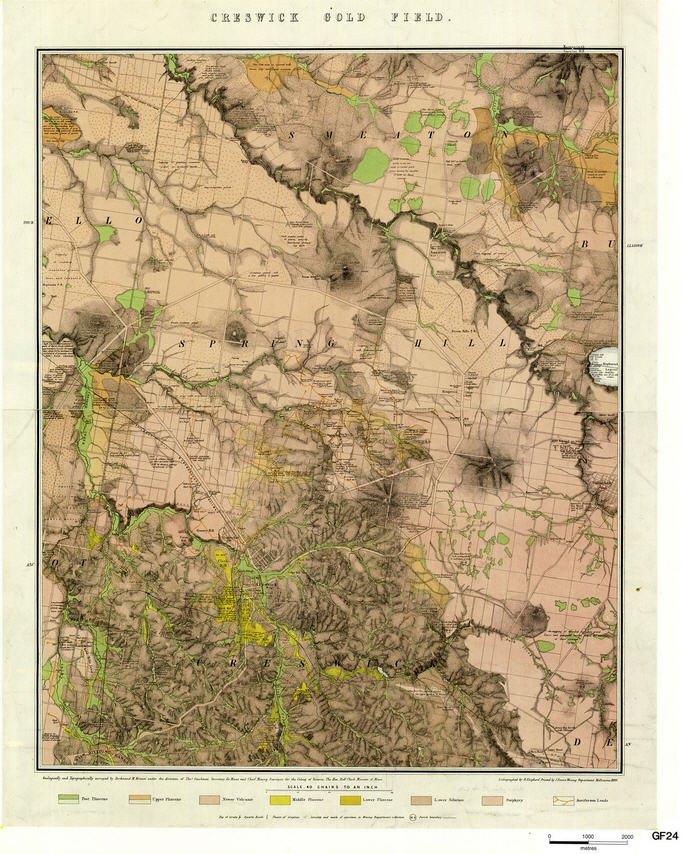
It looks like they do include some veins then, even though it doesn't meet their own metadata definition. However I would suspect that the proportion of veins shown is tiny. Why not call up the area in Geovic that I show on my map above, and superimpose the vein and town layer and see how they compare for coverage and completeness. We may find that they have incorporated new data, or even my data since they use a bit of it (however if so, it would not be at a very accurate scale). However I suspect that they took the veins only from their 100K mapping since the 1980s (which were put there from older goldfields maps) - but if so, they only cover part of the state.

The other issue is the definition of what they mean by a vein - a "mineralised" vein or just a vein. It would more likely be the latter, as many of their historical maps show not only veins with minerals of interest in them. but any type of vein, the majority being unmineralised quartz veins on some of their maps. Also other veins in Victoria contain tin, tungsten, bismuth, antimony, copper, lead, zinc etc and many of these contain no gold (most antimony veins do contain gold). However MOST economically important veins in Victoria are gold veins (in northwestern Tasmania, tin veins - in central western Tasmania, lead-zinc veins, in northeastern Tasmania, tin and tungsten veins, around Cobar many are copper or lead veins and around Sydney silver veins. In Victoria around Buchan, lead-zinc veins, around Koetong and Walwa, tin and tungsten veins, near Everton, molybdenite veins.

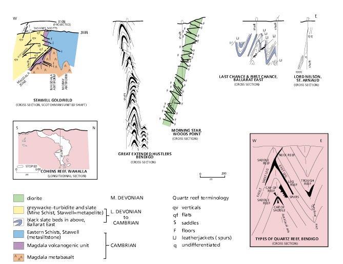
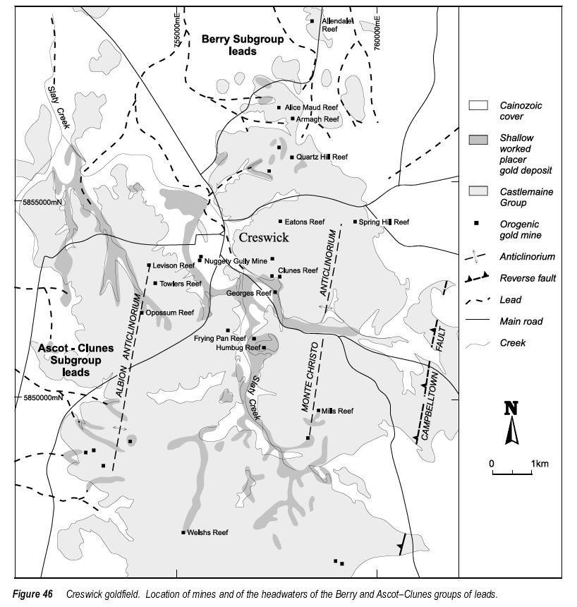
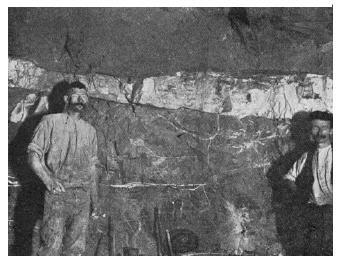
The definition you give is quite an accurate one, but it meets the definition of not only gold veins but all of these veins, including simple quartz veins that contain nothing else but quartz - all of these metals can precipitate from aqueous solutions into a fracture (when can sometimes be a fault). Also note that the definition works at any scale, so it can be a sheetlike body 2 m long that forms part of a network of veins 5 m or 20 m wide that is not sheetlike overall, and that sheetlike body might be 3 km long (such networks extend at least 16 km around Ballarat, as the Ballarat Werst, Ballarat East and Nerrina (Little Bendigo) fields. Also sheetlike and planar are not synonomous terms, so a vein can be sheetlike but curving. Most big mines had a collection of veins - here is a single "ladder" vein or "floor" from near Woods Point:

1477531745_laddervein.jpg


Here are some of the different vein patterns shown from different goldfieds - quartz veins shown in black (if you look at the Morning Star example, the above photo is from just one of those fairly flat ladder veins):

1477531965_vein_patterns.jpg


Example of a saddle reef from Bendigo:

1477532015_sadle_reef.jpg


A leatherjacket reef (quartz vein limits outlined in black) from a Ballarat mine:

1477532088_leatherjacket.jpg


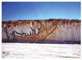
Most small mines were on single, narrow, planar veins like thiis one at Avoca shown in cross-section, but they are just as good to detect around (it is 3 m wide but continues out of the page for hundreds of metres, and above and below for hundreds of metres):

1477532521_percydale.jpg


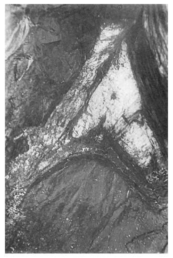
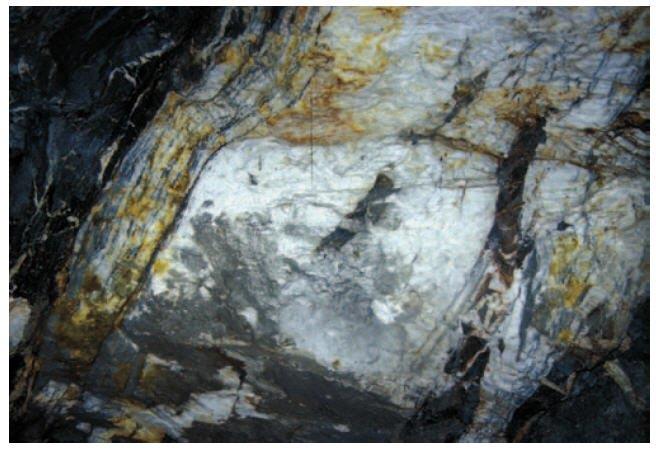
Note the fragments and layers of rock caught uo in it, because it has filled a former fault zone.

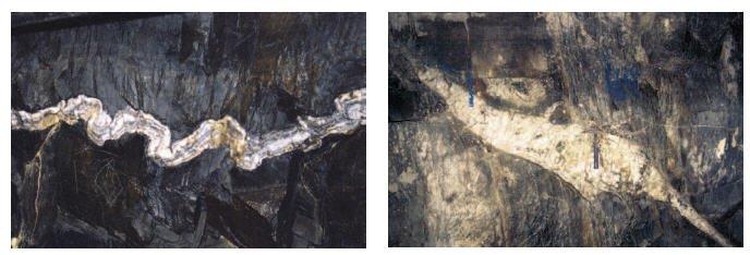
Here is a close-up of it showing multiple parallel veins within it containing pyrite, galena, chalcopyrite, arsenopyrite and gold (rich in silver - mines in areas like Avoca and St Arnaud started as silver mines) - also dark rock fragments from the fault (they were already broken up in the fault zone when ore fluids came in to form the vein):

1477532751_avoca_close-up.jpg


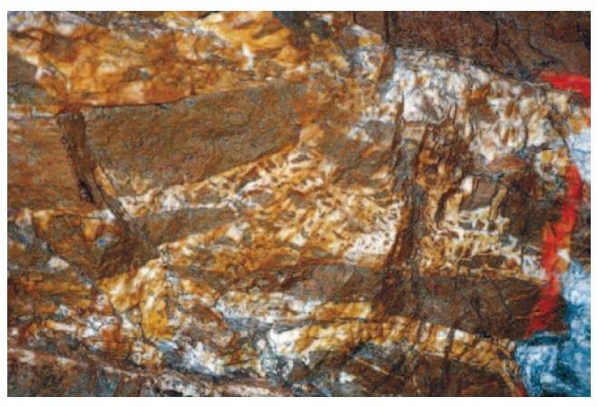
Here is a larger ladder vein from the Morning Star mine at Woods Point - we would call this a quartz breccia vein because it is so full of rock fragments from the fault it filled - assays here were 3 ounces per tonne over metres of width:

1477532840_breccia_vein.jpg


More than you wanted to know, eh? I try to keep it as simple as possible except when people ask some good questions to find ouit more (as you guys do)

So try making the comparison between Geovic and my map- if there are a lot more veins than I show they will not just be gold veins, since I show all the gold-bearing veins (but more likely there are less because they are only showing those easily taken from the main maps).
 
That didn't seem to post. Avatar a photo I took of my mate's find when in Southern Cross WA - a natural nugget of attractive leaf (or dead fish?)

Forgot this - a folded small vein from Bendigo (a rare sight in Victoria) and a tiny "spur" vein from Ballarat East

1477536617_folded_and_spur.jpg
shape.
 
Thanks Goldierocks, your input has been invaluable - so you mention layering of maps etc - but I'm not really proficient in that side of things let alone using GIS sadly - is there a resource that can show the reefs/veings (gold bearing) around Creswick or am I best to use the Doug Stone maps?
 
For now I would pick up his Crewick map at the Sovereign Hill gold shop (it is cheap, clear and useful, with modern access tracks, although if you can afford to buy his book
(which includes it and also the rest of the central goldfields) it will probably save you money in future. Probably $12.50 versus $110 from memory

and download the free Creswick goldfield map at http://earthresources.efirst.com.au/categories.asp?cID=26

Also the free Creswick 50K geology map at http://earthresources.efirst.com.au/product.asp?pID=259&cID=30 (it shows mines and leads and shallow workings)

Also free report 117 and read from p 71-110, especially p 82-83 and around 95 on Creswick

Some screen shots of them (what you download will be clearer):

1477541775_creswick_map.jpg


1477541775_creswicks_map.jpg


1477541775_creswicks_report_map.jpg
 

Latest posts

Top