With current water table levels doing what they are doing and dropping into drought, then there should be heaps of deap leads that where previously unavailable due to water. Have a look at how quickly the water table is dropping off. That's a big drought coming up.
You are using an out of date browser. It may not display this or other websites correctly.
You should upgrade or use an alternative browser.
You should upgrade or use an alternative browser.
Road Cutting / Face Strata Gallery & Discussion
- Thread starter AtomRat
- Start date


Help Support Prospecting Australia:
This site may earn a commission from merchant affiliate
links, including eBay, Amazon, and others.
Hey golddigga. Interesting to note that by the 1880s the alluvial including deeplead mining had all but finished. whereas the deeplead mines between chiltern and the murray river around rutherglen were just getting into full swing around then and didnt wind down until the first world war. I think water in these lead was much heavier as they used a slightly different method of opening the leads and draining the goldbearing drift prior to mining. It was called the upland method.
jethro said:Hey golddigga. Interesting to note that by the 1880s the alluvial including deeplead mining had all but finished. whereas the deeplead mines between chiltern and the murray river around rutherglen were just getting into full swing around then and didnt wind down until the first world war. I think water in these lead was much heavier as they used a slightly different method of opening the leads and draining the goldbearing drift prior to mining. It was called the upland method.
Bullseye FIFTY to Jethro.

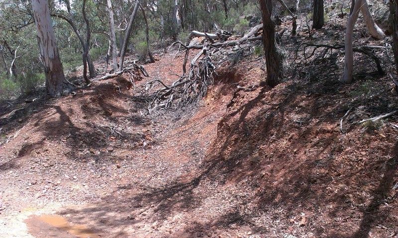
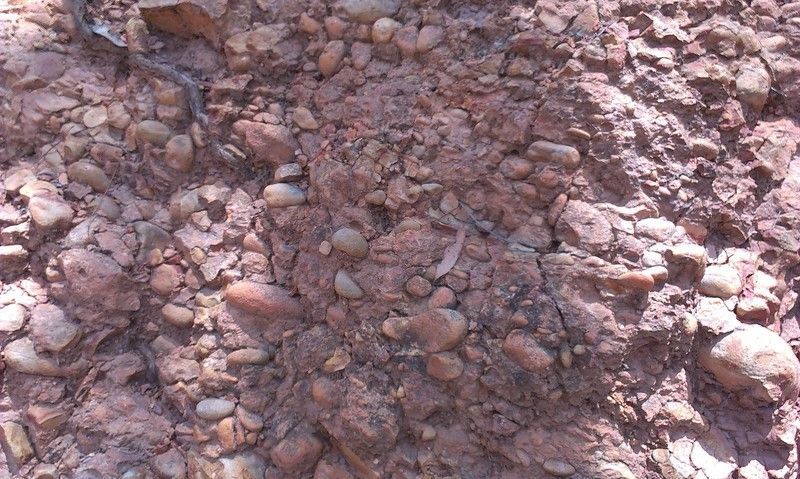
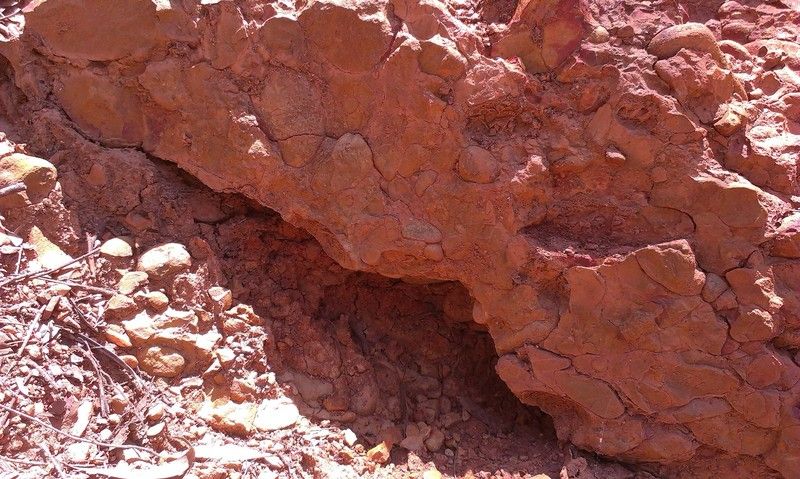
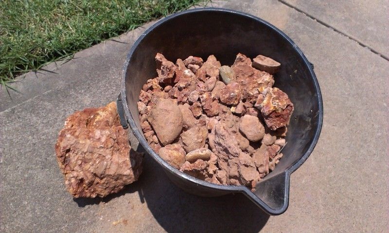
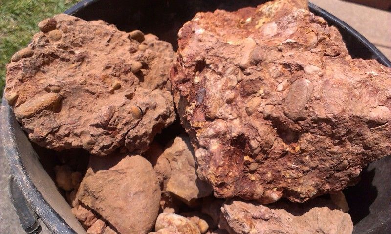
isolation said:Sorry to butt in lol... But I came across this today, on the side of a track, about 100m above the current river. Looks like water worn material... Old river? Doesn't feel like old timer diggings, more like machine dug.
http://i83.photobucket.com/albums/j281/ferguson_01/Mobile Uploads/IMAG0856.jpg
http://i83.photobucket.com/albums/j281/ferguson_01/Mobile Uploads/IMAG0858.jpg
http://i83.photobucket.com/albums/j281/ferguson_01/Mobile Uploads/IMAG0859.jpg
maybe a old logging or mining track?
Did you take a sample and test pan it?
looks good I wold say wash and by the look of it nugget bearing
isolation said:Sorry to butt in lol... But I came across this today, on the side of a track, about 100m above the current river. Looks like water worn material... Old river? Doesn't feel like old timer diggings, more like machine dug.
http://i83.photobucket.com/albums/j281/ferguson_01/Mobile Uploads/IMAG0856.jpg
http://i83.photobucket.com/albums/j281/ferguson_01/Mobile Uploads/IMAG0858.jpg
http://i83.photobucket.com/albums/j281/ferguson_01/Mobile Uploads/IMAG0859.jpg
have you got any other close ups of this wash ?
- Joined
- Sep 13, 2014
- Messages
- 769
- Reaction score
- 1,011
Hunting the yellow said:have you got any other close ups of this wash ?
Sorry mate, no. I'll post the results of the test asap
G
Guest
Isolation looks interesting indeed.
jethro said:Hey golddigga. Interesting to note that by the 1880s the alluvial including deeplead mining had all but finished. whereas the deeplead mines between chiltern and the murray river around rutherglen were just getting into full swing around then and didnt wind down until the first world war. I think water in these lead was much heavier as they used a slightly different method of opening the leads and draining the goldbearing drift prior to mining. It was called the upland method.
it is interesting stuff Jethro, they drained a few of the deep leads similarly around the outskirts of Ballarat, lal lal, devils kt5chedn etc. its amazing that they were able to trace these and open them up from the downside end.
isolation said:Sorry to butt in lol... But I came across this today, on the side of a track, about 100m above the current river. Looks like water worn material... Old river? Doesn't feel like old timer diggings, more like machine dug.
http://i83.photobucket.com/albums/j281/ferguson_01/Mobile Uploads/IMAG0856.jpg
http://i83.photobucket.com/albums/j281/ferguson_01/Mobile Uploads/IMAG0858.jpg
http://i83.photobucket.com/albums/j281/ferguson_01/Mobile Uploads/IMAG0859.jpg
very nice looking ground indeed, hopefully its the inside bend of the old river and you find yourself a nice deposit. it certainly looks like old mud with river rocks just hope its not an old muddy track that has ended up with stones being placed in it. look forward to the results
")
Looks like a drainage channel to me. Are there diggings below it? If so it may have been placed there to divert run off water away from them. Does it lead to another channel, water race or gully/area of run off?
Are there any shafts or diggings above it? Being an auriferous area there is a good chance some gold will have concentrated in it if it's not present in the actual ground already. Good luck with the samples - hopefully it shows something. Keep in mind if there are diggings around then the old timers would have been chasing "payable" gold. What wasn't payable back then can be now.
Are there any shafts or diggings above it? Being an auriferous area there is a good chance some gold will have concentrated in it if it's not present in the actual ground already. Good luck with the samples - hopefully it shows something. Keep in mind if there are diggings around then the old timers would have been chasing "payable" gold. What wasn't payable back then can be now.
Hey Jon Ive got a really good explanation of deep lead mining in victoria on a disc I got from Minerals & Petroleum back in 2000. But unfortunately its in password protected PDF format so I cant copy & paste the relevant sections. & its a bit hard to explain without the diagrams. It may be available on line as memoir #7 of the Geological survey of Victoria Titled Deep Leads of Victoria. by Stanley Hunter 1909. If you would like to pm me your email I can send it to you. the file is about 24meg so its abit of read.blisters said:What's the upland method involve Jethro?
Jon
Thanks for that mbasko
Similar threads
- Replies
- 44
- Views
- 18K
- Replies
- 8
- Views
- 3K
- Replies
- 1
- Views
- 2K