Road Cutting / Face Strata Gallery & Discussion

Prospecting Australia

Help Support Prospecting Australia:

This site may earn a commission from merchant affiliate links, including eBay, Amazon, and others.
Joined
May 22, 2014
Messages
5,146
Reaction score
5,983
Location
Katazone, VIC
I've created this topic for members to share photos of road cuttings or places which show interesting shapes, layers, folding, intrusions, veins, pockets...anything related on the subject and we can discuss these formations and sharing knowledge.

It will help with learning geology for anyone interested. Some formations I've seen are wonderful and ill upload them as I encounter them and sometimes wonder how they formed or why, also what they can hold, so rather than looking at them ill snap a few and anyone else is free to share photos of cuttings or faces showing interesting geology as well.
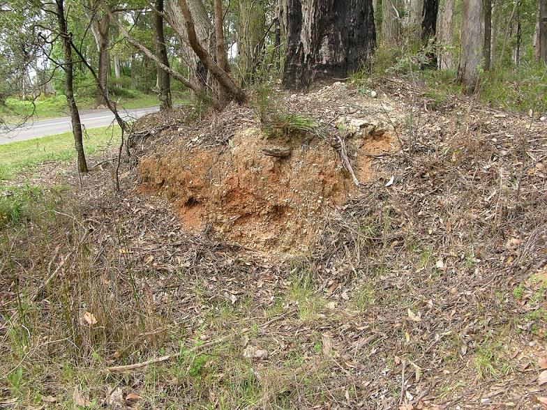
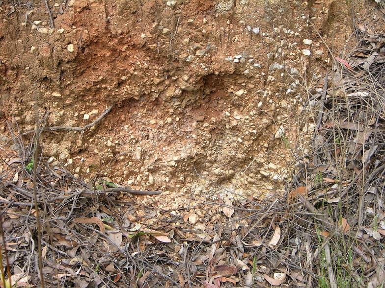
 
Got one. :) Part of a deep lead that's now high and dry
1447395976_dscn2062.jpg

1447395993_dscn2061.jpg
 
isolation said:
Parks said:
Got one. :) Part of a deep lead that's now high and dry

Do you try and picture how the land may have once looked?

Yeh, It takes a lot of research. But this came from tectonic plate movement causing the great dividing range, which pushed the reef up and made the river flow inland into a deep lead. The reef was around 2klms away and on top of the dividing range. Gradually the ocean side of the divide eroded away and now the reef flows towards the ocean. Hence this inland side is now high and dry. Funny enough there's a newer creek within 100mtrs, good spot to pan! :) .
 
I haven't got a picture of it, but a friend told me of the brand new Princess hwy roadworks near Nilma. The road collapsed within a couple of months of major works. It's on the deep lead flowing down from Tanjil area. Can anyone in that area take a picture?
 
Cheers Parks for submitting the first example! I've never seen a deep lead personally so I really like this as a first one! Is this near me at all? I don't get out to Tanjil often and I havnt heard of the deep lead there so super interesting again.

I can see some differences between this and standard alluvial I'm used to seeing. I think I've found some of this in warburton, woukd I be correct on this would u know Parks?

I thought the first example I'd be able to upload is of Andersons Creek / Dry Creek formation along Eastlink Freeway that many would know. Its nit been covered with paved rockes but they paved it in a way you can still see the strata and dykes
 
In Ballarat, the Norman St cutting looks pretty good, you can see the changes in it very easily.
I'll go over there tomorrow & see if I can get some decent pics, its a site of geological interest with the structural & sedimentary features of the Castlemaine supergroup. (thats what it says on a map I have).
 
AtomRat said:
Cheers Parks for submitting the first example! I've never seen a deep lead personally so I really like this as a first one! Is this near me at all? I don't get out to Tanjil often and I havnt heard of the deep lead there so super interesting again.

I can see some differences between this and standard alluvial I'm used to seeing. I think I've found some of this in warburton, woukd I be correct on this would u know Parks?

I thought the first example I'd be able to upload is of Andersons Creek / Dry Creek formation along Eastlink Freeway that many would know. Its nit been covered with paved rockes but they paved it in a way you can still see the strata and dykes

Like the pic I showed, at Warbuton you could be on a tributary of the old lead that went through Woori Yallock, it was a bit deep there. They move and flip and get cut off all over their path.

The lead coming down from Baw Baw area is huge! It's just that it's always completely under water. Same scenario as I described in the small mining thread today.
Tec plate movement causing great divide and the gold deposit is trapped. The new water flow now heads towards western port/ wilsons prom area.

http://trove.nla.gov.au/ndp/del/article/67430975?searchTerm=&searchLimits=l-title=139

http://trove.nla.gov.au/ndp/del/article/68728985
 
Wrong direction from the woori deep lead your talking of. I guess ill have to throw a photo up here! It could be coluvial what I'm talking bout too. Cheers for the input! I'd love to know what the landslide uncovered to the south ( Beenak ) when we had tremors last year ;)
 
AtomRat said:
Cheers Parks for submitting the first example! I've never seen a deep lead personally so I really like this as a first one! Is this near me at all? I don't get out to Tanjil often and I havnt heard of the deep lead there so super interesting again.

I can see some differences between this and standard alluvial I'm used to seeing. I think I've found some of this in warburton, woukd I be correct on this would u know Parks?

I thought the first example I'd be able to upload is of Andersons Creek / Dry Creek formation along Eastlink Freeway that many would know. Its nit been covered with paved rockes but they paved it in a way you can still see the strata and dykes

Sorry forgot to say, no that's not near you. Went to visit a friend near Creswick and it's in a town near there.
Hey! I just thought of another really good one. Blackwoods saddle reefs pop out on the hwy between bacchus and ballarat. Down by the dam south of Greendale. Can anyone in that area get a pic of it?
 
Beat me to it AR I was going to start a thread for photos of Geological structures but this one will do.

Here's my first contribution.
1447455293_dsc000011.jpg


THe photo is not very clear as I took it using the stills function of my video camera. It is of a fault that has slipped vertically with a displacement of about 3 metres. with subsequent infilling with quartz and crushed slate. The bedding planes (darker layers of rock ) that were originally adjacent to each other are now at the bottom left of the photo & the upper right.
 
On ya Jethro! I'm trying to find a fault local and havnt seen enuff examples of them to spot it I think. I can clearly see the slide on your photo and where they layers no longer meet, excellent submission. By in filling you mean quartz is in the faultline?
 
By the way folks, feel free to add a second image to show lines of fractures faults and interesting points. Using a black texta on translucent paper like grease paper and you can put the sheet on your image ( or a layer in Photoshop ) and trace lines to explain the photos clearer. Only if possible, not a necessary need. :)
 
Yes AR there is a mineralized quartz track down the fault. I havent sampled it as yet as I have a big backlog of other samples to get through. the location of the cutting is on the last Highway in Victoria to be sealed its entire length. The work was only completed 3 years ago. Notice I said Highway not road.
 
jethro said:
Beat me to it AR I was going to start a thread for photos of Geological structures but this one will do.

Here's my first contribution.https://www.prospectingaustralia.com/forum/img/member-images/1297/1447455293_dsc000011.jpg

THe photo is not very clear as I took it using the stills function of my video camera. It is of a fault that has slipped vertically with a displacement of about 3 metres. with subsequent infilling with quartz and crushed slate. The bedding planes (darker layers of rock ) that were originally adjacent to each other are now at the bottom left of the photo & the upper right.

I'm having a similar problem with my camera. Autofocus sometimes zooms in on a blade of grass and stuffs the pic up. Having to wear glasses makes it hard too.
 

Latest posts

Top