You are using an out of date browser. It may not display this or other websites correctly.
You should upgrade or use an alternative browser.
You should upgrade or use an alternative browser.
Geovic information and questions
- Thread starter tagalt
- Start date


Help Support Prospecting Australia:
This site may earn a commission from merchant affiliate
links, including eBay, Amazon, and others.
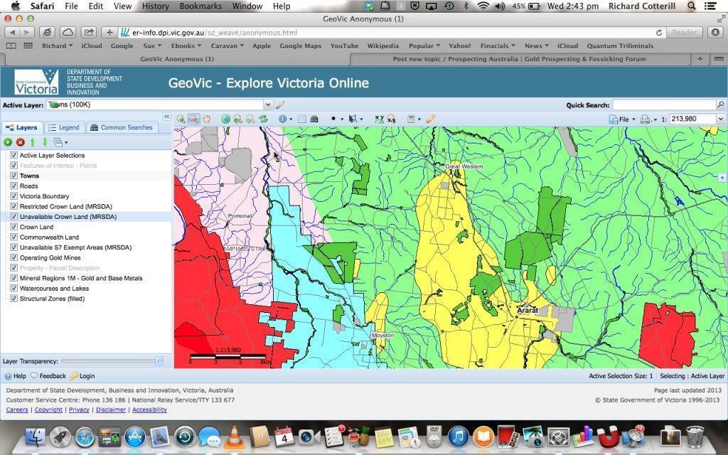
hi,
i was doing some research using GEOVIC, first time.
As a test case I picked the area around ARARAT, in particular the Ararat Hills Regional Park.
When I show the map I was looking for Crown Land. It shows this OK. When I move the Restricted Crown Layer up it seems that the whole Crown Land area is restricted.
Is this right? Does this mean I can not detect there?
It is hard to tell but the area shown seems to cover the Ararat Hills area which I thought was available for prospecting. It is possible I got this part wrong as I can noty show the parks on the map *I am only using the anonymous login).
The restricted area is the dark green.
Richard
condor22
Mike
You need to go to Parksweb Vic, they have maps that show where some prospecting is allowed in the forests and some where it is not.
They list what State parks, forests and Vic National Parks that allow prospecting.
In the 2 years I've been researching this, I've found that no one resource Geovic, or Parks give definitive does and dont's.
I tend to use a mix of Geovic, Parksweb, Doug Stone maps and in particular, Vicmap Topo 25k.
Another option is to go to the regional Park office near where you go and ask the Ranger.
An example is Paddys Ranges south of Maryborough. The area north and east of the Karri track campground is conservation, no detecting allowed. South of the camp prospecting is allowed, but.... I believe there is also a mining lease active in that area as well.
It can be confusing, I'm confused at times trying to figure it out.
I'm in Victoria and I use GEOVIC and FOREST EXPLORER to help work out the "go - no go" areas - actually GEOVIC is obviously best for the research aspect and then I refer to use FOREST EXPLORER for access info. Generally I like to work in State Forests and Regional Parks and stay clear of State Parks and National Parks.
Back to the topic....... my "understanding" is that UNAVAILABLE CROWN LAND is not available for any of the purposes that are generally allowable on other CROWN LAND.... that would include application for a Grazing License, a Plantation License, a Water Frontage Licence, an Exploration License, a Mining Lease, and I automatically assume prospecting as well. I interpret it as being PRESERVED land and as such no permissions of any sort are granted! I stay out out of the red areas.
casper
Condor22
Thanks for the reply.
I had been to that site and they say you can.
What confused me is that GEOVIC has it marked as RESTRICTED crown land .
I have tried to chase down what that means for prospecting but it is a bit unclear.
I have tried to contact the people identified and did not get any where.
Richard
Caspercasper said:I'm in Victoria and I use GEOVIC and FOREST EXPLORER to help work out the "go - no go" areas - actually GEOVIC is obviously best for the research aspect and then I refer to use FOREST EXPLORER for access info. Generally I like to work in State Forests and Regional Parks and stay clear of State Parks and National Parks.
Back to the topic....... my "understanding" is that UNAVAILABLE CROWN LAND is not available for any of the purposes that are generally allowable on other CROWN LAND.... that would include application for a Grazing License, a Plantation License, a Water Frontage Licence, an Exploration License, a Mining Lease, and I automatically assume prospecting as well. I interpret it as being PRESERVED land and as such no permissions of any sort are granted! I stay out out of the red areas.
casper
Thanks for the reply.
What you say makes sense but GEOVIC has another one called RESTRICTED crown land.
It says something like you can do it with approval or something like that. I am unsure of exact implication of this to detectors and panning.
Richard
Hi guys does anyone know if there is a function on Geovic to display the names of gully's as seen of many of the geo maps - or if this info is available elsewhere.
Lots of people refer to gully names eg American gully, Italian gully etc. It would be good to be able to search maps on this criteria.
Cheers
Kev
Lots of people refer to gully names eg American gully, Italian gully etc. It would be good to be able to search maps on this criteria.
Cheers
Kev
- Joined
- Jun 18, 2014
- Messages
- 336
- Reaction score
- 341
You can find the names of a lot of the Gullies in the John Tully series of maps, doesn't include everything but pretty good
Gully names are very hard to find at times, as are reefs, mines and leads. An example from a 1997 geomap report:
234 Unnamed Reef Reef
183 Unnamed Adit Mine
184 Unnamed Reef Reef
185 Unnamed Reef Reef
186 Unnamed Reef Reef
212 Unnamed Gully Alluvial
and this list goes on and on. Many of the geo reports are the same, even the recent reports and can cause headaches. John Tully's maps (as mentioned above) are probably the best for gold bearing areas but John will even admit they are not necessarily 100% correct but he does try to give his best guess. As can be seen, his maps have no topo data but simply a plot of where the gullies are.
condor22
Mike
Working for me ok as at 1120 Monday
- Joined
- Nov 4, 2014
- Messages
- 2,124
- Reaction score
- 5,879
Hi Oz_Gold, there's an app for iPad called Diggers Map. They give you silver locations free, then if you like the app and want to have everything else (gold,gems,minerals) layered on the map it costs $25, I think. Looks like it runs Google Earth for its mapping.
Cheers, Adrian.
Cheers, Adrian.
both geovic 2 and 3 working for me
there is an old update notice, i recommend you hold down your function key and hit f5 this will clear your cache and may fix your issue.
- Joined
- Mar 9, 2014
- Messages
- 488
- Reaction score
- 389
Look for the .kml or .kmz files and download them to your computer. Unzip them and start GE, go to open file and select the one/s you just downloaded. Bingo it should show up. You can then save them to your Saved Items.
If not you will need another program to convert them to the above files. It gets messy and you can loose a lot of details. I would be positive they have something there.
Westaus
Edit - Just had a quick look and WOW your data is very different to over here. I did not look around much but from what I saw, best of luck... 8.(
- Joined
- Jul 29, 2013
- Messages
- 1,798
- Reaction score
- 3,409
Gidday all
Just spent an hour on the geovic website trying to work out how to look at maps of gold bearing areas. I got inspired by seeing the map below posted by Walshy1000 on the Beauford thread.
Could some kind soul talk me through it please on how to get similar images as below so I can plan trips and do homework. Geez getting old is crap !! :8 8)
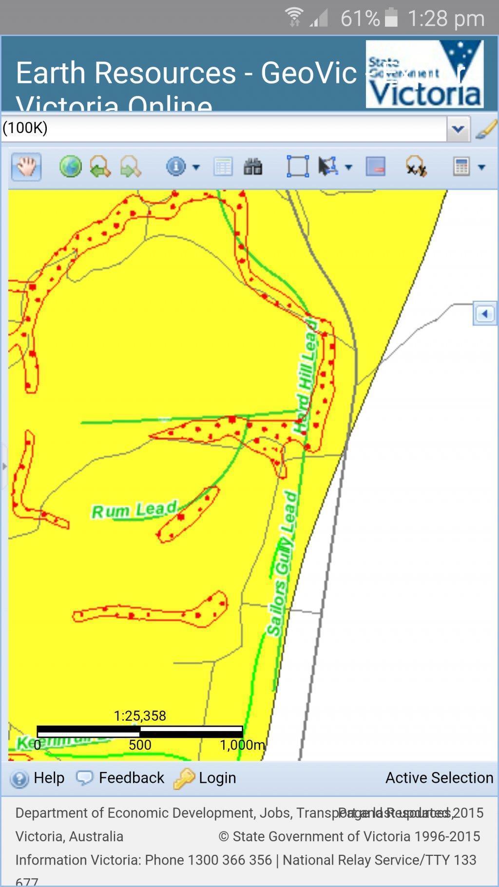
MJB
matt
Hey Gold truck,
I'm no expert mate and I don't have a smart phone so all my research is done on the laptop at home. Once in Geovic it is just a matter of clicking on the Layers tab over on the left hand side and selecting what you want to show up. For example, if you want to see minerals (like the rest of us ) open the minerals tab and select what you want. There are old gold workings, deep leads, historical mining activity etc. When you have selected them click refresh map and the map will come up showing all the layers you selected. Zoom in nice and close so you get as much detail as required.
Hope that helps a little, like I said, I'm no expert but I can just manage to get the info I need. I am always blown away by some of the mapping some guys use on here
- Joined
- Jul 29, 2013
- Messages
- 1,798
- Reaction score
- 3,409
Thanks mate I will give it a go. Gonna head out tomorrow to an area I don't have published maps or info on , so if I can find something on Geovic that will be great.
Cheers
GT")
Cheers
GT
Similar threads
- Replies
- 2
- Views
- 2K